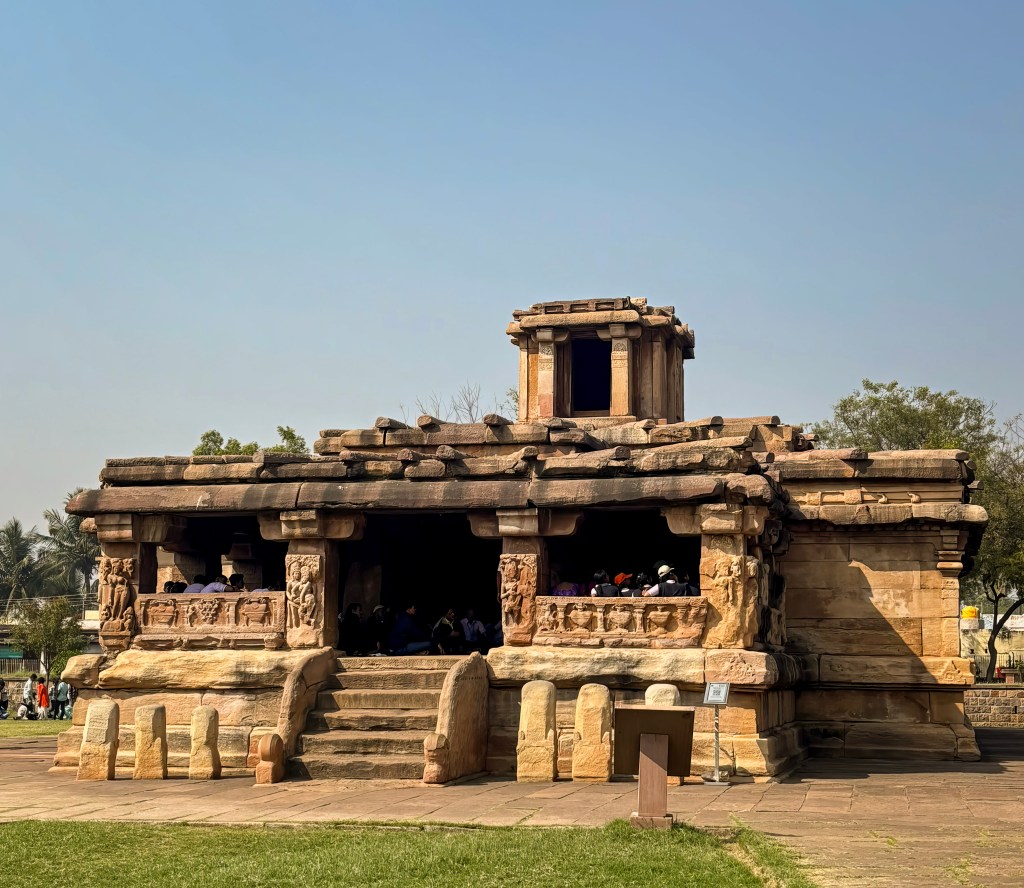
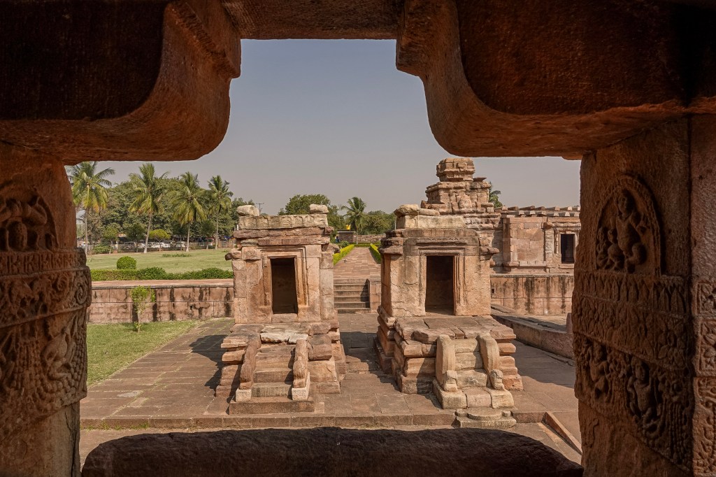
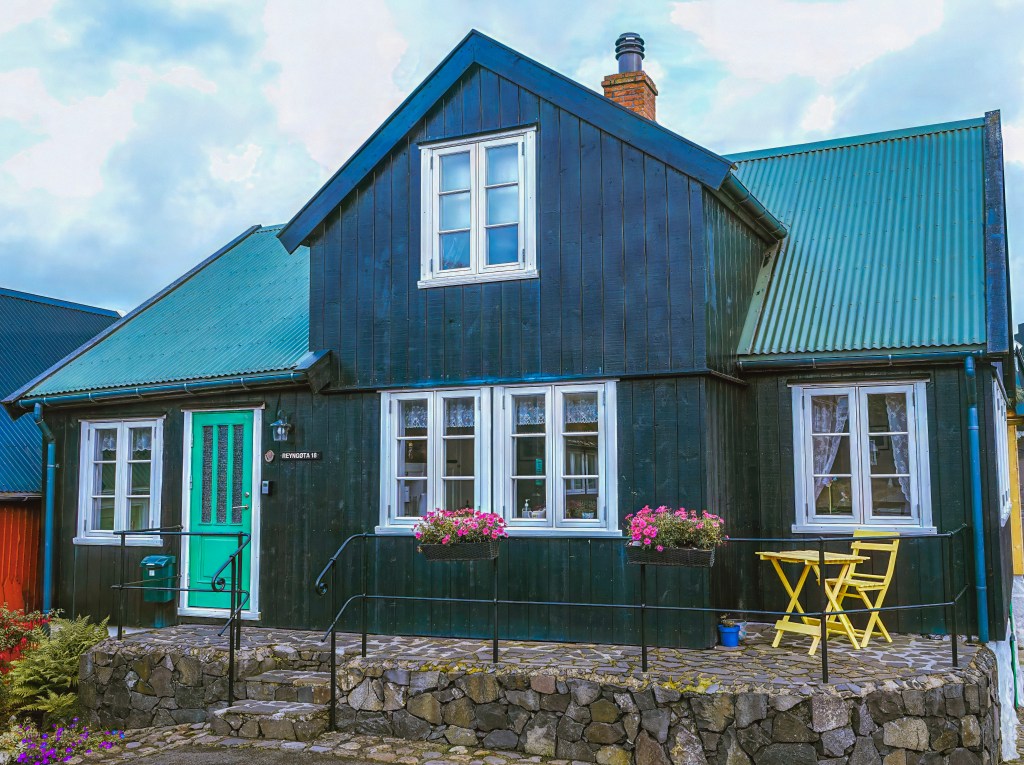
One of the most unique temples with an unusual name is the LadKhan temple. It is named after an Islamic person who used this Hindu temple as his home. This is an early 8th-century monument that was built in Panchayath style with a huge pillar hall for gathering
Nestled in the quiet village of Aihole, Karnataka—famously called the “Cradle of Indian Temple Architecture”—stands a structure that looks more like a sturdy hall than a house of worship.
The Lad Khan Temple (or Chalukya Shiva Temple) is a fascinating laboratory of design. The designers of this temple experimented with turning wooden concepts into eternal stone.
A Transition of Faith and Names
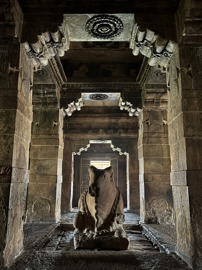
The temple’s spiritual identity has also shifted over 1,500 years. Originally dedicated to Lord Vishnu, it currently houses a Shiva Linga with a massive Nandi bull facing the inner sanctum. Some scholars even suggest it may have served as a Surya (Sun) temple. Others believe it was a royal assembly hall for the early Chalukyan kings.
Architectural Highlights
What makes the Lad Khan Temple truly stand out for modern travelers is its unique, “experiment-style” layout:
Panchayatana Style: This structure is built in one of the earliest versions of the Panchayatana (Panchayat Hall) style. It features a large pillared hall. The temple transitions from a rectangular entrance into a square sanctuary at the rear.
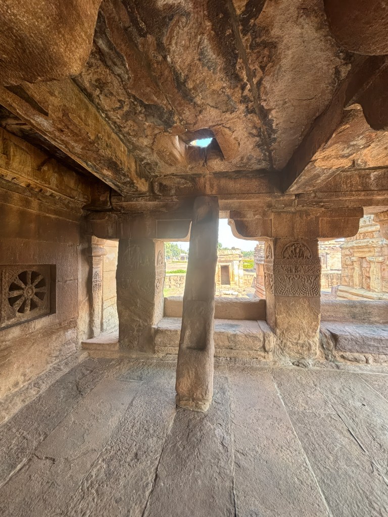
Wooden Influence in Stone: Look at the roof. You’ll see heavy stone slabs joined with stone “rafters.” These mimic ancient wooden log designs. This is a rare surviving adaptation of timber styles in sandstone.
Two-Story Sanctum: Unusual for its time, the temple includes a second, smaller square shrine. This shrine is built directly above the main central hall. It is accessible via a stone ladder.
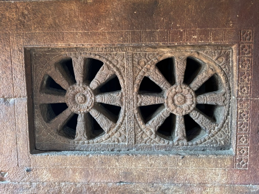
Intricate Details: Don’t miss the pillars. They are adorned with carvings of river goddesses Ganga and Yamuna. Look at the intricate lattice windows. They filter soft light into the dim interior.
Stone Ladder – Don’t miss the stone ladder that was used to climb to second floor sanctuary
Stone ladder Stone “Sofa”Lattice windows
Also, when you are at the LadKhan temple, take a look at 2 miniature temples outside. These two temples are supposed to be the models for building bigger temples, according to our guide
We really enjoyed visiting this unique temple for its architecture. My favorite part is the photograph of Nandi taken from the sanctuary. With the light in the background, this photo almost looks ethereal.
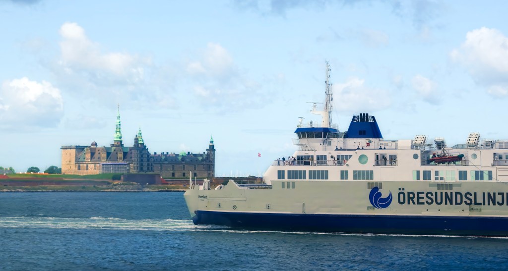
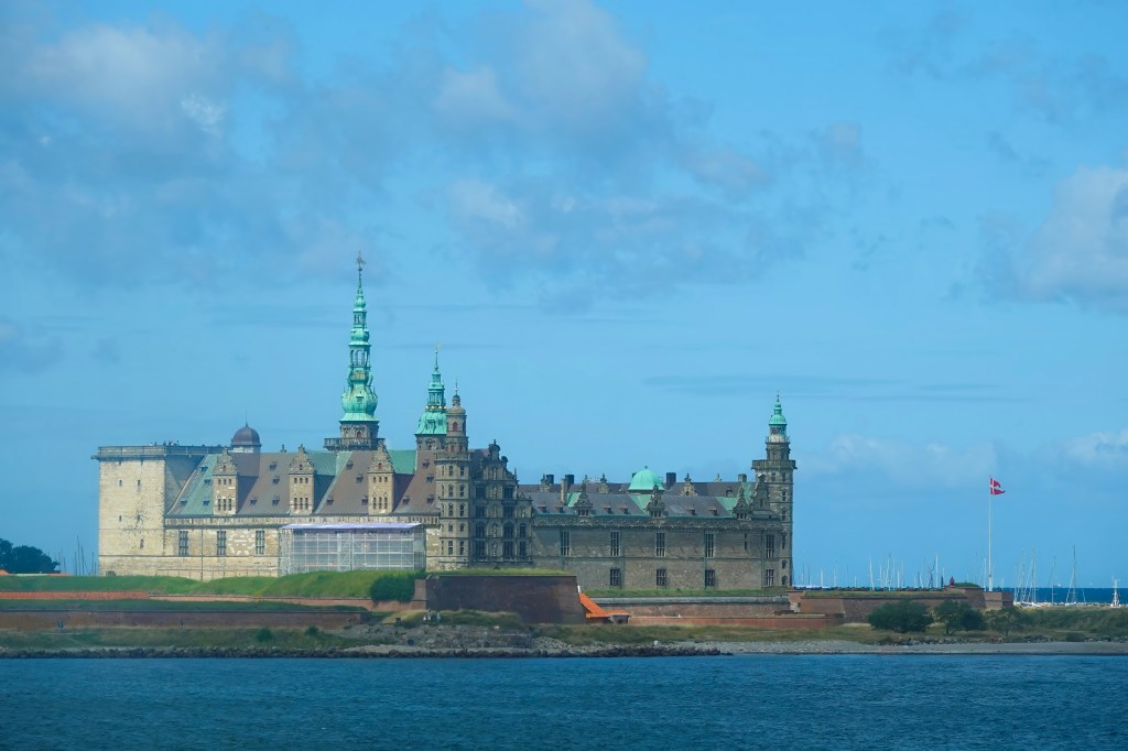
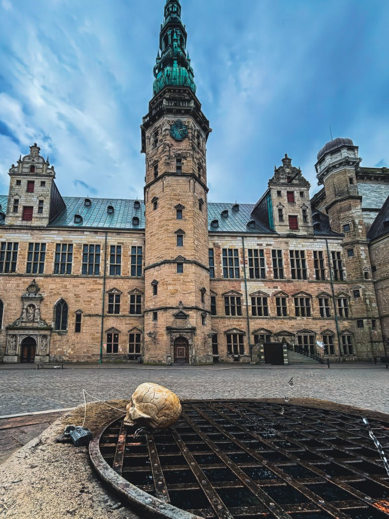
Perched dramatically on the coast of Helsingør, Denmark, Kronborg Castle is more than just a fortress—it’s a stage for history, legend, and literature. Known worldwide as the setting of Shakespeare’s Hamlet, this Renaissance masterpiece has guarded the narrow strait of Øresund since 1585, watching over the entrance to the Baltic Sea with commanding views across to Sweden. “To visit or not to visit” is not the question to be asked when deciding whether to visit this place. It should be on everyone’s list, especially if you like history
UNESCO World Heritage 🌍
Kronborg Castle was inscribed on UNESCO’s World Heritage List in 2000 for its exceptional cultural value. It joins other Danish sites like the Par Force Hunting Landscape in North Zealand, preserving Denmark’s royal and natural heritage.
Must-See Highlights of Kronborg 🏰✨
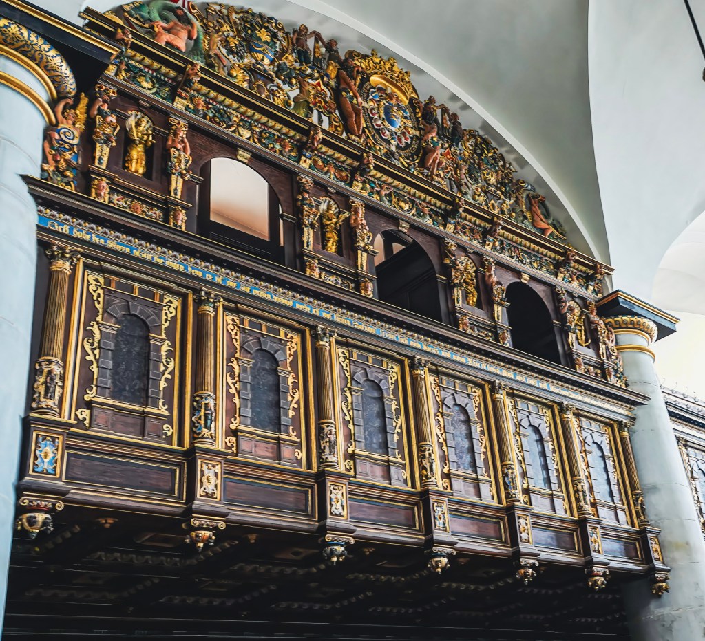
The Great Hall – One of the largest royal halls in Northern Europe, once the stage for lavish banquets and diplomatic gatherings.
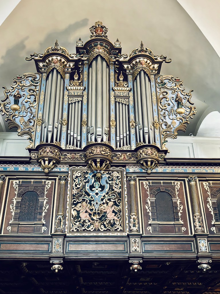
The Chapel – Consecrated in 1582, it survived the devastating fire of 1629 intact, with ornate Renaissance woodwork and gilded details.
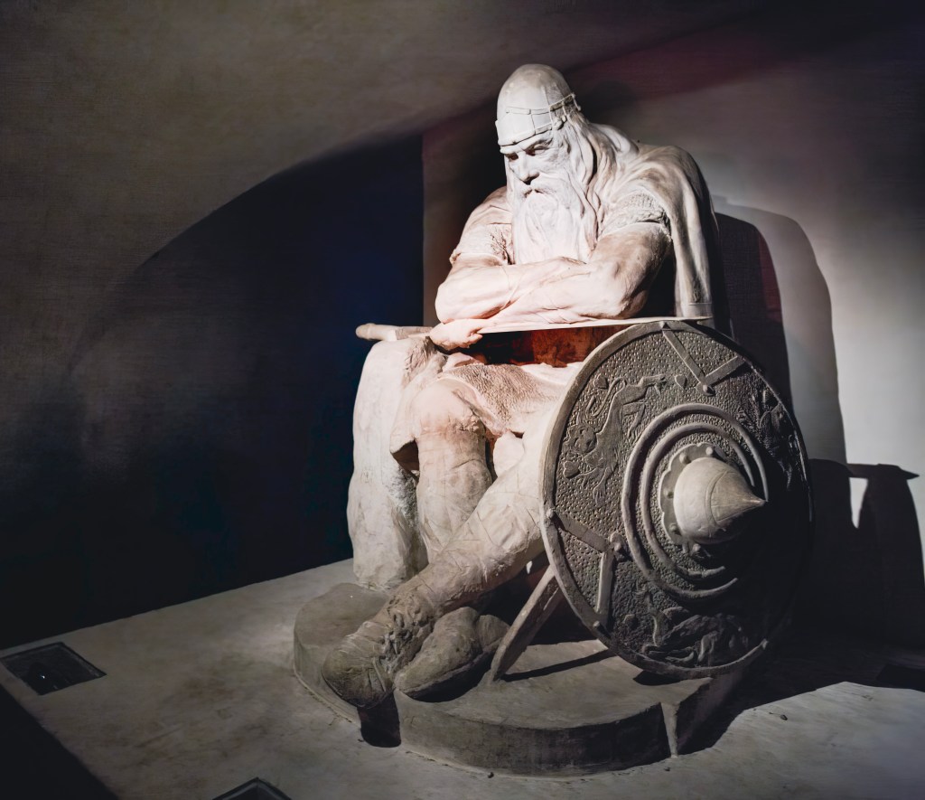
Holger the Dane – The legendary Viking warrior who slumbers in the casemates, said to awaken if Denmark is ever threatened.
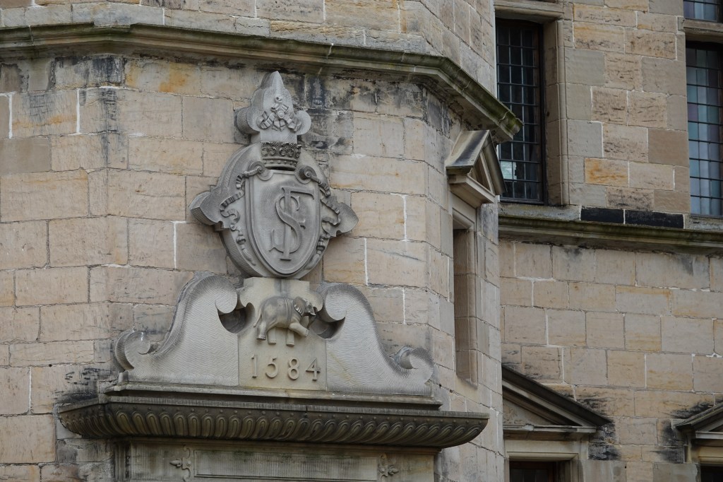
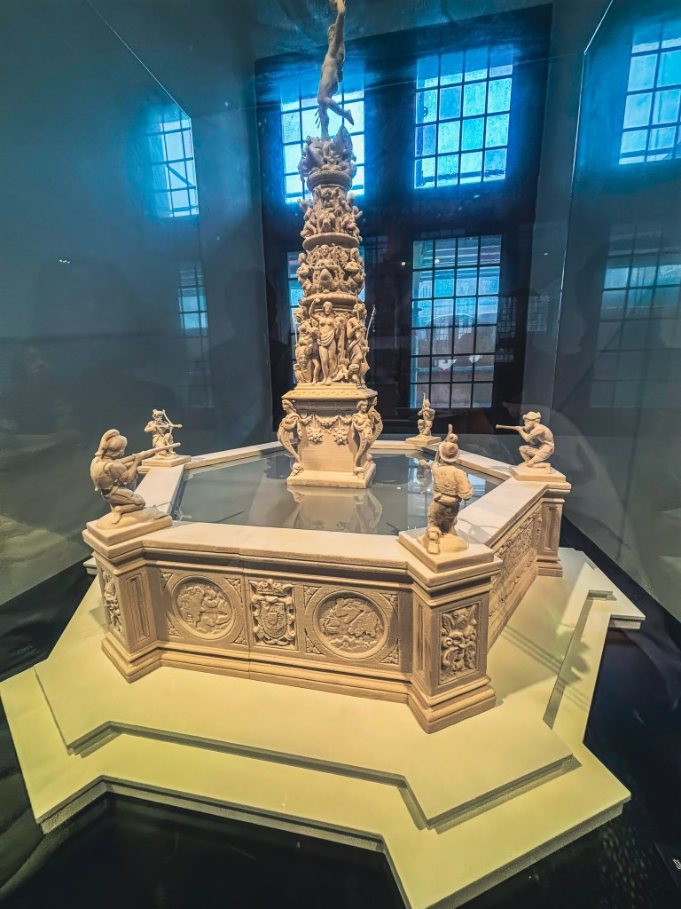
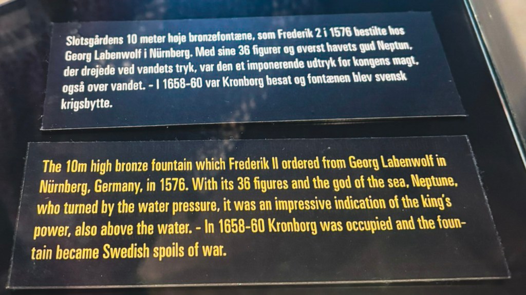
The Courtyard – Imagine the grandeur of the lost Renaissance fountain, melted down during the Swedish invasion of 1658.
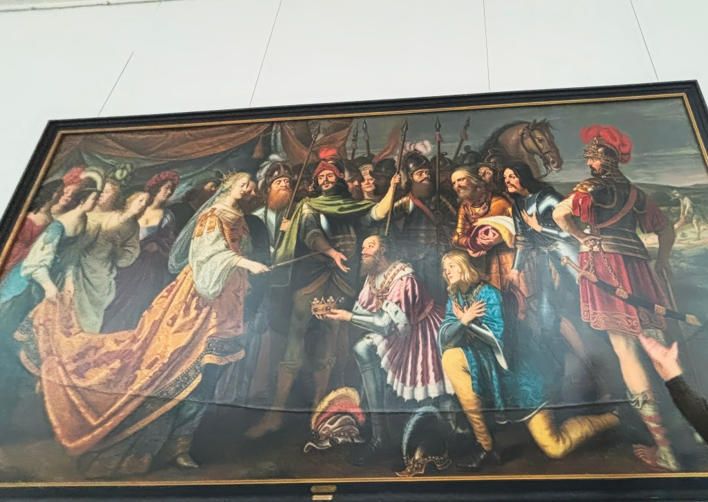
The Painting-Gerard van Honthorst’s 1640 oil painting “King Albrecht Hands Over the Swedish Crown to Queen Margaret I“
Row of cannons-rows of antique cannons outside the castle to watch over the Øresund Strait
For centuries, Denmark controlled the passage into the Baltic, collecting tolls from every ship that sailed by. At times, these taxes financed more than a third of the kingdom’s expenses—a reminder of Kronborg’s immense strategic importance.
The first castle on this site was built in the 1420s, and when King Frederik II expanded it after Denmark’s victory over Sweden in the late 1500s, he envisioned a Renaissance palace that would outshine Sweden’s Kalmar Castle. The result was Kronborg—literally “Crown Castle”—a symbol of Danish dominance in Scandinavia.
Fire, War, and Resilience 🔥
Though much of the castle’s interior was destroyed by fire in 1629, King Christian IV restored it with ornate ceilings and decorations that still bear his initials, “C4.” But Kronborg’s story took a darker turn in 1658, when Sweden invaded. The army pillaged the castle, looted its paintings, and even melted down the courtyard fountain into cannonballs and church bells. Despite this devastation, Kronborg endured—and today, it remains one of Europe’s most iconic strongholds.
Model of the courtyard fountain
Guardians of the Sound 🔊💥
Outside Kronborg Castle, rows of antique cannons still stand watch over the Øresund Strait, a powerful reminder of the fortress’s strategic importance. In its heyday, Kronborg controlled maritime traffic and collected the lucrative Sound Dues from passing ships. These cannons once defended the narrow waters between Denmark and Sweden, ready to fire in protection of royal interests.
Today, they serve a ceremonial role, often fired during commemorations and national holidays. The thunderous salute, paired with the sight of uniformed guards and the Danish flag flying high, connects visitors to the castle’s military legacy and the drama that once unfolded along its coastal walls.
Sacred Resilience in Stone ⛪
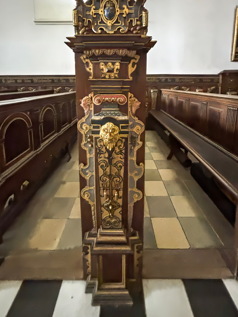
Among Kronborg Castle’s most remarkable features is its chapel, consecrated in 1582. This serene space is the only part of the castle that survived the devastating fire of 1629 intact, preserving its Renaissance character through centuries of turmoil. With intricately carved wooden pews, gilded details, and an ornate altar, the chapel reflects the grandeur of Frederik II’s vision and the craftsmanship of the era.
Ironically, while much of the castle’s interior was destroyed and later looted during the Swedish invasion of 1658, the chapel remained untouched. It continued to serve as a place of worship for royals and later soldiers when Kronborg became a military stronghold. Today, it stands as a rare, authentic reminder of the castle’s spiritual heart—offering visitors a quiet moment of reflection amid the fortress’s dramatic history.
Majesty in Stone and Splendor 🏰
Among the most awe-inspiring spaces in Kronborg Castle is the Great Hall, completed under Frederik II in the late 16th century. At over 60 meters long, it was one of the largest royal halls in Northern Europe and a dazzling stage for banquets, ceremonies, and diplomatic gatherings. Its soaring proportions, richly decorated ceilings, and grand windows reflected the king’s ambition to showcase Denmark’s wealth and dominance to visiting nobles and foreign envoys.
Ironically, while the hall’s magnificence symbolized Danish power, it too suffered during the fire of 1629 and the Swedish invasion of 1658, when many of its tapestries and furnishings were looted. Yet the hall was restored under Christian IV, who added Baroque flourishes that still impress visitors today. Standing within its vast expanse, you can almost hear the echoes of Renaissance feasts, Shakespearean drama, and centuries of royal intrigue—making the Great Hall a centerpiece of Kronborg’s enduring legacy.
Did you know? Looted Treasures of Kronborg 🏺⚔️
Kronborg’s grandeur was not only scarred by fire but also by war. When Sweden invaded in 1658, the army stripped the castle of many of its most precious treasures. Paintings, tapestries, and furnishings were carried off, while the magnificent courtyard fountain was dismantled and melted into cannonballs and church bells. According to our guide, the only painting left behind was the Gerard van Honthorst’s dramatic painting “King Albrecht Hands Over the Swedish Crown to Queen Margaret I”. A sword slash can be seen on this painting as a revenge from the Swedes showing the continued animosity between Danish and Swedish royals
Royal Power in Paint 🎨
Among Kronborg Castle’s artistic highlights is Gerard van Honthorst’s 1640 oil painting “King Albrecht Hands Over the Swedish Crown to Queen Margaret I.” This dramatic work captures the pivotal moment in 1389 when Margaret I defeated King Albrecht of Sweden and united Denmark, Norway, and Sweden under the Kalmar Union. Painted with Honthorst’s signature chiaroscuro, the scene emphasizes both the solemnity and grandeur of the transfer of power.
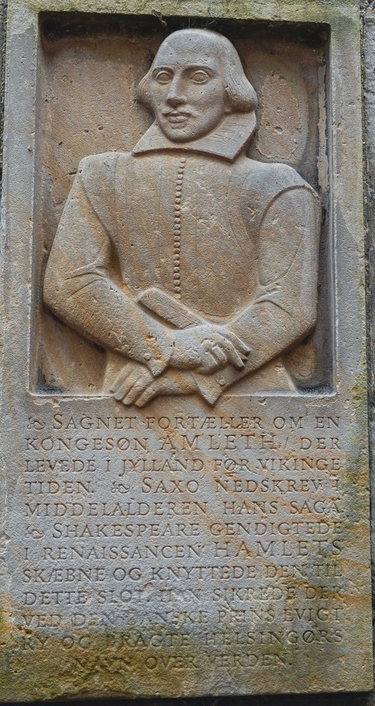
Hamlet’s Stage 🎭
Shakespeare immortalized Kronborg in Hamlet, setting the tragedy in Elsinore (Helsingør). While Shakespeare himself likely never visited, one of his actors had, which may explain the play’s uncanny accuracy in describing the castle. Standing in the grand halls, it’s impossible not to whisper the famous line: “To be or not to be, that is the question.”
Every summer, actors perform Hamlet within the castle walls, bringing the timeless drama to life in its original setting. There is a plaque in the front of the castle which recognizes Shakespeare’s role in making this castle immortal
Legends in the Casemates 🛡️
Deep down in the casemates of Kronborg Castle, you will find a mythical figure known as Holger Danske or Ogier the Dane, as he is also referred to. He is an important national symbol for the Danes, but the myth actually derives from Chanson de Roland, a principal work in French medieval literature.
The legend has it that Holger Danske is asleep deep down in the underground passages of Kronborg Castle’s casemates. He has been so for hundreds of years, and he will only wake up if Denmark is threatened by enemies, and he will wake up to defend his country. A Bronze statue was built in 1907, and the plaster model was based on the casemates of Kronborg, which became a very popular sight. In 1985, it was replaced by a concrete statue due to the damp climate in the casemates.
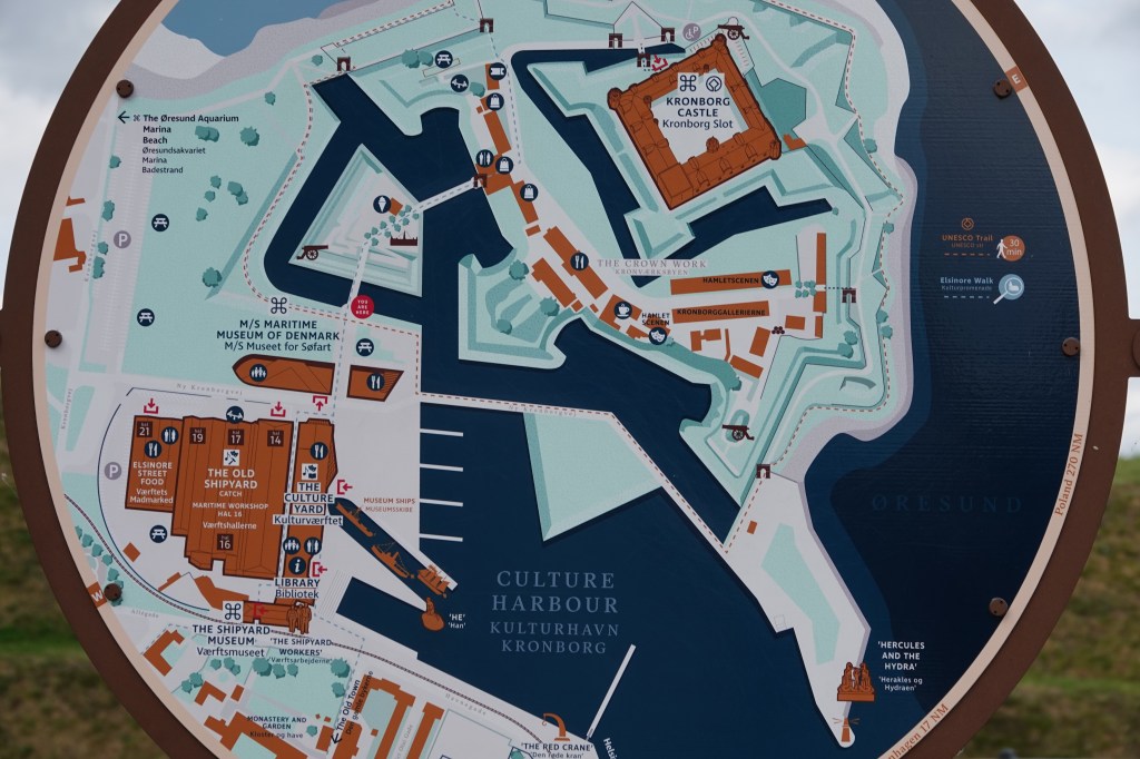
Explore Elsinore: Beyond the Castle 🏘️🌊
After your visit to Kronborg, make time to enjoy the vibrant town of Elsinore:
🏘️ Wander the old streets filled with colorful buildings and local charm
🍽️ Savor global flavors at Værftet’s international street food market
⚓ Dive into maritime history at the M/S Maritime Museum of Denmark
🐠 Meet sea creatures at the Øresund Aquarium
⛵ Sail the Sound with ForSea and enjoy dinner on the water
Getting There 🚆
Visiting Kronborg Castle is remarkably easy from Copenhagen:
Distance: 46 km north of the capital
Train: From Copenhagen Central Station to Helsingør (Elsinore) – about 45 minutes
Walk: A scenic 15–20 minute stroll from the station to the castle
This journey makes Kronborg an ideal day trip, combining history, culture, and coastal charm. I visited Kronborg Castle as part of a tour group with Hamlet Tours. Some of the photos I took of the castle are from the Ferry that goes between Helsingør to Helsingborg. You can combine the visit to Kronborg Castle with a visit to Helsingborg, Sweden. More about this here.
Final Thoughts on Kronborg Castle ✨
Kronborg Castle is more than stone walls and royal halls—it is a living chronicle of Denmark’s power, resilience, and cultural legacy. From its Renaissance grandeur financed by the Sound Dues, to the scars of fire and Swedish looting, the fortress embodies both triumph and tragedy. It is a place where Shakespeare’s Hamlet continues to echo through the courtyards, where Holger the Dane slumbers in myth, and where UNESCO recognition ensures its preservation for generations to come.
Visiting Kronborg is not just a journey into history—it is an immersion into stories of kings, queens, warriors, and playwrights that shaped Scandinavia and inspired the world. Whether you come for the art, the legends, or the sweeping views across the Øresund, Kronborg leaves you with a sense of awe and connection to centuries of drama that unfolded within its walls.
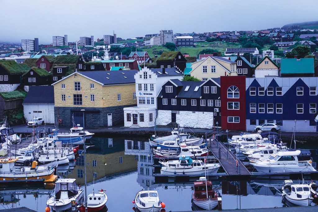
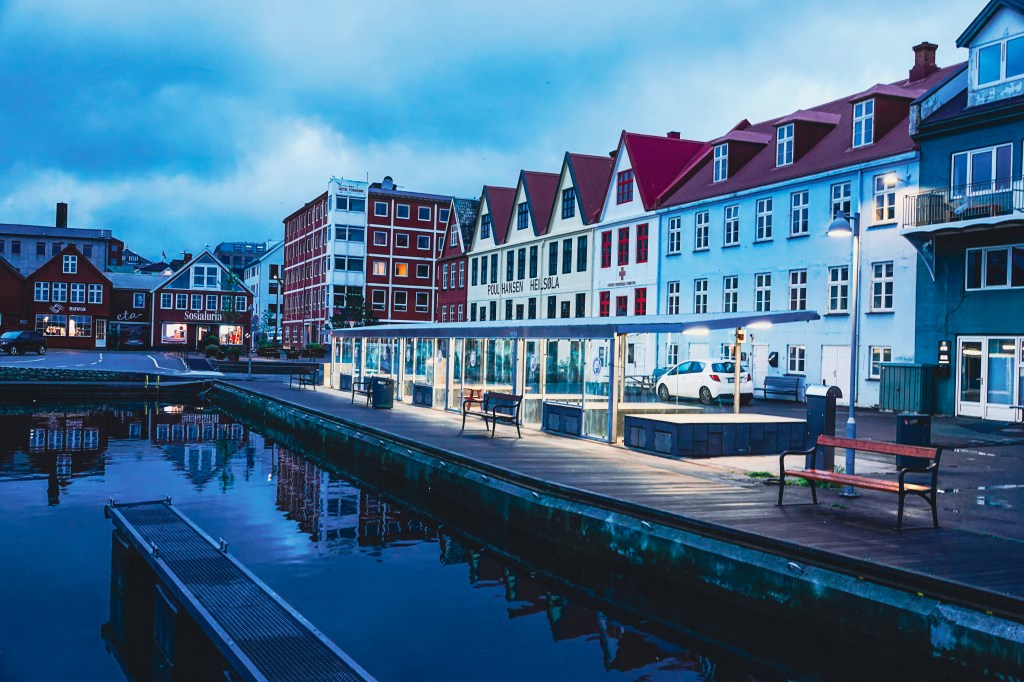
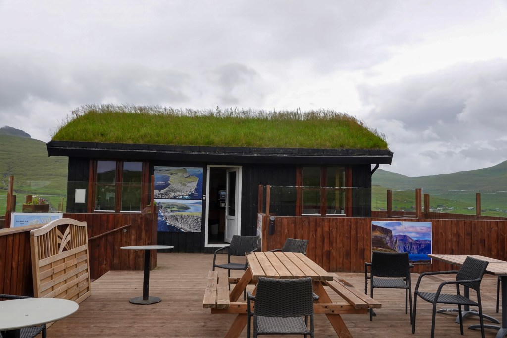
Tórshavn is the capital city and cultural heartbeat of the Faroe Islands. Despite its size, Tórshavn buzzes with cozy cafes, colorful turf-roofed houses, and a beautiful harbor. I stayed in the heart of the city in Hotel Hofnia and managed to walk everywhere. I loved how compact and walkable the downtown area was and I walked the downtown multiple times at all hours including at 4 AM on the first day (jet-lagged and couldn’t sleep). It is a very safe town. Tórshavn derives its name from Thor– one of the principal gods in Norse mythology. It also derives from the Scandinavian word “havn” for harbor. The name reflects the town’s Viking origins and its strategic coastal location
There is a lot to do in Tórshavn. Even though I spent only 3 days in these islands, staying in the heart of downtown allowed me to wander around this charming capital city. I managed to see some of the city’s highlights.
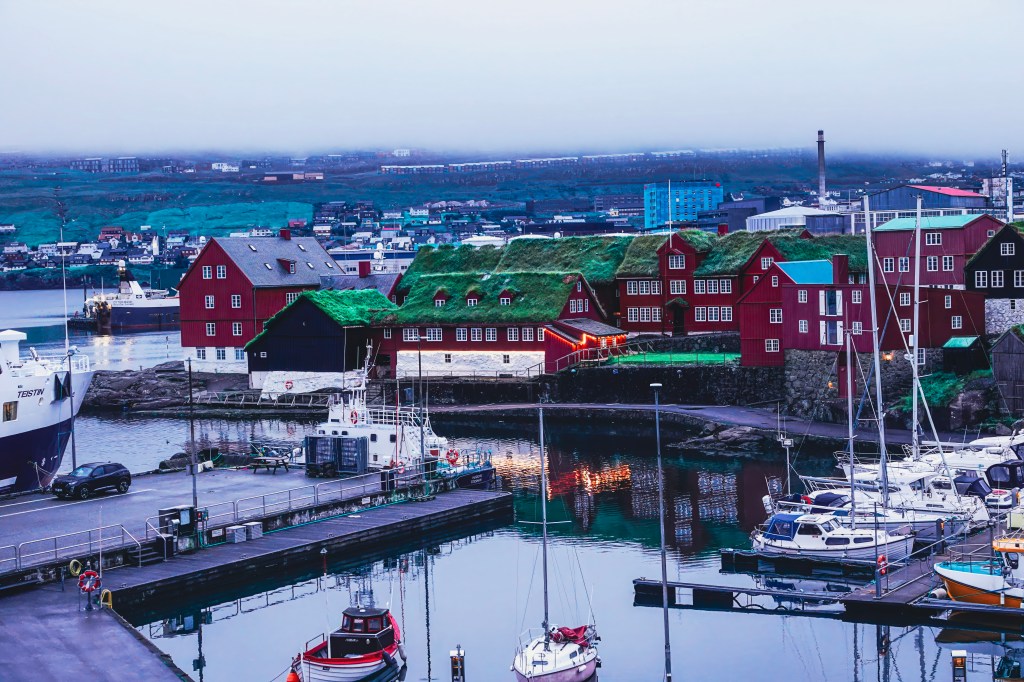
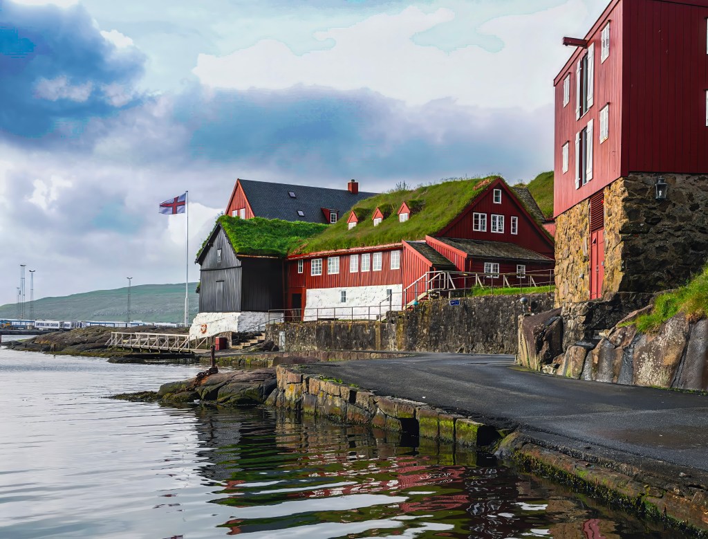
The colorful harbor front of of Tórshavn, , is a compact, scenic area defined by the historic Tinganes peninsula. The harbor area is divided into two parts, the eastern (Eystaravág) and western (Vestaravág) harbors. The eastern (Eystaravág) is the city’s commercial heart and a hub of activity. It is the functional side of the port where bus and ferry terminal, acting as the main public transport hub for the Faroe Islands. You can also see the Skansin fortress and the lighthouse on the eastern side. The western side of the harbor is dominated by cute cafes, restaurants, and shops.
Historic Tinganes peninsula
The windswept peninsula of Tinganes is more than just a picturesque assembly of turf-roofed houses. It is the beating heart of Faroese history. It represents one of the world’s oldest parliamentary meeting sites. As I wandered through the old town of Tinganes in Torshavn, I felt like I had stepped into a fairytale. The narrow lanes and wooden buildings were enchanting. Centuries of history whispered from every corner. For over a millennium, this rocky outcrop has been the island’s center for law and governance. Viking Age settlers first established their Ting (parliament) here around 825 AD. In the same narrow, cobbled lanes, the Faroese Home Rule government still meets. Viking leaders once convened the Althing here. Ministerial offices are housed in the iconic red-painted wooden buildings that date back to the 16th and 17th centuries.
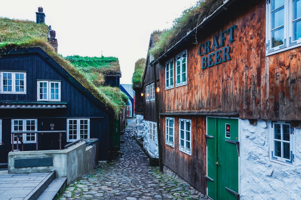
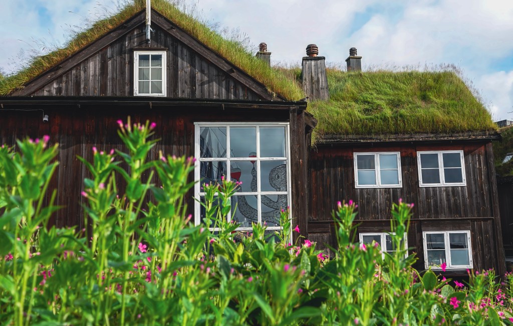
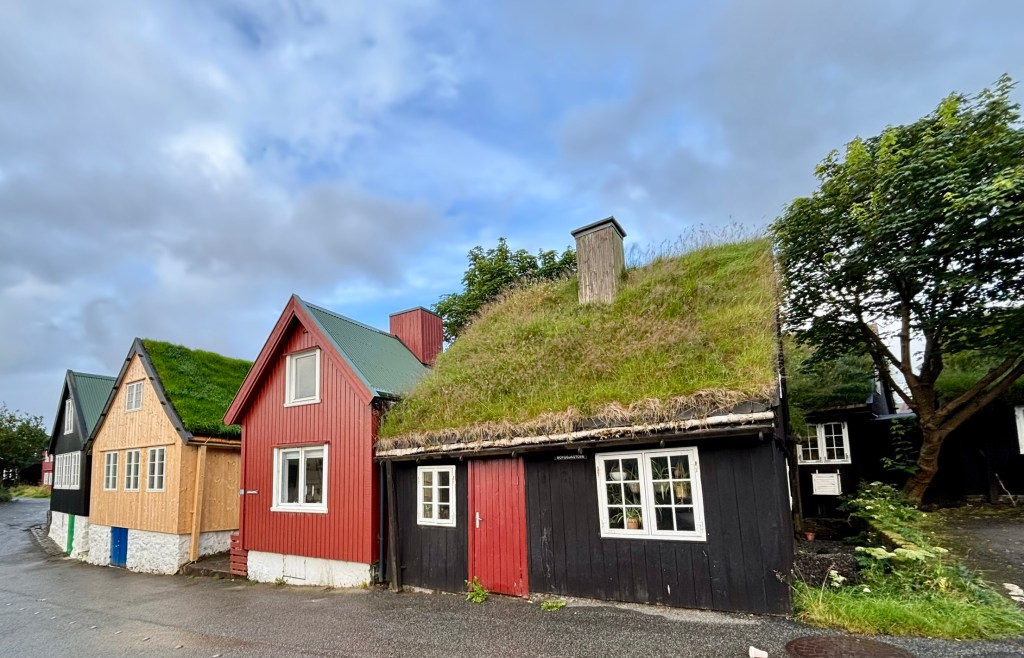
The Timeless Streets of Undir Ryggi: Tórshavn’s Oldest Quarter
Undir Ryggi is a charming, historic neighborhood in Tórshavn, forming part of the city’s Old Town alongside the Reyn district. Nestled on a hillside near the harbor, the neighborhood is defined by its small, traditional Faroese houses. Many of these houses are centuries old. They are still inhabited today. The buildings are often tarred black with crisp white window frames. They feature classic grass roofs. This creates a wonderfully picturesque and time-honored scene. Visitors can explore the narrow lanes and passageways. These paths are winding, cobbled, and crisscross the area. They offer a peaceful glimpse into Tórshavn’s past. Undir Ryggi is easily accessible from the harbor.
Havnar Kirkja: The Historic Heartbeat of Tórshavn
Located right behind the Hotel Hafnia, I could see this church every morning from the window. This church dominates the harbor skyline and the surrounding area,
Standing proudly by the harbor, Tórshavn Cathedral (Havnar Kirkja) is one of the Faroe Islands’ most treasured landmarks. It is a must-see for visitors exploring the capital. Built in 1788, this elegant white church stands with a striking grey roof. It features a golden clock tower. It is the second-oldest church in the Faroe Islands still in use.
I didn’t get a chance to see the inside. Based on what I read, interior is filled with maritime touches. Ship models hang from the ceiling. Warm wooden pews reflect the islands’ deep seafaring roots. The cathedral remains the seat of the Bishop of the Faroe Islands. It continues to host services. It also hosts concerts and community gatherings.
Skansin Fort: Tórshavn’s Historic Guardian of the Sea
From its grassy perch overlooking Tórshavn harbor, Skansin Fort is a living chronicle of the Faroe Islands’ layered past. Built in 1580 to fend off pirate raids, this strategic outpost has weathered centuries of change. It survived a destructive encounter with French pirates. It also played a pivotal role as a British military headquarters during World War II. As you stroll the ramparts, you can examine the historical cannons—some from the Danish trade monopoly, others powerful 5.5-inch naval guns left by the British—that still stand guard over the sea lanes. The highlight, however, remains the stunning panoramic views. With the iconic red-and-white lighthouse as your focal point, you can take in sweeping vistas of the bustling port, the picturesque town, and the distant, rugged outline of Nólsoy island on the horizon
Visit Kongaminnið Monument
The photo above shows the view of the Kongaminnið monument from my room. I didn’t visit the monument, but it offers a great view of the city and the harbor. The Kongaminnið monument is a basalt obelisk. It was erected in 1882 to honor Danish King Christian IX’s visit to the Faroe Islands in 1874. This visit was the first by a Danish monarch. The king’s visit to Tórshavn had some dramatic moments. During the welcome speech, the mayor fainted and tragically died in front of the King and the crowd. King Christian IX was deeply affected and supported the mayor’s widow financially for the rest of her life.
Gamli Bókahandil and Paname cafe
Officially known as H.N. Jacobsens Bókhandil, Gamli is the oldest bookstore in the Faroe Islands. It is also a cultural gem in the heart of Tórshavn.
The shop was founded in 1865 by Hans Nicolai Jacobsen. He was a bookbinder and cultural advocate. The shop began in the historic Gongin street. It later moved to its current location in Vaglið square. Here, it resides in a charming red building with a turf roof.
Today, Gamli Bókahandil offers a wide selection of books in Faroese, Danish, and English. It also provides stationery, gifts, toys, and art prints. I bough postcards and stamps and mailed them to my family and friends from the postbox located in the bookstore. I bought the book “Land of May be” by Tim Ecott here (This is a popular book about Faroese culture and heritage). The book store is attached to another of my favorite places in Torshvn, the Paname Cafe. Paname Café blends French interior design with Faroese hospitality. It’s a family-run café offering homemade pastries, sandwiches, tapas plates, and organic coffee and tea, along with a curated selection of French wines and local beers
The National Museum of the Faroe Islands
The National Museum of the Faroe Islands (Tjóðsavnið) in Tórshavn offers a rich and immersive journey through the islands’ natural and cultural history. I didn’t get a chance to check this place out, but it comes highly recommended as one of the must-visit places
Located at Brekkutún 6, the museum features a permanent exhibition that spans geology, botany, zoology, archaeology, and folk life. Visitors can explore the volcanic origins of the islands, view native bird and marine life, and discover artifacts from the Viking Age and Middle Ages, including bone combs, beads, and farming tools.
One of the museum’s most treasured displays is the Kirkjubøstólarnir — intricately carved pew ends from the 15th century, originally part of St. Olav’s Church in Kirkjubøur. These pieces are considered national treasures, reflecting the craftsmanship and religious heritage of medieval Faroese society.
Restaurants of Tórshavn
I stuck with mostly Cafe Kasper, which is right next to Hotel Hofnia, and had some great options for vegans and vegetarians. Another restaurant I tried was Etika, a sushi restaurant right opposite Hotel Hofnia. Here are a few others that are quite popular in the downtown and surrounding area
KOKS: Michelin-starred and world-renowned, KOKS serves a tasting menu rooted in Faroese heritage, including fermented lamb, seaweed, and local seafood.
Áarstova is set in a historic turf-roofed house. This cozy spot specializes in Faroese lamb and fish dishes. The ambiance is rustic.
Ræst: A unique restaurant dedicated to traditional Faroese fermented cuisine, offering bold flavors in a timber-clad setting.
Barbara Fish House: Located in the old town of Tinganes, this charming seafood restaurant offers fresh fish, mussels, and Faroese-style sushi.
Etika Sushi is the only sushi restaurant in the Faroe Islands. It blends Japanese techniques with Faroese ingredients, such as salmon and sea urchin.
Fríða Kaffihús: A cozy café perfect for coffee, tea, and light snacks, with a relaxing vibe and great pastries.
Húsagarður: A stylish European grill offering seasonal menus and wine pairings, ideal for a refined evening out.
Katrina Christiansen: A solo-diner-friendly restaurant with a vegan menu and affordable Faroese dishes.
Roks: KOKS’ more affordable sister restaurant, offering high-quality Faroese cuisine in a relaxed setting.
Irish Pub Tórshavn: A lively spot for beers, pub food, and live music — great for socializing
Final Thoughts: Why Tórshavn Captivates
Tórshavn may be one of the smallest capitals in the world, but it pulses with history, hospitality, and heart. From Viking-age parliament sites to turf-roofed homes and cozy cafés, every corner of this walkable city invites exploration. Staying at Hotel Hafnia placed me in the center of it all. It allowed me to wander at all hours. I could soak in the harbor views and discover the soul of the Faroe Islands.
Whether you’re sipping organic coffee at Paname Café or browsing books at Gamli Bókahandil, hiking up to Skansin Fort, or dining at the world-renowned KOKS, Tórshavn offers a rich blend of tradition and modernity. Even in just three days, I felt deeply connected to the rhythm of this city — its quiet mornings, dramatic skies, and welcoming people.
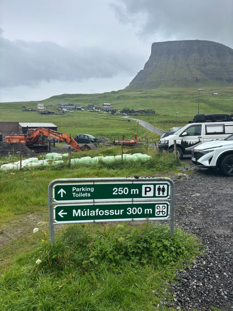
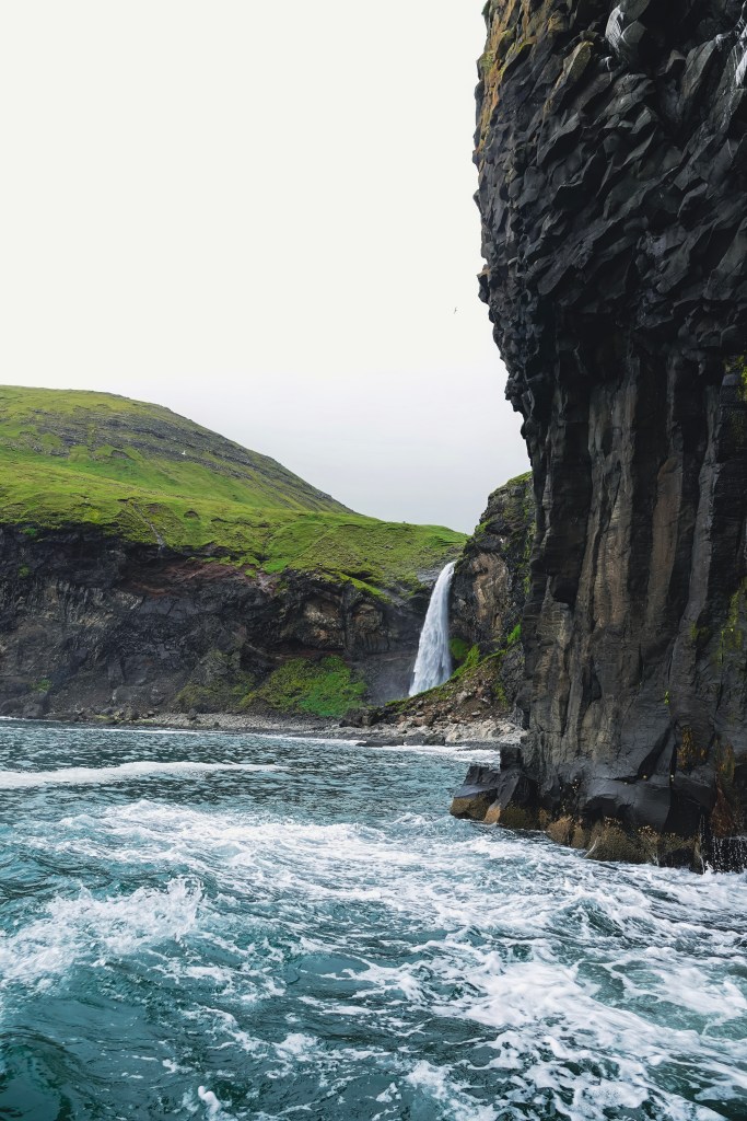
Múlafossur Waterfall is a dreamy waterfall tucked away on the rugged western edge of Vágar Island in the Faroe Islands. The waterfall plunges dramatically into the Atlantic Ocean, surrounded by cliffs and a tiny, charming village of Gásadalur. I got to see the waterfall twice. First, I saw it from the ocean when I was on the Classic Drangarnir Sea Arch Boat Tour. Then, I saw it again from the land after visiting the Lake above the ocean. I also visited the village of Bøur. It is one of my favorite villages in the entire Faroe Islands. Both the sea views and the land views offer different perspectives of both the waterfall and the villages.
Múlafossur: The Promontory Waterfall
With a drop of 60 meters (200 feet), Múlafossur is the Faroe Islands’ most iconic natural wonder. Its name translates to “Promontory Waterfall.” The name is fitting as it cascades off a cliffside directly into the tempestuous sea below.
Gásadalur: The Goose Valley
Gásadalur was once accessible only by hiking over the steep mountain passes. Now, the village welcomes visitors through the Gásadalstunnilin tunnel(Built in 2006). This makes the journey far easier— but no less magical. With about 20 residents and 25 houses, this remote village offers a rare glimpse into traditional Faroese life. You can actually stay in this village. There are 2 options. One is Múlafossur Cottages, located next to the stream. The other one is Hjalgrímsstova, part of the modern sheep farm Gásadalsgarðu.
The name Gásadalur means “Goose Valley,” and the charm here is undeniable. A cozy café and guesthouse serve locally sourced lunches, cakes, and coffee. These treats are perfect for warming up after a brisk walk to the waterfall.
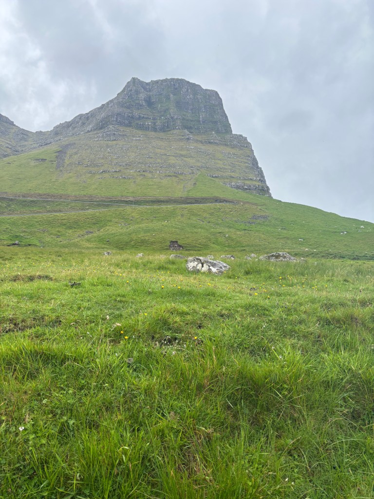
Mountains That Guard the Valley
Gásadalur is cradled between two majestic peaks:
Eysturtindur (“The Peak to the East”) rises to 715 meters (2346 feet)
Árnafjall, the highest mountain on Vágar, reaches 722 meters (2368 feet)
These mountains not only add drama to the landscape but also serve as silent sentinels, watching over the village and its waterfall.
When to Visit
Gásadalur and Múlafossur can be visited year-round. Summer offers longer daylight hours and milder weather, while winter cloaks the village in mist and mystery. No matter the season, the waterfall’s roar and the village’s quiet beauty promise a moment of awe.
Whether you’re chasing waterfalls or seeking solitude, Múlafossur and Gásadalur deliver both. You can combine a visit to the village and the waterfall with a visit to the village of Bøur
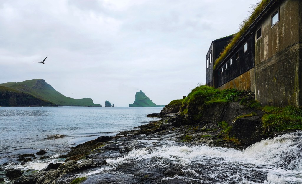
Bøur: The Coastal Hamlet with Legendary Views
Bøur is just a short drive from Vágar Airport. It lies along the same stretch of coast as Gásadalur. Bøur is a tiny village steeped in history and natural beauty. Around 70 residents live in Bøur. It is famous for its picturesque turf-roofed houses. These houses are clustered near a small beach and a charming 19th-century church.
From Bøur, visitors enjoy breathtaking views of the jagged islets Tindhólmur and Drangarnir, iconic sea stacks that have inspired countless photographs and paintings. The village’s peaceful atmosphere and scenic surroundings make it a favorite stop on Faroe Islands sightseeing tours. Village of Bøur, has couple of restaurants and cafes that you could and enjoy a meal. We stopped here and had a picnic lunch on the black sand beach after out visit to the Mulafossur and took some great photos of Drangarnir from the beach.
Public Transport & Driving
From Vágar Airport: Both Bøur and Gásadalur are easily accessible by car, making them ideal stops for travelers. The drive to Bøur takes about 15 minutes, allowing you to enjoy stunning views along the way. Continuing on to Gásadalur adds another 5 minutes. This brings the total travel time to 20 minutes through the scenic Gásadalstunnilin tunnel. The tunnel offers a unique experience as you pass beneath the mountains.
Road Conditions: Roads are well-maintained but narrow and winding. Drive cautiously, especially in foggy or wet conditions.
Parking: Designated parking areas are available near both villages. From the Gásadalur parking lot, it’s a short walk to the Múlafossur viewpoint.
By Bus:
Bus 300 from Vágar Airport to Sørvágur
Bus 350 from Sørvágur to Bøur (runs 3x/day on weekdays)
How to Visit: By Boat
Boat Tours: Several local operators offer boat tours from Sørvágur or Vágar harbor. These tours cruise along the coast and give stunning views of Múlafossur, Drangarnir, and Tindhólmur from the sea.
Highlights:
See Múlafossur waterfall from below as it crashes into the ocean.
Sail past dramatic cliffs and sea stacks.
Spot puffins and seabirds nesting on nearby islets.
Season: Most boat tours run from May to September, weather permitting.
The Postman’s Trail: A Historic Hike Between Bøur and Gásadalur
Before the tunnel was built in 2004, Gásadalur was completely isolated, accessible only by boat on calm days or by foot over the mountains. The most famous route was the Postman’s Trail, a rugged path that connected Bøur to Gásadalur.
Distance: ~5 miles round-trip
Duration: 3.5 to 4.5 hours
Difficulty: Moderate to challenging (steep climbs, uneven terrain)
Trailhead: Just past Bøur, near the tunnel entrance (look for cairns and a narrow dirt path)
Summits Nearby: Mt. Rógvukollur (464 m) and Knavin (485 m) offer optional detours with panoramic views
The postman hiked this trail three times a week, delivering mail to Gásadalur’s residents. Along the way, he would pass dramatic cliffs and windswept ridges. He would eventually descend into the valley where Múlafossur Waterfall roars into the sea. It was a view he knew well.
Today, hikers can retrace his steps and experience the Faroe Islands as they were before modern roads. It’s a journey through history, solitude, and raw nature.
Where to Stay: Gásadalur & Bøur
Whether you’re seeking solitude by the sea or a warm cottage nestled beneath misty mountains, both villages offer unforgettable accommodations.
🌿 Gásadalur Stays
Lundi Cottage – Turf Cottage by Múlafossur Waterfall A guest favorite on Airbnb, this charming turf-roofed cottage sits right beside the famous waterfall. Expect sheep, birds, and highland cows as neighbors, plus views that feel like a painting.
Múlafossur Cottages These well-crafted holiday homes offer spacious interiors, warm ambiance, and unbeatable proximity to the waterfall. Ideal for relaxing after a day of hiking or sightseeing.
Gásadalur Apartments @ World Famous Waterfall Air-conditioned apartments with balconies and full amenities, located steps from the waterfall. A perfect blend of comfort and location.
Nearby Options in Sørvágur & Sandavágur If Gásadalur is fully booked, nearby towns offer excellent alternatives:
Guesthouse Hugo – Cozy, social atmosphere with sea views
Cottages by the Sea – Waterfront serenity with mountain views
Giljanes Camping & Hostel – Budget-friendly with shared kitchen and lounge
🏡 Bøur Stays
The View to Drangarnir, Tindhólmur & Mykines These are a cluster of four traditional Faroese turf-roofed houses. They are built to blend into the landscape. These homes offer panoramic views of the famous sea stacks and are among the highest-rated stays in the Faroe Islands.
Airbnb Options in Bøur Bøur features several unique rentals with rustic charm and modern amenities. Many offer full kitchens, cozy living spaces, and direct views of the ocean and nearby islets.
Nearby Sørvágur Accommodations Just a short drive away, Sørvágur offers:
Løðupackhouse – Historical Warehouse – A renovated 100-year-old harbor house
Perlan Apartments – Sea-view apartments with full kitchens
Pouls Airport Guesthouse – Convenient for travelers, with car rental options included
Skarðsáfossur: The Hidden Waterfall of Vágar
While Múlafossur steals the spotlight, Skarðsáfossur is just a short distance away. It is a lesser-known but equally breathtaking waterfall. It tumbles from the cliffs onto a small black stone beach. This secluded cascade is positioned between Bøur and Gásadalur. It offers a more intimate and wild experience for those willing to seek it out.
Location & Landscape
Coordinates: Roughly 2 km west of Bøur, near the tunnel entrance to Gásadalur
Setting: Rugged cliffs, black stone beach, and panoramic views of Tindhólmur, Drangarnir, and the skerry Akranessker
Wildlife: Puffins and seals are often spotted in the area
The waterfall is best viewed after rainfall, when its flow is strongest and most dramatic.
Best Way to Visit: By Boat
Because the land surrounding Skarðsáfossur is private property, the best and most respectful way to see it is from the sea:
Boat Tours: Depart from Sørvágsfjørður and cruise past Skarðsáfossur, Drangarnir, and Tindhólmur
Experience: Boats can get close enough to hear the crashing water and feel the spray
Recommended Tour: Drangarnir Boat Tour includes Skarðsáfossur as a highlight
Land Access: A Rugged Adventure
While not officially marked, adventurous hikers sometimes approach the area from land:
Trailhead: Just before the tunnel to Gásadalur, near Bøur
Route: Hike down toward the ocean, aiming for the skerry Akranessker
Terrain: No visible path; grassy fields used for sheep herding, rocky coastline, and steep descents
Caution: Slippery rocks and private land—respect boundaries and avoid trespassing
Bluegate – Drangarnir & Múlafossur Boat Tour
Highlights: A 60–75 minute tour originates from Sørvágur marina. On this boat tour you will visit Bøur village, Múlafossur waterfall, Tindhólmur islet, and the Drangarnir sea stacks. Weather permitting, guests may sail through Drangarnir’s sea arch. Small boat size (12 passengers) ensures a personal experience. In the summer months, you may be able to see some puffins.
📌 Meeting Point: Sørvágur marina
☎️ Phone: 780800
🌐 Website: bluegate.fo
Seatravel – Exclusive Drangarnir Boat Tours
Highlights:1.5 hour tours from Sørvágur to Drangarnir, Múlafossur, Tindhólmur, and Akrans. Focuses on intimate small groups (max 16 passengers), guided by experienced captains.
📌 Meeting Point: Sørvágur marina
🌐 Website: seatravel.fo
Final thoughts
Exploring Múlafossur and the village of Gásadalur is like stepping into a living postcard—where nature’s drama meets quiet village charm. From the iconic waterfall plunging into the Atlantic to the serene beauty of Bøur and the tucked-away Skarðsáfossur, this corner of the Faroe Islands offers a rare blend of accessibility and mystery.
Whether you’re chasing waterfalls, hiking cliffside trails, or simply soaking in the silence, this guide is your invitation to slow down and let the landscape speak. The Faroe Islands aren’t just a destination—they’re a mood, a rhythm, a reminder that the most unforgettable places are often the ones that feel untouched.
So pack your layers, charge your camera, and bring your sense of wonder. Gásadalur and its neighbors are waiting.
The desktop background that set me on an adventure to the Faroe Islands…. You might have seen this lake as a desktop background. Once I saw it, I knew I had to visit. The entire trip was planned with a hike to the Lake above the ocean as the primary focus.
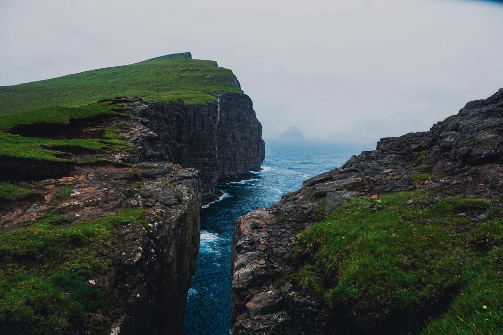
Lake Sørvágsvatn, the largest lake in the Faroe Islands, covers an impressive 3.4 square kilometers and appears to hover enchantingly over the North Atlantic Ocean from the dramatic heights of Trælanípa Cliff. This optical illusion is caused by the elevation of the lake compared to the sea. At its end the stunning 30-meter-high Bøsdalafossur waterfall that cascades gracefully down into the ocean. This picturesque viewpoint not only showcases the waterfall, but it also offers an awe-inspiring view of the sea stack Geituskoradrangur.
* The lake is known by two names, Sørvágsvatn and Leitisvatn, due to local preferences. Sørvágsvatn is preferred by the people of Sørvágur, while Leitisvatn is favored by those in Miðvágur and Sandavágur.
Hiking guidelines and starting point
You need to pay to do this hike as the lake and the cliffs sit on private property. There is a dirt parking lot at the beginning and a reception hut. You can buy tickets as well as get snacks and souvenirs from this small shop. More information can be found at the landowners’ web page.
The gate is open 24/7. If you want to do an early morning sunrise or sunset hike, you can still do the hike and pay later. (Honor system). It’s an easy hike with minimal elevation gain. However, wear proper shoes as the muddy path can get slippery when it’s raining.
How to get to Sørvágsvatn/ Leitisvatn lake
Public Bus Travel from Tórshavn
The main bus terminal in Tórshavn is known as Farstøðin. It serves public blue buses. These buses run between Tórshavn and villages on Vágar Island (where the lake is located).
You can take a bus from Tórshavn to nearby villages such as Miðvágur or Sandavágur. These villages serve as common starting points for hikes to the lake.
The ride from Tórshavn to these villages generally takes around 40 minutes to an hour. This includes travel through the underwater tunnel that connects Streymoy (Tórshavn’s island) and Vágar Island.
Self Drive/ Car
You can drive to the dirt parking lot, pay the fee at the entrance, and hike on your own. It is a straightforward route that can be easily done on your own.
Private guided tour
You can hire a private guide for this tour. I took a guided hike with JH Tours, which is run by Johan and his family. I highly recommend JH tours for all tours around the Faroe Islands. You can reach him at Faroestours@gmail.com or (+298)28 28 00. They can plan 6-7-day tours that include all the highlights of the Faroes. You can book a local lunch cooked by Johan’s mother, Jona. This way, you can have an authentic Faroese culinary experience at their house.
This tour also includes visiting Múlafossur Waterfall and the village of Gásadalur. We also stopped at the village of Bøur and had a packed picnic lunch on the black sand beach with the views of Tindhólmur and the stacks Drangarnir.
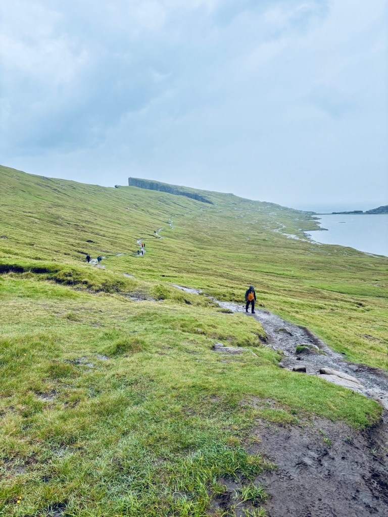
Key Highlights on the hike
From the reception, the hike is pretty simple and straightforward. You can stop at various view points. Some of the most impressive view points include:
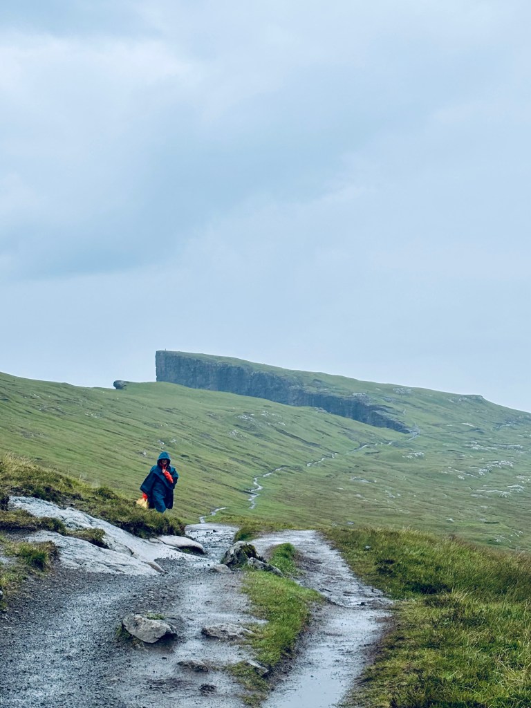
Trælanípa (Viewpoint 1 and 3)
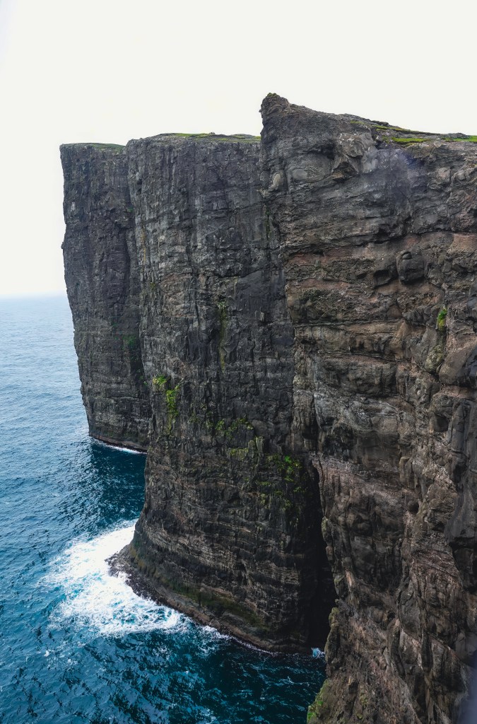
Trælanípa is a magnificent perpendicular rock wall. It juts an impressive 142 meters upwards out of the vast expanse of the sea. This creates a breathtaking sight for all who visit. The name Trælanípa translates to Slave Cliff, a chilling reminder of its dark history. It derives its name from the Viking Age, a time when the harsh realities of survival dictated brutal outcomes. During this period, old and sick slaves who were no longer deemed useful to their masters were callously pushed off the mountain, offering a stark reflection of the values and harshness of that era.
If the cliffs look familiar, it has been used in the Peter Pan and Wendy movie. You can check out more locations in the Faroe Islands that have been shown in the film here.
Lake above the ocean (viewpoint 2)
Continuing on the path, you will take a set stairs to get to the view point of Lake above the ocean. There is a small sign that shows where the best point to stand for the best photos. It was a rainy and cloudy day, but still I managed to get a few decent shots.
Bøsdalafossur Waterfall (Viewpoint 4)
Continue down from the viewpoint of the lake above the ocean. You will have to do some rock scrambling to reach the Bøsdalafossur Waterfall viewpoint. Be careful, as the stones can be slippery especially after rain.
Bøsdalafossur Waterfall falls dramatically from Lake Leitisvatn into the North Atlantic Ocean. It flows from an impressive height of 30 metres (98 feet) above sea level. This creates a stunning visual spectacle that captivates nature lovers and adventurers alike.
From viewpoint 4, you can also see Geituskorardrangur is a free-standing rock wall. This rock formation towers 116 metres (380 feet) above sea level.
Other interesting things on the hike
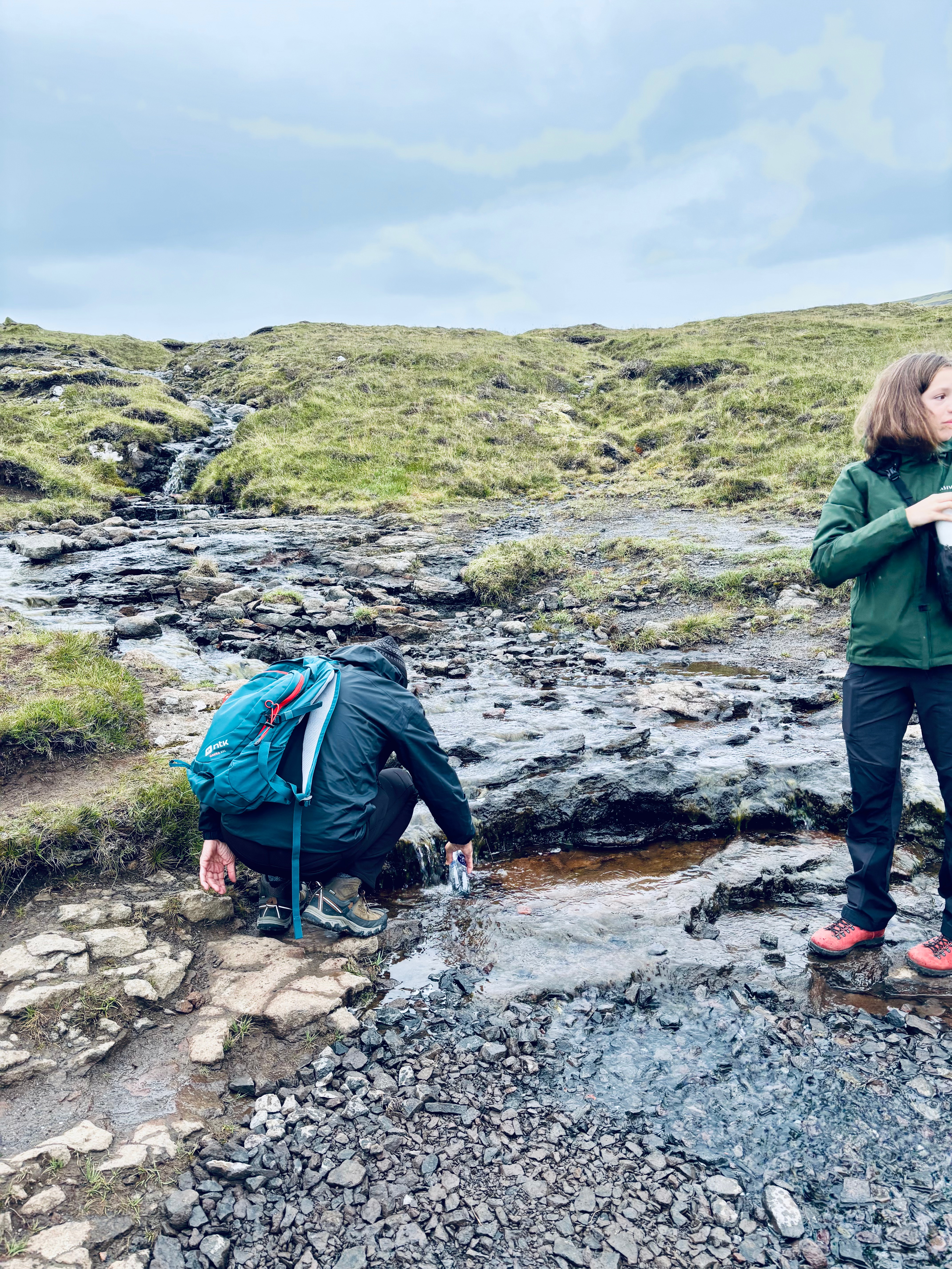
The whole hike is next to the Lake. You will see waterfalls on the way, especially after the rain. These spring waters are safe to drink but make sure you will bottles from the flowing part and not the stagnant water. Our tour group empties our water bottles and fills them with refreshing spring water.
Final thoughts
Hike to Lake above the ocean is a very easy hike with tremendous rewards. This hike can be easily combined with nearby attractions. These include visiting the village of Bøur, Múlafossur Waterfall, and Gásadalur. You can also combine this trip with the boat tour of Drangarnir & Múlafossur. Alternatively, consider the Drangarnir Hiking Tour, especially if you have a car, which gives you more flexibility to explore. Also, stop by the statue of Nix at the other end of the lake, close to the airport.
If you’re traveling in Chile, be sure to explore the breathtaking Atacama Desert! You’ll be amazed by the incredible diversity of landscapes, from sparkling lakes and expansive salt flats to stunning canyons, bubbling geysers, graceful flamingos, and adorable alpacas. With so many captivating places to discover, every moment will be an exciting adventure! We explored this amazing place by using San Pedro Atacama as our base, a charming adobe town with dirt roads and a stunning landscape.
Quick Summary:
What we did: Spent 2 days in San Pedro Atacamam and did self-guided tours( Ideal would be 3-4 days to cover everything)
Where we stayed :Hotel Kimal Domingo Atienza 452, San Pedro de Atacama, Antofagasta,
Where we ate: Many restaurants close to the hotel on the main street
Things I wish I had known before traveling to San Pedro Atacama
This unique region, known for its stunning landscapes and rich cultural heritage, offers visitors a wide range of activities, including hiking, stargazing, and exploring ancient petroglyphs. However, the various attractions in the Atacama Desert are spread out and managed by either local tribes or the Chilean government. Some attractions allow cash payments at the entrance, while others require online reservations, which can be confusing for first-time visitors. We found it difficult to navigate all the various requirements and get the best out of our visit to Atacama; therefore, taking a guided tour can provide valuable insights and help maximize your experience is advised. Knowledgeable guides can share fascinating stories about the local flora, fauna, and historical significance of the area, making your visit truly unforgettable. Check out denomades.com for customized tours tailored to your length of stay, ensuring that you can fully immerse yourself in the beauty and wonders of Atacama.
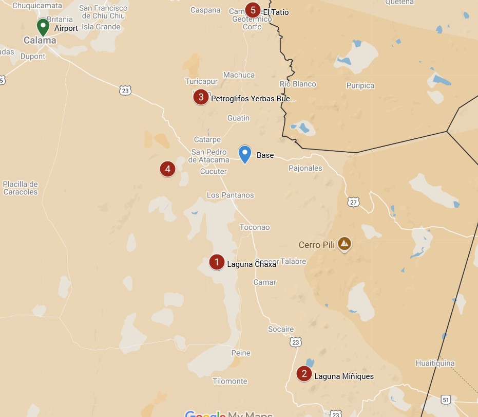
Tickets to various attractions and where to buy them
The full moon affects the tours. No tours are offered in and around the full moon
Rainbow valley
$5000
Check with a tour operator. Not much info available
None
Check with a tour operator. Not much info avialable
Petroglyphs of Yerbas Buenas
$5,000
$5,000
Cash at the entrance
None
Check with a tour operator. Not much info available
How to get to San Pedro Atacama
The most common way to get to San Pedro de Atacama is from Santiago to the city of Calama, and then head towards San Pedro. El Loa (CJC airport), located in Calama, about 100 kilometers northwest. It receives regular flights from Santiago and some services from other cities in Chile.
How long does the drive from Calama to San Pedro de Atacama take? The driving distance between Calama and San Pedro de Atacama is 100.5 km via Route 23. It takes about 60-90 minutes to drive this distance.
For more information on how to reach San Pedro Atacama and bus options, check this webpage.
Things to do in San Pedro Atacama
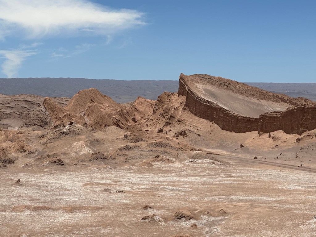
Experience the unique landscape of Valle de la Luna (Moon valley)
Valle de la Luna
The Valle de la Luna is named after its lunar-like landforms eroded by eons of flood and wind, creating a breathtaking landscape that captivates all who visit. This natural wonder is located approximately 15km west of San Pedro de Atacama, nestled at the northern end of the Cordillera de la Sal. It is a stunning mountain range noted for its unique geological formations. The valley is not only a feast for the eyes but also forms part of the Reserva Nacional Los Flamencos, a protected area that is home to a diverse array of flora and fauna. Visitors to Valle de la Luna can marvel at the dramatic contrasts of colors and textures, especially during sunset when the landscape transforms into a surreal palette of oranges and purples, offering a truly unforgettable experience.
You can pre-book your tickets hereor take an organized tour from one of the tour operators in San Pedro Atacama. Sunset is the time when most like to see Moon Valley and hence the busiest. Take lots of water, a hat, and sunscreen while visiting Moon Valley, as it is very dry and hot.
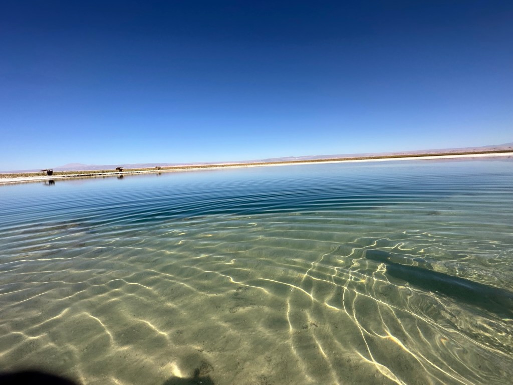
Float on Water in Cejar and Piedra Lagoons
Located 18 km east of San Pedro de Atacama, these lagoons are authentic hidden gems in the heart of the vast and breathtaking desert. With saline content similar to that of the Dead Sea, visitors can swim or float effortlessly in the warm, inviting waters. The facility is very well maintained, featuring clean showers and restrooms. This is one of our favorite places we visited in the Atacama Desert, a perfect retreat to experience the natural beauty and tranquility of the region.
Renowned for their striking beauty and unique ecosystem, both lagoons are under the careful management of the Atacameña Indigenous Community of Solor, who have inhabited this area for generations. Visitors can immerse themselves in the stunning landscapes and diverse wildlife that thrive in this arid environment. However, there are specific times when the lagoons are open to the public or tour operators, ensuring that the natural habitat is preserved and respected. For those eager to explore this enchanting destination, check here for the timing and tickets, and prepare for an unforgettable experience in one of nature’s truly remarkable settings.
Stargaze in one of the most beautiful night skies
San Pedro de Atacama is a great place for stargazing! The Atacama Desert has some of the clearest skies due to its high altitude, low humidity, and little light pollution. You can join tours that provide telescopes to see stars, planets, and galaxies. Some tours also include astrophotography and talks about space. The area has top observatories like Paranal and La Silla, which help with global astronomy projects. Unfortunately, we couldn’t take any tours because we visited during the full moon, which isn’t good for stargazing, and no tours were available. Check here for available tours.
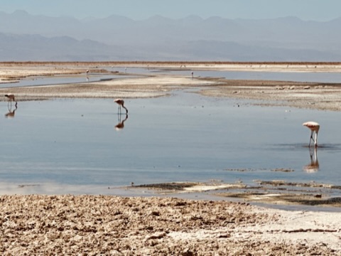
Go bird watching at Los Flamencos National Reserve-Laguna Chaxa
The Chaxa Lagoon is located at a central point of the Atacama Desert, an expansive and strikingly beautiful region known for its arid landscapes and unique ecosystems. It is situated just 7 km away from the charming village of Toconao and a little less than 50 km from San Pedro de Atacama, making it an accessible destination for both tourists and locals alike. This captivating area belongs to the Protection System of wild areas of CONAF. It is a vital part of the Flamingos National Reserve, which aims to safeguard the rich biodiversity found in the region. The lagoon attracts a variety of avian species, but it is probably one of the best places in Chile to see flamingos in their natural habitat. Visitors will find a couple of well-marked trails that meander through the reserve, allowing them to walk and observe the flamingos closely while enjoying the serene beauty of the landscape. Most people suggest going at sunrise to witness the stunning spectacle of the birds as they take flight under the rising sun, but it’s important to note that the park is not open until 8 AM, so plan accordingly.
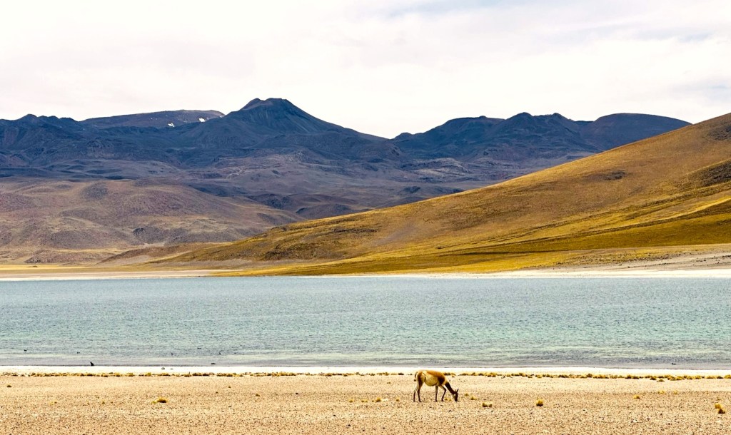
Viist Altiplanic lagoons- Miscanti and Miñique
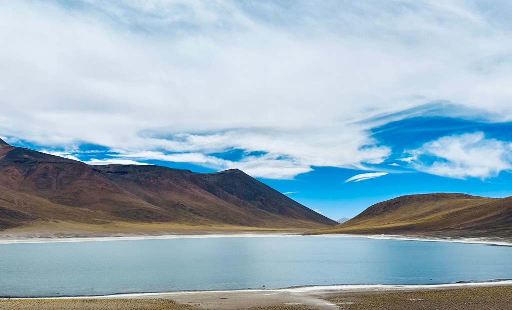
Located east-southeast of the Salar de Atacama, the Miscanti and Miñiques lakes lie at the base of the Cerro Miscanti volcano. These lakes are part of the Los Flamencos National Reserve and are rich in wildlife and geological features. Situated 90 kilometers from San Pedro and over 4,000 meters above sea level, they draw water from the ground, attracting various animals, including many flamingoes, which contrast beautifully with the snowy mountains reflected in the water. These two blue lakes, surrounded by the driest desert on earth, are 10 meters deep and remain untouched in a stunning natural setting.
Visit the highest geysers of the world– Tatio Geysers
The Geysers of San Pedro de Atacama, located in the Andes mountains at 4,200 meters and 89 kilometers from San Pedro, offer stunning views and impressive steam columns rising up to 8 meters, particularly around sunrise. Visitors are advised to wear warm clothing and bring swimwear, as thermal pools are available nearby. The best viewing time is between 6:00 and 7:00 AM, with steam temperatures reaching 85°C. The area features a variety of wildlife and plants, making it a remarkable attraction in the Atacama Desert.
We skipped the Tatio geysers because no one wanted to wake up at 4 AM to see them, and the kids said they had already seen Old Faithful in Yellowstone and geysers in Iceland. The best way to see the geysers would be to take a tour; that way, you can leave the early morning driving to locals. Entrance to El Tatio Geysers costs CLP$ 15,000 per person and is paid in cash at the entrance.
Final Thoughts
All in all, Atacama is a great place to visit, offering breathtaking landscapes and unique natural wonders. However, be prepared to drive 1-2 hours to explore the various attractions scattered throughout the region, as they are often quite remote. It’s important to plan your itinerary carefully, as some sites may require more time than others to fully appreciate their beauty. With very limited information available on various attractions, opting for a guided tour might be a better way to ensure you make the most of your visit and get maximum bang for your buck. A knowledgeable guide can provide insights into the area’s rich history and geology, making for a more enriching experience. Plus, they can help navigate the sometimes challenging terrain, allowing you to focus on enjoying the stunning scenery.
Costa Rica… a paradise of lush rainforests, golden beaches, and vibrant biodiversity, where nature lovers and thrill-seekers alike find their haven. Here, travelers can immerse themselves in the lively streets of San José, filled with rich history, bustling markets, and welcoming locals. Or, venture beyond the capital into the heart of the country’s breathtaking wilderness—where towering volcanoes, misty cloud forests, and exotic wildlife create a mesmerizing world waiting to be explored.
Costa Rica’s magic is undeniable—from the dazzling Pacific and Caribbean coastlines to the serene beauty of its national parks, home to sloths, toucans, and colorful frogs. Whether riding the waves in Tamarindo, ziplining through Monteverde’s treetops, or savoring the country’s renowned coffee, every moment here is an invitation to adventure and relaxation. Pura vida is more than a saying—it’s a way of life that welcomes visitors with open arms and unforgettable experiences.
Costa Rica is located in Central America, connecting North and South America. It borders Nicaragua to the north and Panama to the south.
The country is divided into seven provinces – San José (capital), Alajuela, Cartago, Heredia, Puntarenas, Guanacaste and Limón) and most popular destination include : San Jose, La Fortuna, Monteverde, Tamarindo, Nosara, Samara, Jaco, Manuel Antonio, Uvita, Drake Bay (See the map below)
Costa Rica doesn’t have an army as of Dec. 1, 1948 and very stable democratic country.
Official language- Spanish
Official currency- Colón (plural colones) (¢)
Where to fly?
There are 2 main airports and few small local airports –
SJO Aeropuerto Internacional Juan Santamaría – In San Jose (Capital)Juan Santamaría International Airport (Code: SJO) is the country’s main airport, located in Alajuela.
Daniel Oduber International Airport in Liberia (Code: LIR) good airport for travelling Guanacaste, Monteverde and La Fortuna
Places to go in Costa Rica
Costa Rica has so many places that you will be overwhelmed to choose one or two places to visit. I found Costa Rica might be a place we will have to visit more than once to cover the entire country. If you just want to see our itinerary, check here .
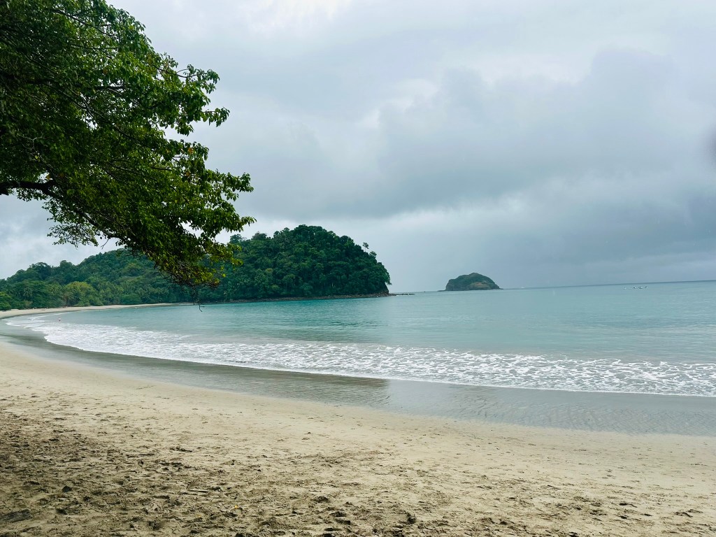
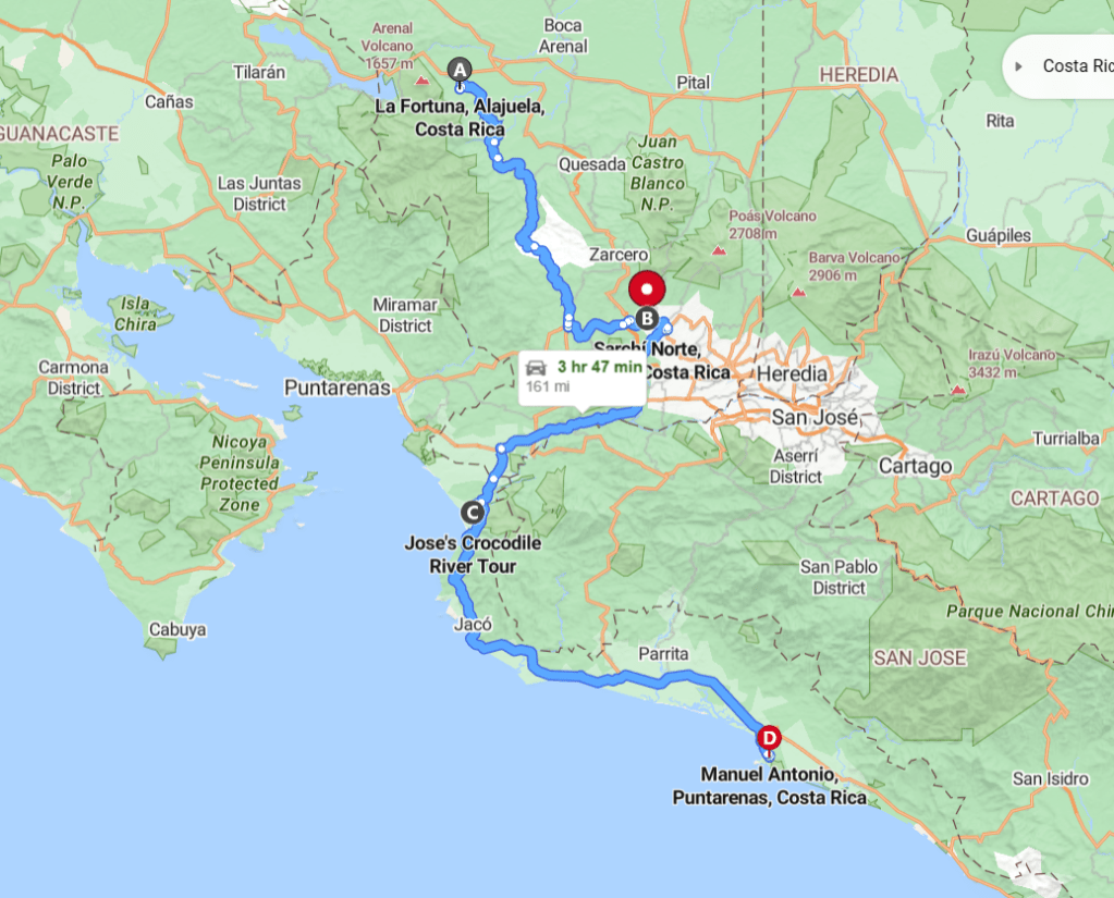
Even though a small country, it takes long time to travel from place to place due to mountainous, curvy, single lane roads. For instance, to travel from La Fortuna to Manuel Antonio, it took us almost 6 hours and it is 136 miles (218 km) apart and we were told that we were lucky that it took us only that much time (Hotel staff estimated anywhere between 6-9 hours). Keeping this in mind, we decided to choose 2 places to visit for our first trip- La Fortuna and Manuel Antonio (2 green flags on the map above)
Most popular locations include:
Central Costa Rica – Culture and nature
San Jose – Culture, Museum, Airport, Restaurants
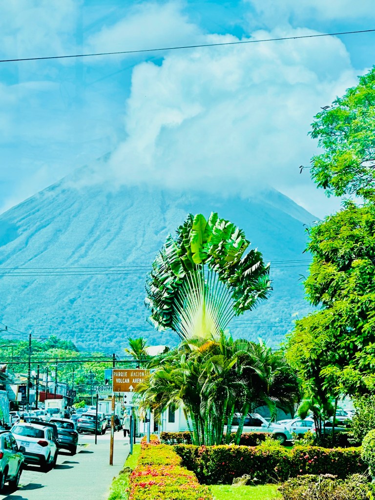
Poas volcano: most visited volcano in the Central Valley. Good stopping point between San Jose and La Fortuna
La Paz Waterfalls : La Paz Waterfall Garden is the another popular stop between San Jose and La Fortuna. This park has 5 waterfalls and an animal sanctuary.
Northern costa Rica – Outdoor adventure and Wild animals
La Fortuna / Monteverde – Best place for outdoor adventures
Distance from airport: Both San Jose airport and Liberia airport are about 2-3 hours.
Most people choose either La Fortuna or Monteverde for rainforest experience and some people do both places to experience rainforest and cloud forest (The cities are 80 miles apart). It takes about 5-6 hours to get to Monteverde from La Fortuna as you have either take a ferry to cross Lake Arenal or drive around Lake Arenal. This is the info from costa Rica Travel blog and if you want to include both La Fortuna and Monteverde in your travels, please check out this blog for details of travel between the two cities.
Rio Celeste – Another great place to visit near La Fortuna with a blue waterfall and lots of wild life. My review of this place is here
We dedicated day 5 for the long drive from La Fortuna to Manuel Antonio. There is not too much to do between these places other than stopping at Sarchi (https://www.atlasobscura.com/articles/colorful-oxcarts-costa-rica) to visit the last factory that makes Ox Cart. We stopped at the Río Tárcoles Crocodile Bridge which is near Jaco, and you can see lots of crocodiles in the river. There are few shops and restaurants here and it’s a good place to stretch your legs.
Guanacaste - Beaches, Surfing lessons,
Some popular spots in this area include Gulf of Papagayo, Tamarindo, Playa Conchal and Ricon De la Vieja National park- famous for natural hot springs and mud baths.
Nicoya Peninsula– Pristine beaches and yoga retreats
Santa Teresa– Beautiful beaches that are great for surfing. This town along with Malpais and Montezuma are in the blue zone where longevity of people is very high.
Playa Samara- Lovely beach town and famous for horse riding. Popular place for expats.
Nosara – Epicenter of Yoga retreats and epitome of Pura Vida lifestyle.
Osa Peninsula– Nature lovers and Photographers dream
Remote part of the Costa Rica on the pacific side and hence less touristy but home to Corcovado National Park which has 13 types of ecosystems and has amazing wildlife with over 40 species of frogs, 25 lizard’s species, crocodiles and 400 bird species. This is next my list to visit when we go back to Costa Rica
Drake Bay – Stunning destination for all water related actives including Snorkeling, Kayaking, scuba diving etc. Also great place for bird watching and hiking
Uvita– Famous for “The whale tail beach” as well as tropical rain forest. Good place to see humpback whales and other activities including waterfall visit, horseback riding etc.
CaribbeanCoast – Less touristy and chill vibe
Not as popular as the pacific coast , Carribean coast has its own vibe and blend of Latin and Carribean cultures. Some of the popular spots include :
Puerto Viejo – known for its stunning beaches, abundant wildlife and delicious food, this town gives the laid back feel that Caribbeans are known for. You can also visit Cahuita National Park to see monkeys, Sloths and birds.
Tortuguero National park– Located on the northeast side of the Caribbean coast, this national park is one of the best places in the world to see Giant Green Sea Turtles lay their eggs and to watch as the baby turtles hatch and make their way to the sea during the turtle season (June to October).
Some practical Information
Best season to visit is during dry season from December to April. We went at the end of December and still got rain almost every day for at least couple of hours.
Caribbean coast has very different season and less developed. Good time to see turtles hatching is between July to October
Nature and wildlife- Hiring guides help to see more animals but I also found that by paying attention to little noises (ruffling of leaves) or just looking up to the treetops helps a lot.
Tico time- Pack lot of patience. The Pura Vida life style is followed on the roads too. Driving from one location to another takes longer than you think due to one lane roads and getting behind slow moving trucks.
Popular locations such as La Fortuna, Manuel Antonio are very well connected but if you plan to go to remote locations such as Drake Bay, do some research.
Colones and dollars are accepted every where but it might be cheaper to use colones
Some essential things to pack- Dry bag or waterproof pouch, Light rain jacket, Water sandals or shoes, Bug spray, Binoculars, Sunscreen.
Like any other place, there are pick pocketers, and thieves that take your stuff if you leave it alone. Lock your vehicles and hide your valuables.