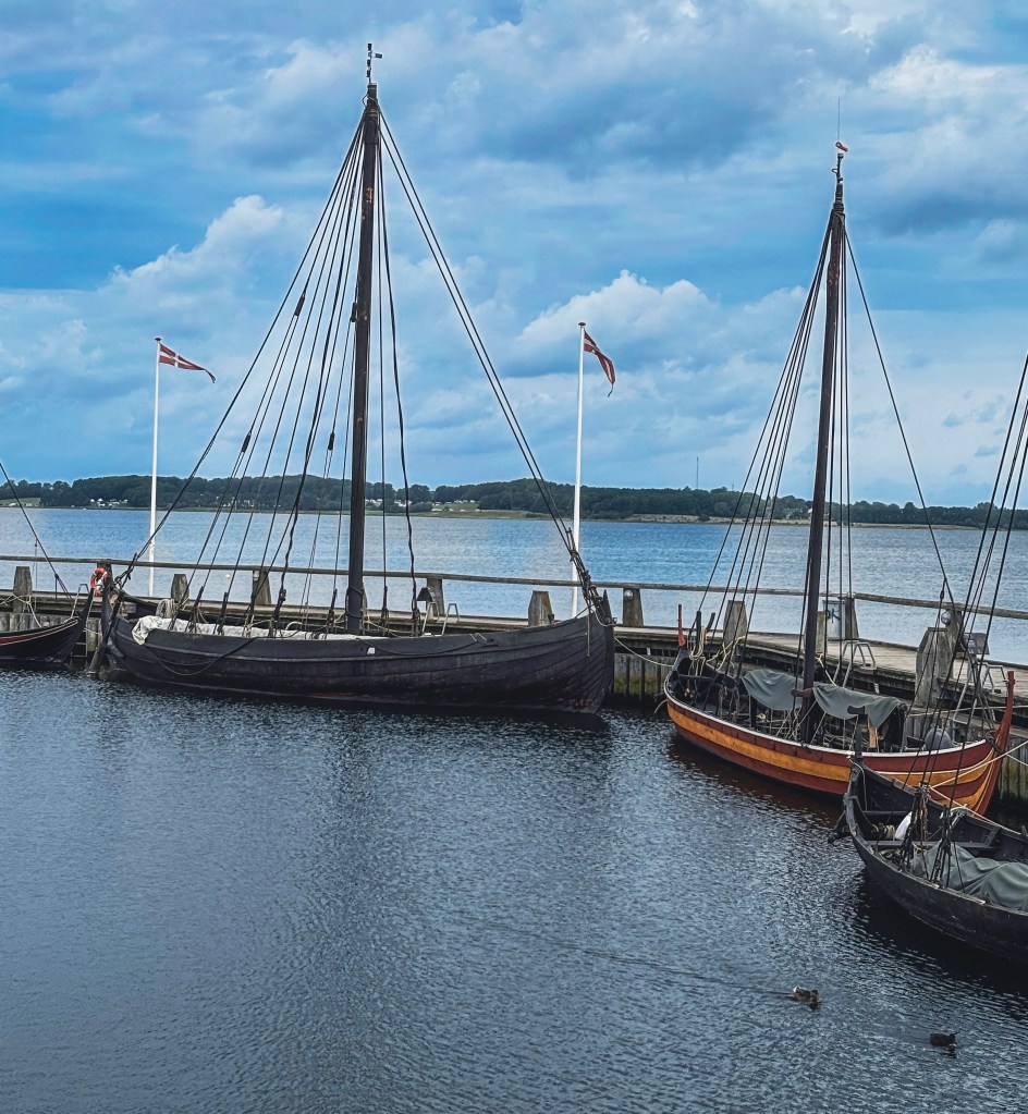
For anyone captivated by the age of the Vikings or the sheer ingenuity of ancient seafaring, the Viking Ship Museum in Roskilde, Denmark is a destination that feels like stepping into another world. Nestled along the Roskilde Fjord, this museum is more than a collection of artifacts—it’s a living, breathing tribute to the maritime spirit of the 11th century.
⚓ Things to Do at the Viking Ship Museum
The Viking Ship Museum isn’t just about looking—it’s about living history. Visitors can dive into a range of experiences that bring the Viking Age to life:
Seasonal Highlights: Summer brings outdoor workshops, sailing demonstrations, and lively festivals that transform the museum grounds into a Viking village.
Explore Interactive Exhibits: Step into the world of Viking navigation, craftsmanship, and daily life through hands-on displays.
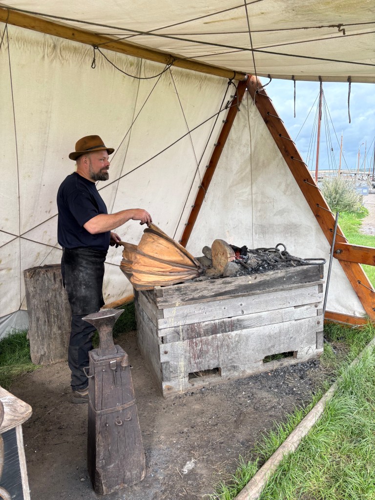
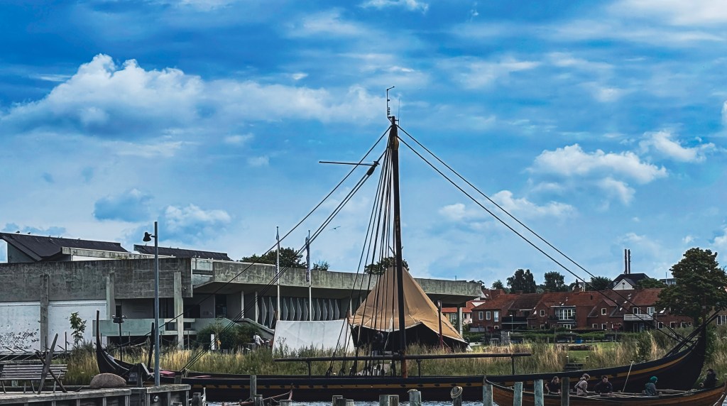
Watch Shipbuilding in Action: At the boatyard, skilled craftspeople reconstruct vessels using age-old techniques. The sound of axes and hammers against timber echoes across the fjord, just as it did centuries ago.
Sail Like a Viking: Join the “Learn to Sail a Viking Ship” course, where you’ll hoist sails, row in rhythm, and navigate the fjord without modern tools. It’s teamwork, history, and adventure rolled into one.
Family Fun: The Children’s Museum area offers interactive activities designed for younger explorers, making history accessible and exciting for all ages.
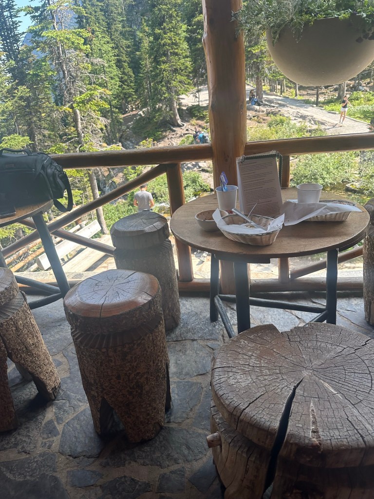
Taste Local Flavors: Relax at the onsite café and restaurant, where Danish specialties are served with sweeping views of the fjord.
🚢 The Five Giants of Skuldelev
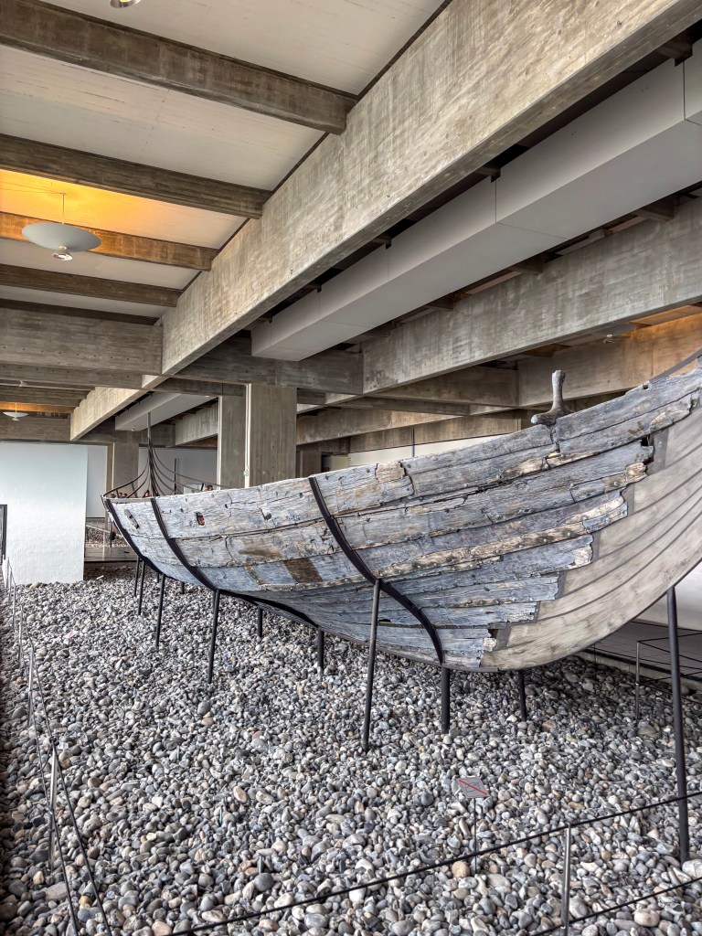
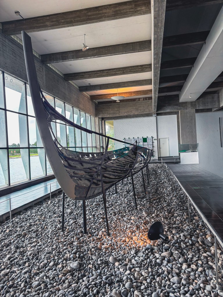
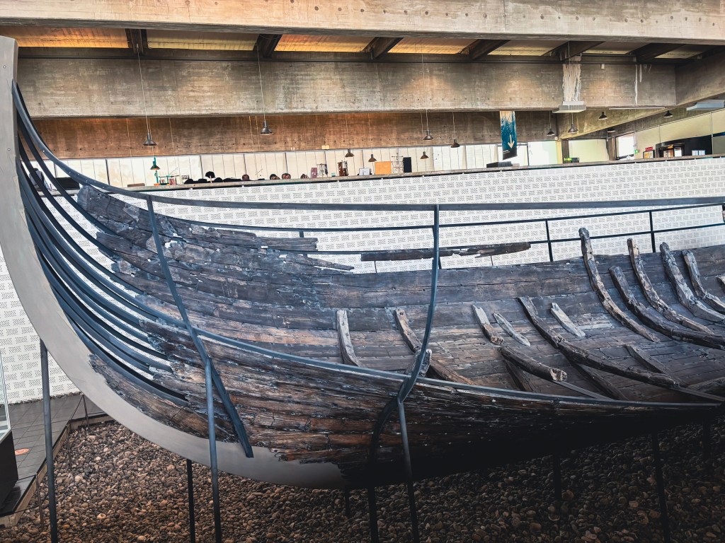
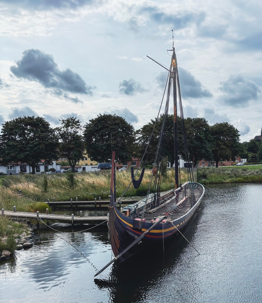
The museum’s crown jewels are the five Skuldelev ships, discovered in 1962 beneath the icy waters of the fjord. These vessels weren’t buried in honor—they were deliberately sunk around 1070 AD to form blockades in Roskilde Fjord, protecting the capital from seaborne attacks during the troubled end of the Viking era. Today, they stand as silent guardians of Viking ingenuity.
Origins: Built between 1024 and 1040, the ships’ age was determined by studying tree rings. They were crafted in Ireland, Norway, and Denmark, reflecting the vast reach of the Viking empire.
Types of Ships:
One massive warship capable of carrying 60 warriors on raids across England, Paris, Normandy, and beyond.
Two sturdy cargo ships that sustained Viking trade networks.
One versatile fishing/long-cargo vessel used in everyday life.
One additional warship, smaller but equally swift.
Rediscovery: Local fishermen had long known of the wrecks beneath the fjord. In 1962, archaeologists raised the five surviving ships from the seabed. Sadly, one more vessel was lost—during World War II, fishermen caught fragments in their nets and used the wood for fuel.
Living History
Today, three of the ships are displayed in the museum hall, where interactive exhibits reveal their construction secrets. The other two often take to the water, proving that Viking craftsmanship still holds seaworthy power. Visitors can also watch shipbuilders at the museum’s boatyard, where traditional techniques echo across the fjord.
🪵 More Than Just Old Wood
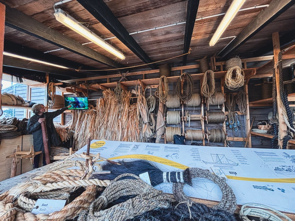
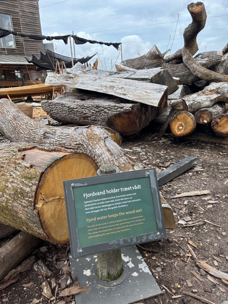
The museum isn’t just about gazing at relics—it’s about experiencing Viking life firsthand. Exhibits showcase tools, navigation methods, and daily routines, while the boatyard buzzes with activity. This place attracts some of the best master craftsmen from around the world, and you can watch them rebuild ships using traditional techniques, their rhythmic hammering echoing across the fjord. Some of the boats built by these craftsmen can be seen in museums around the world.
Visitors can watch the process up close, and for those who fall in love with the artistry, even purchase a handmade wooden boat—a piece of Viking heritage to take home.
Making Iron screws in the old-fashioned wayRope makingSeasoning the wood
🌊 A Unique Adventure: Learn to Sail a Viking Ship
Perhaps the most unforgettable experience is the “Learn to Sail a Viking Ship” course. This isn’t a modern sailing lesson—it’s a plunge into history. Participants work together to hoist the heavy square sail, navigate the fjord, and feel the raw challenge of controlling a vessel without modern technology.
It’s equal parts exhilarating and humbling, offering a taste of the teamwork and skill that defined Viking voyages. Whether you’re a seasoned sailor or a curious beginner, this adventure is a rare chance to live history.
👨👩👧 Family-Friendly & Traveler Tips
Children’s Museum Area: Interactive exhibits designed for younger explorers.
Onsite Café & Restaurant: Serving local Danish fare with fjord views.
Seasonal Activities: Summer often brings outdoor workshops, sailing demonstrations, and festivals.
Practical Info: The museum is a short walk from Roskilde Cathedral, making it easy to pair both sites in a day’s itinerary.
🌟 Why Roskilde’s Viking Ship Museum Belongs on Your Journey
The Viking Ship Museum isn’t just about ships—it’s about stories of resilience, exploration, and craftsmanship. Standing before the Skuldelev vessels, you don’t just see wood and iron—you glimpse the spirit of a people who dared to cross oceans in pursuit of trade, conquest, and discovery.
Whether you’re tracing history, seeking adventure, or simply dreaming of the open sea, Roskilde offers an unforgettable voyage back in time.
👉 Ready to plan your own adventure? Visit the official Viking Ship Museum Roskilde website for visitor information, tickets, and course bookings.
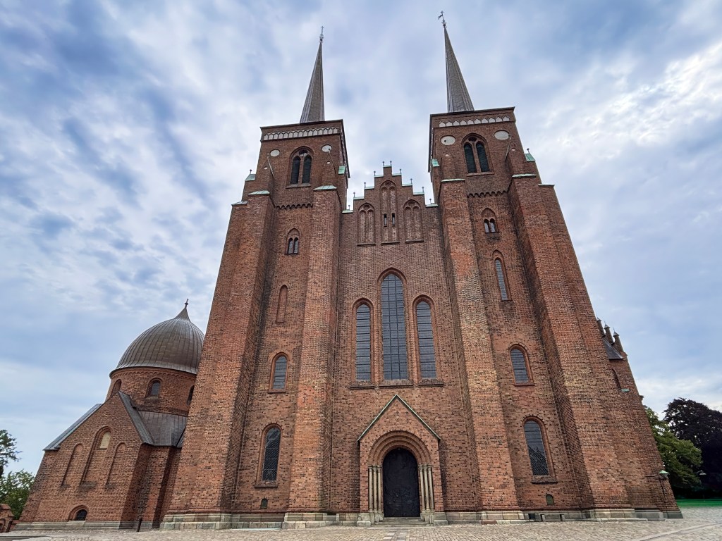
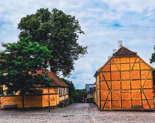
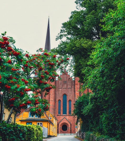
Step into Roskilde, Denmark, and you’re walking straight into the pages of history. Long before Bluetooth connected our phones, King Harald “Bluetooth” connected his kingdom to Christianity. Around the year 980, he built a wooden church in Roskilde. This church set the stage for centuries of royal tradition. By 1080, that humble wooden chapel had been replaced by a grand travertine structure. Eventually, the soaring brick cathedral that dominates Roskilde today rose from the same sacred ground.
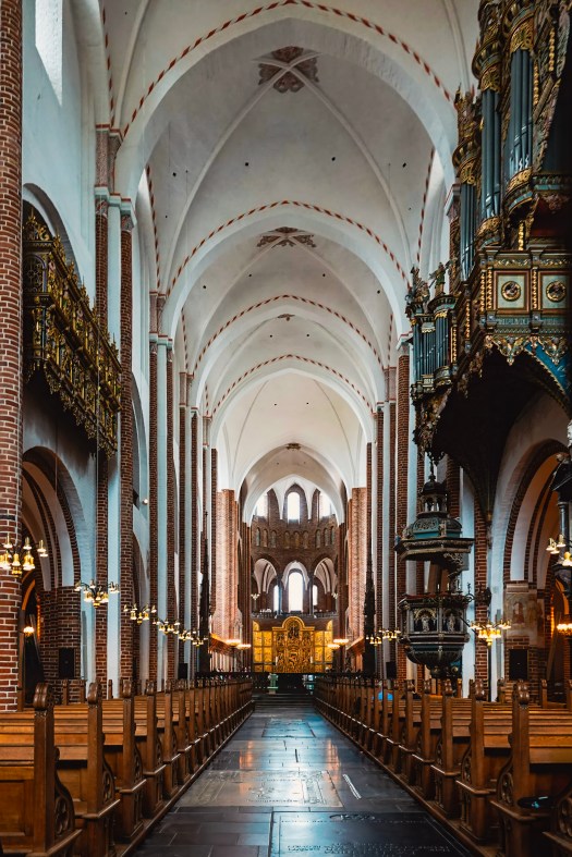
This isn’t just another church. It’s the beating heart of Denmark’s royal past. It is a UNESCO World Heritage Site. It is also the final resting place of kings and queens who shaped the nation. As you wander through its towering Gothic arches and past centuries-old tombs, you’re not just sightseeing. You’re tracing the footsteps of Vikings, monarchs, and visionaries who left their mark on Europe.
📍 Location: Roskilde, just 30 minutes by train from Copenhagen.
🕰️ Opening Hours: Typically open daily, but check ahead for seasonal changes. You can check the opening hours here.
🎟️ Tickets: Small entrance fee, with discounts for students and families.
🌸 Best Time to Visit: Spring and summer for lively festivals, autumn for fewer crowds.
🎶 Nearby Attractions: Pair your visit with the Viking Ship Museum or, if you’re lucky, the world-famous Roskilde Festival.
The layout of the cathedral
A Walk Through Time
The story begins with Harald Bluetooth, the Viking king who unified Denmark and Norway and introduced Christianity to his people. His wooden church in Roskilde was modest, but symbolic—it marked the dawn of a new era.
By 1030, Estrid, sister of King Canute the Great, replaced Harald’s wooden chapel with a travertine stone church. Just fifty years later, Bishop Svend Normand oversaw the construction of an even larger travertine church in 1080. These stone structures paved the way for the magnificent brick cathedral that began rising in the 1170s under Bishop Absalon.
Each phase of construction reflects Denmark’s transformation—from Viking paganism to Christianity, and from wood to stone to brick.
Architectural Marvel
Roskilde Cathedral isn’t just old; it’s groundbreaking. Built in the 12th century, it was the first major brick church in Scandinavia, setting the standard for northern European architecture. Its soaring Gothic arches, Romanesque foundations, and later Renaissance and Baroque additions make it a living museum of styles.
Recognized as a UNESCO World Heritage Site, the cathedral embodies more than 850 years of European architectural evolution. Walking through its chapels feels like time travel, each corner whispering stories from a different century.
🚪 The King’s Door: A Modern Symbol in an Ancient Cathedral
Not all of Roskilde Cathedral’s treasures are centuries old. In 2010, Danish artist Peter Brandes designed and installed The King’s Door, a striking bronze portal that replaced an older entrance. Its design tells the biblical story of the Journey to Emmaus: after Jesus’ death, two disciples meet a stranger and share a meal with him. When he breaks the bread, they suddenly recognize the resurrected Christ.
The symbolism is powerful—recognition, revelation, and transformation—echoing the cathedral’s role as a place where history and faith meet. According to tradition, only the Danish royal family may enter through this door, while others may leave through it. It’s a subtle but fascinating reminder of the cathedral’s continuing role in Denmark’s monarchy and spiritual life.
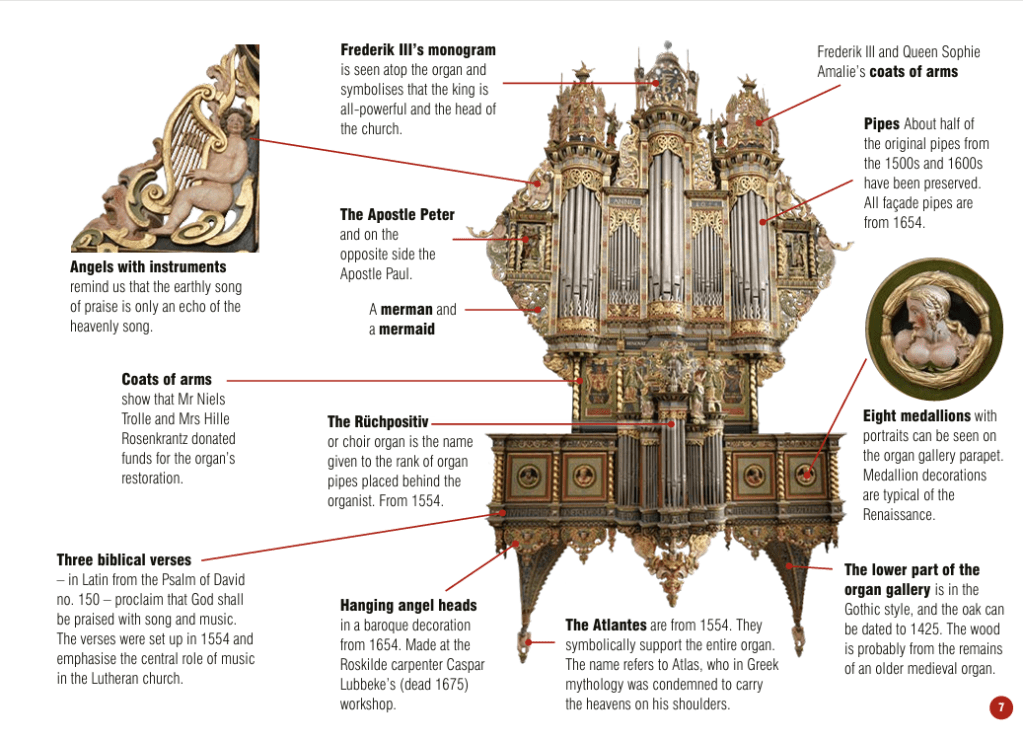
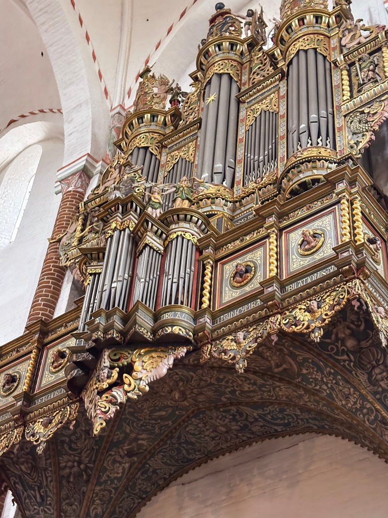
🎶 The Raphaëlis Organ: A Soundtrack to Centuries
As you wander through Roskilde Cathedral, don’t miss the majestic Raphaëlis organ. It is perched high above the nave. The organ sits like a musical time capsule. Known for its vintage tone and considered one of the world’s finest, this baroque masterpiece has echoed through the cathedral for centuries. Originally rebuilt in 1554 by Dutch organ builder Herman Raphaëlis, it underwent a dramatic transformation in 1654 to reflect the ornate Baroque style of the time. Today, the organ blends elements from the Middle Ages, Renaissance, and Baroque, making it a living archive of European music history.
Once reserved for Latin chants sung by priests, the organ’s role expanded after the Reformation in 1536, when congregational singing in Danish became central to worship. The cathedral now hosts regular services and concerts, and even runs a choir school for children alongside several adult choirs—ensuring that music remains at the heart of this sacred space.
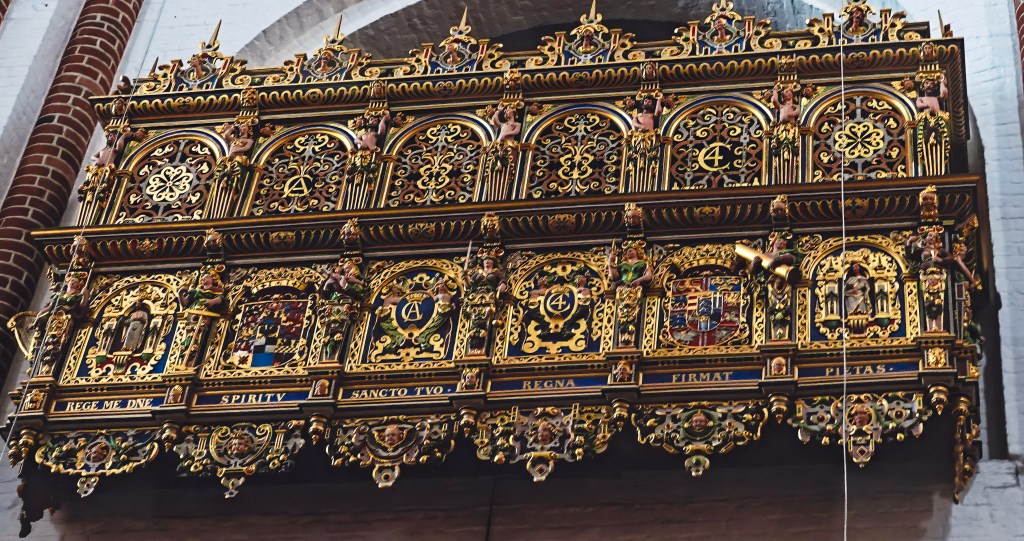
👑 The Royal Box: A Glimpse into Regal Worship
Tucked into the grandeur of Roskilde Cathedral is a quiet relic of royal tradition—the Royal Box, donated by King Christian IV. This elegant feature once offered private viewing rooms for the monarch and queen, allowing them to attend services with dignity and discretion. One room was reserved for the king, the other for the queen, reflecting the ceremonial formality of royal worship in earlier centuries. Though no longer in use, the Royal Box remains a fascinating architectural detail. Today, royal visitors are seated in the chancel, closer to the altar, blending tradition with modern protocol while preserving the cathedral’s deep connection to Denmark’s monarchy.
✨ The Sacred Stage: Where Monarchs Met the Divine
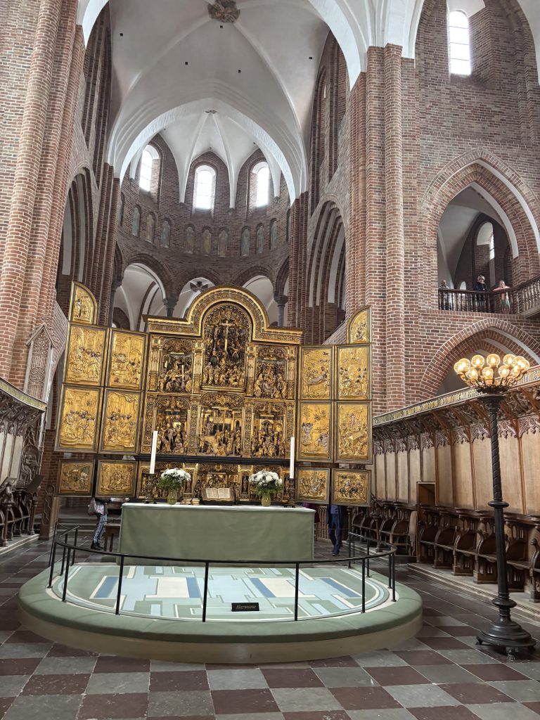
At the heart of Roskilde Cathedral stands the main altar, a place of profound spiritual and royal significance. Initially reserved for Catholic mass, it was later transformed by the Reformation. Over centuries, the altar has witnessed Danish monarchs kneeling in prayer. They have been crowned in ceremony and honored in death.
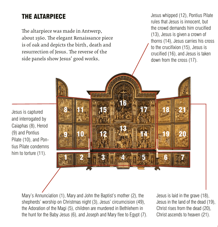
The altarpiece, crafted in Antwerp around 1560, is a jewel of Renaissance artistry. Carved from oak, it unfolds like a visual sermon, depicting the birth, death, and resurrection of Jesus in intricate detail. The reverse of its side panels reveals scenes of Christ’s good works, offering a dual narrative of devotion and compassion. 2 things to notice on this altar piece.
Scenes of Christ’s Life The central panels vividly depict the birth, death, and resurrection of Jesus, offering a complete narrative of salvation in one sweeping work of art.
Reversible Side Panels Turned outward, the side panels reveal Christ’s good works—moments of compassion and teaching that balance the drama of the central story with everyday acts of faith.
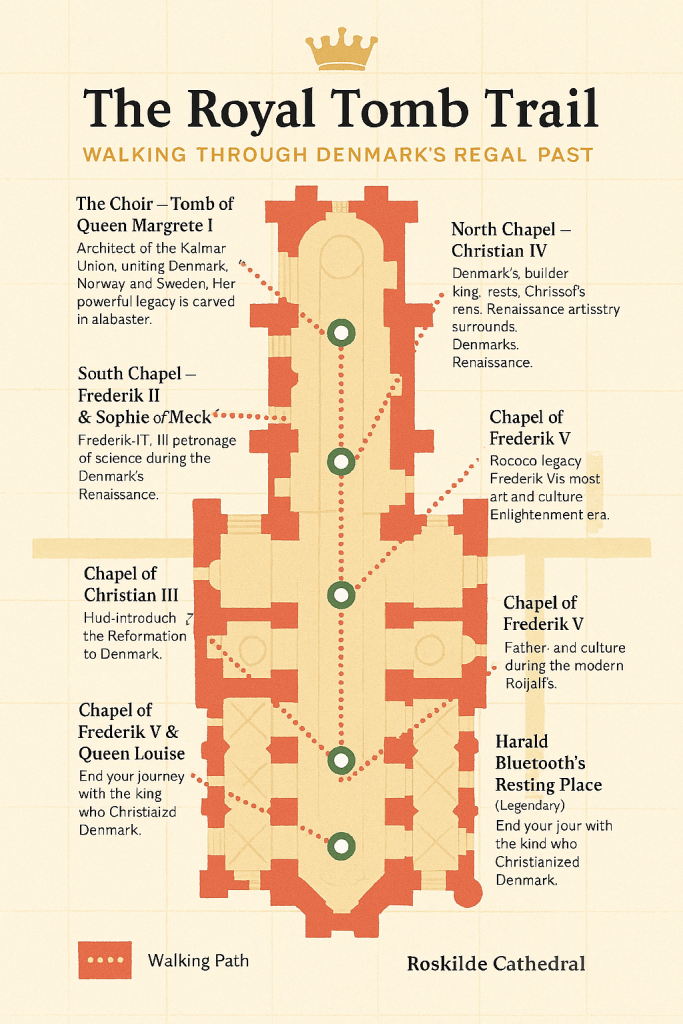
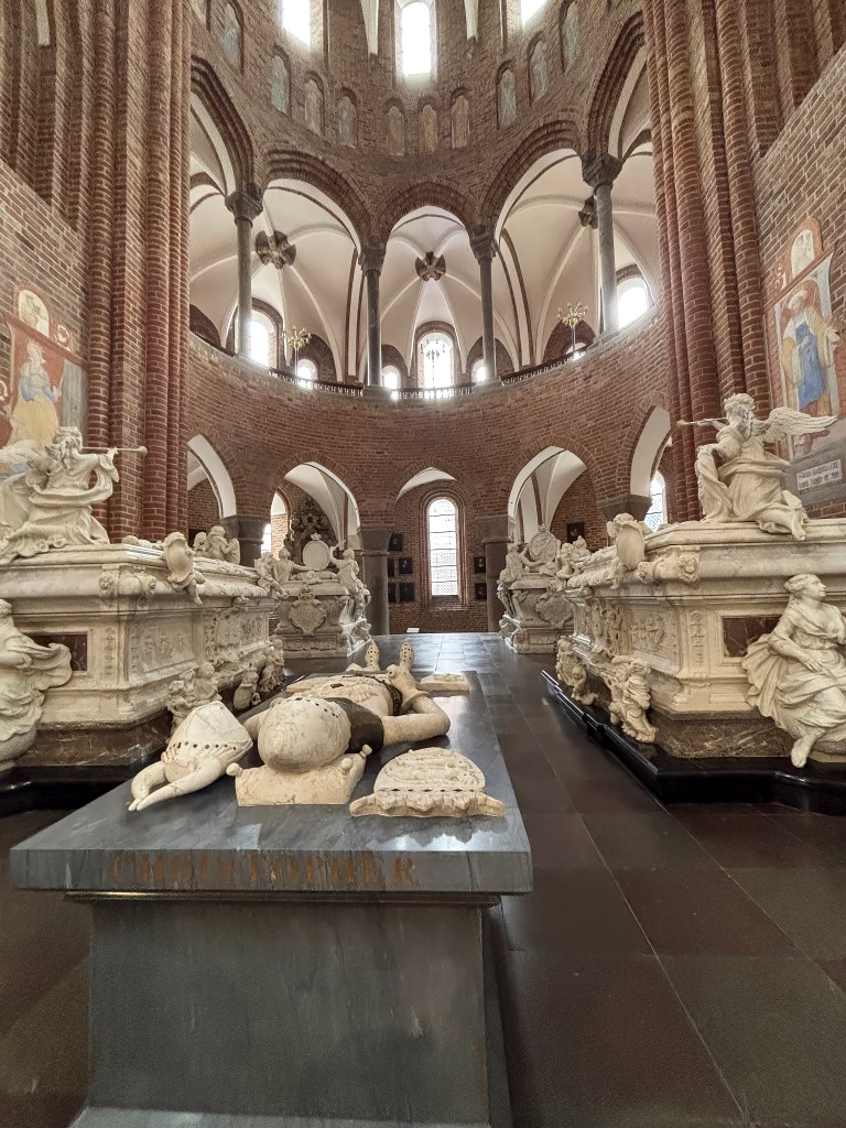
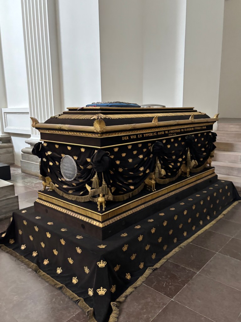
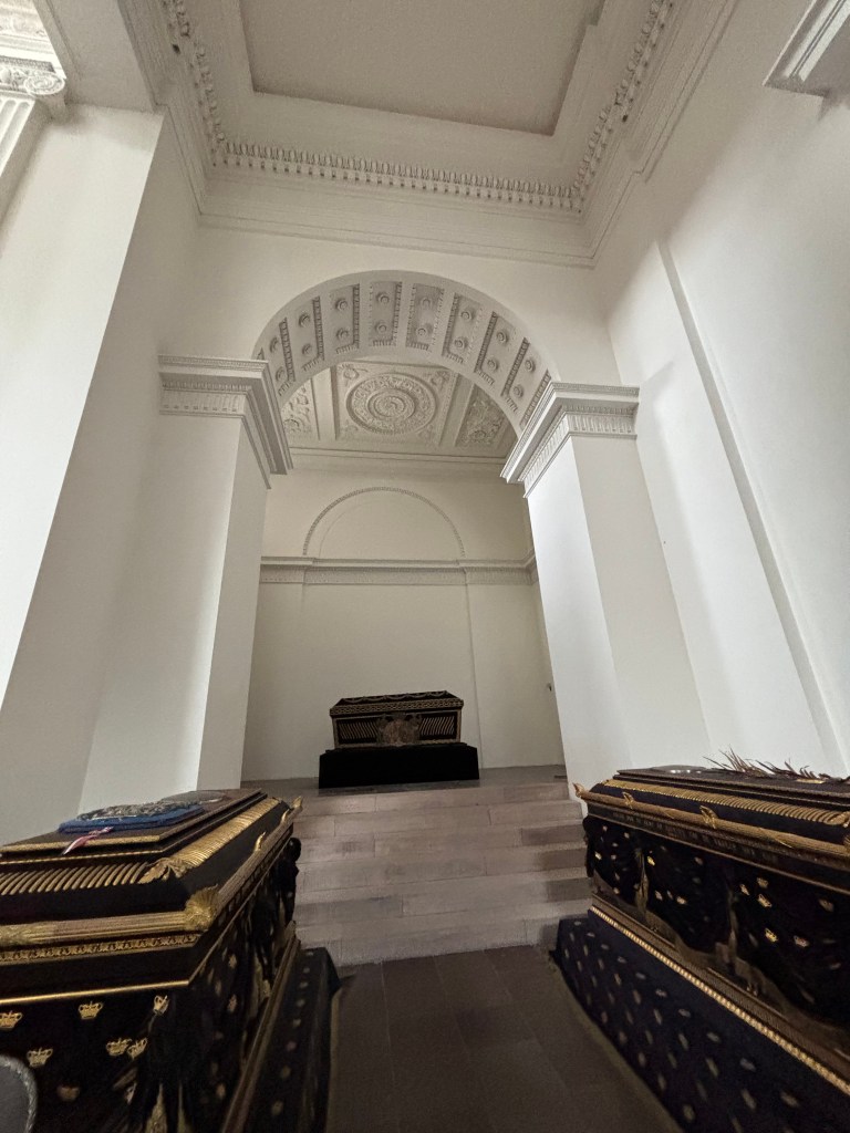
👑 The Royal Tomb Trail: Walking Through Denmark’s Regal Past
🚪 Starting Point: The Choir – Margrete I
Start your trail in the choir, the holiest part of the cathedral. Here lies Queen Margrete I, the founder of the Kalmar Union, whose sarcophagus rests directly behind the altar. Her unusual placement reflects her extraordinary power and the reverence she commanded. Pause here to learn about her secret reburial in 1413.
👑 The Absolute Monarch: Christian V in the Canon’s Chancel
Christian V’s burial site is located right behind Margrete I tomb. It is in the Canon’s Chancel and places him at the heart of the cathedral’s clerical space. This symbolizes the close ties between royal power and religious authority. His reign marked the consolidation of the absolute monarchy. This was codified in Denmark’s laws. His tomb reflects this era of centralised royal control.
✨ Three Things to Notice at Christian V’s Tomb
Dynastic Grouping Christian V rests near Frederik IV and their queens, Charlotte Amalie and Louise. This grouping emphasizes dynastic continuity, showing how Roskilde became a family mausoleum for successive monarchs.
Baroque Influence The tomb’s design reflects the Baroque style of the late 17th century. It is characterized by grandeur and ornamentation. These elements mirror the cultural tastes of his reign.
Placement in the Canon’s Chancel Unlike Margrete I behind the altar or Christian IV in his starry chapel, Christian V’s tomb is placed within the clergy’s space. It is integrated there. This placement highlights the intertwining of royal authority and ecclesiastical tradition. It serves as a reminder of how monarchs shaped worship. Monarchs also influenced politics.
🌌 The Builder King’s Chapel – Christian IV
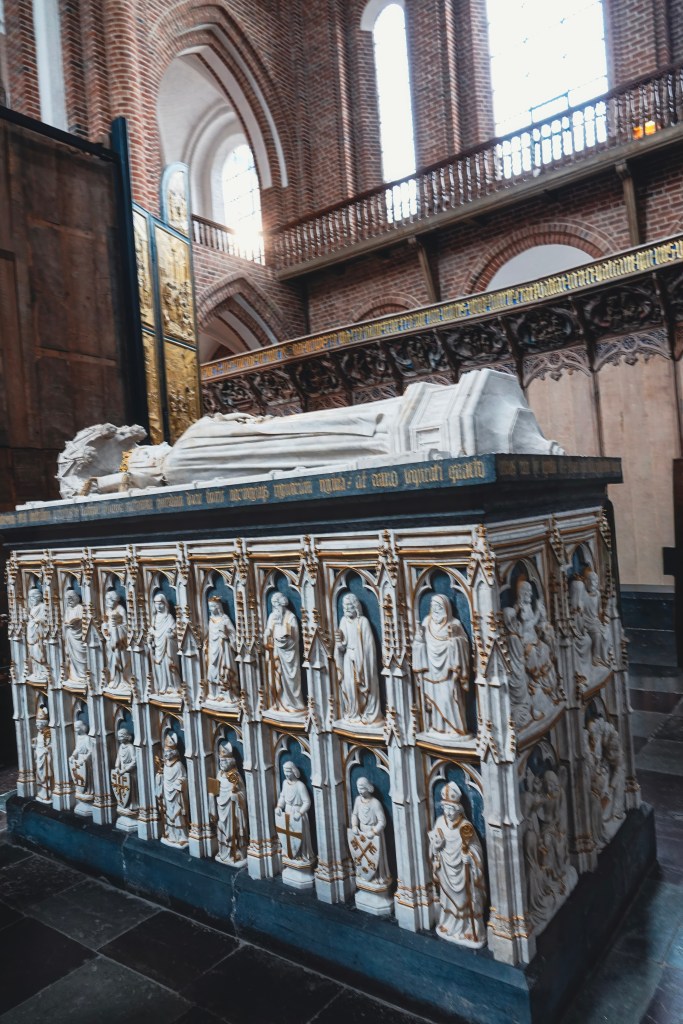
Step into the Chapel of Christian IV, Denmark’s longest‑reigning monarch. Known as the “Builder King,” he left behind castles, towers, and fortifications across the country. His tomb is set beneath a vaulted ceiling painted deep blue with golden stars, creating a celestial canopy. Notice the ornate sarcophagus and knightly statues that frame his resting place, symbols of both his ambition and his martial strength.
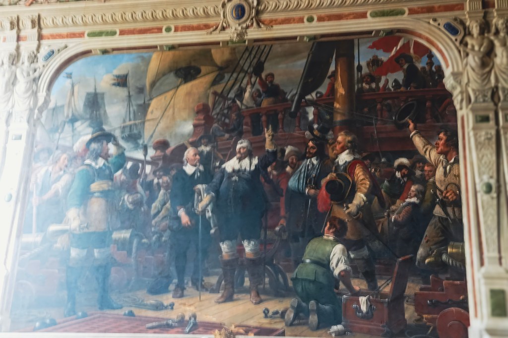
***Inside King Christian IV’s chapel, there is a striking painting that commemorates his bravery at the Battle of Colberger Heide (1644).
The artwork depicts Christian IV wounded in the eye by shrapnel during the naval battle against Sweden. Despite his injury, he famously refused to leave the deck of his flagship Trefoldigheden, continuing to command his men. This moment became a national symbol of courage, later immortalized in Wilhelm Marstrand’s 19th‑century painting, which hangs in the chapel as part of the king’s memorial.
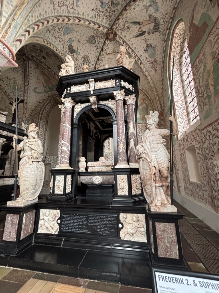
🌹 South Chapel – Frederik II & Sophie of Mecklenburg
Cross to the South Chapel, where Frederik II and his queen, Sophie, rest side by side. Frederik II was a patron of science and supported Tycho Brahe, the famed astronomer.
Their tombs are adorned with Renaissance flourishes—roses, stars, and celestial symbols—hinting at the intellectual flowering of their era. Sophie’s tomb is especially elegant, reflecting her influence as a learned and politically savvy queen.
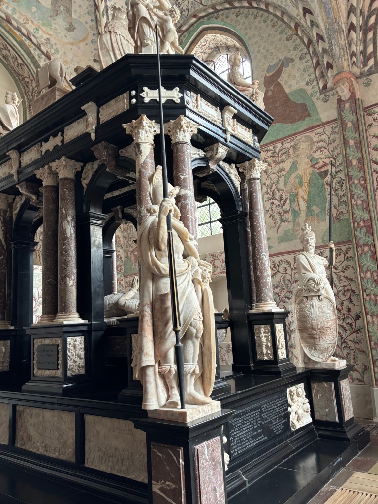
🏰 Chapel of the Three Kings – A Regal Triad
As you step into the Chapel of the Three Kings, you are immediately struck by the grandeur of two monumental tombs that dominate the space. These are the sepulchral monuments of Christian III and his son Frederik II, standing side by side in solemn symmetry.
Christian III’s Monument Crafted in Antwerp by the innovative sculptor and architect Cornelis Floris (ca. 1514–1575), Christian III’s tomb reflects Renaissance artistry with its balance of grandeur and restraint. It embodies the king’s legacy as the Reformation monarch, who introduced Lutheranism to Denmark.
Frederik II’s Monument While his father’s tomb was being built, Frederik II commissioned his own—deliberately modeled on Christian III’s design. Yet, in true Renaissance fashion, he made his monument slightly larger. It was more detailed. This was a subtle assertion of his own reign’s prestige. His monument carries richer ornamentation, echoing his patronage of science and culture, including his support of astronomer Tycho Brahe.
Beneath these monuments lie the crypts where both kings and their queens rest. Their presence marks a turning point: from Christian III onwards, all Danish monarchs have been buried in Roskilde Cathedral, cementing its role as Denmark’s royal mausoleum.
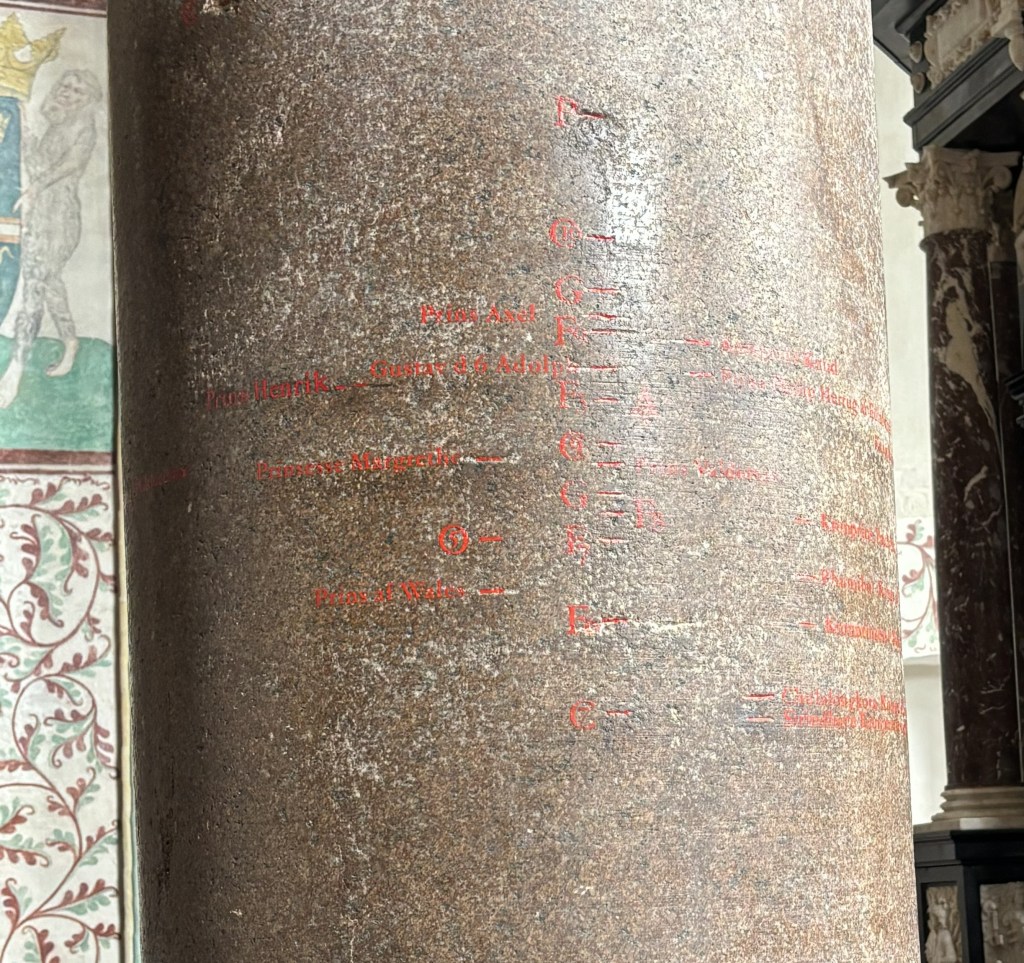
📏 The King’s Pillar – Measuring Majesty
Before leaving the Chapel of the Three Kings, pause beside the large granite column known as the King’s Pillar. Unlike the solemn tombs nearby, this pillar offers a playful yet poignant tradition: measuring the heights of visiting royals.
Etched in red inscriptions, the column records centuries of royal stature—literally. Among the most notable:
Tsar Peter the Great of Russia: Towering at 208.4 cm, he holds the record as the tallest royal measured here.
King Chulalongkorn of Siam: The shortest on record, his height adds a delicate contrast to the pillar’s legacy.
This tradition turns the chapel into a living ledger of monarchy—where stone remembers not just reigns and rituals, but the very presence of kings and emperors. It’s a charming reminder that even in death, royals leave behind more than monuments—they leave behind measurements.
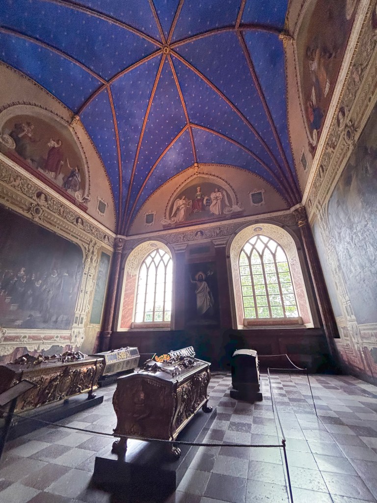
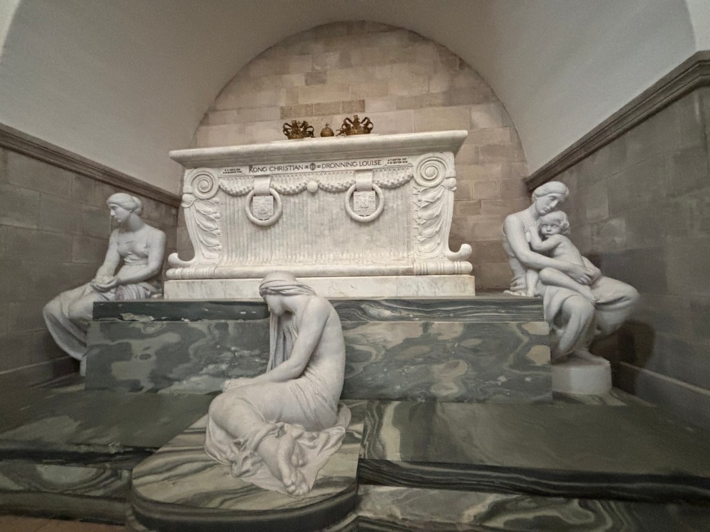
🕊️ Christian IX’s Chapel – The Grandparents of Europe
At the far end of Roskilde Cathedral lies the Christian IX Chapel, also known as the Glücksburger Chapel. Built between 1919 and 1924 in the Byzantine Revival style, this extension feels markedly different from the medieval and Renaissance chapels you’ve already explored. Its domed arches and mosaic-like ornamentation create a serene, almost modern atmosphere.
✨ The Double Sarcophagus
The northern arm of the chapel is dominated by a large white marble double sarcophagus, where King Christian IX (d. 1906) and Queen Louise of Hesse-Kassel (d. 1898) rest together. Their tomb is a symbol of enduring partnership, reflecting their role as the dynastic heart of modern Europe.
🎭 Sculptures of Emotion
Surrounding the sarcophagus are three Carrara marble statues by Edvard Eriksen, the sculptor behind Copenhagen’s iconic Little Mermaid. Each figure embodies a timeless human response to loss:
Grief – bowed in sorrow
Memory – contemplative, holding the past
Love – eternal devotion
Together, they transform the chapel into a space of reflection, where art and mourning intertwine.
The Little Mermaid’s sisters is another name for the female figures on Christian IX and Queen Louise’s sarcophagus. They were made by the sculptor Edvard Eriksen (1876-1959) whose wife posed for them and his most well known work: The Little Mermaid. They symbolise Remembrance, Grief and Love.
👑 Other Royal Burials
The chapel also houses:
King Frederik VIII and Queen Louise of Sweden-Norway
King Christian X and Queen Alexandrine
This makes the chapel a dynastic hub, connecting three generations of Danish monarchs.
🌍 The Grandparents of Europe
Christian IX and Queen Louise earned the nickname “Grandparents of Europe” because their children married into nearly every major royal family of the continent. Their descendants include monarchs of Britain, Russia, Greece, and beyond—making this chapel not just a Danish resting place, but a cornerstone of European royal history.
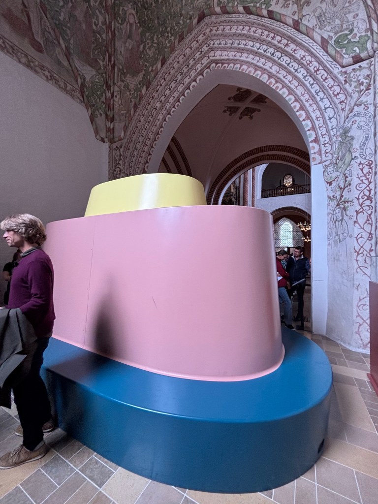
💎 St. Brigitte’s Chapel – A Monument to Modern Monarchy
Your trail through Denmark’s regal past ends not in stone, but in glass, bronze, and light. In St. Brigitte’s Chapel, the newest addition to Roskilde Cathedral’s royal mausoleum, stands the sarcophagus of Queen Margrethe II and Prince Henrik—a monument that reimagines royal memory for the 21st century.
🛠️ Designed by Bjørn Nørgaard
The monument was designed to be covered until after the Queen’s passing. The covering is a bench, also designed by Nørgaard, in three colors representing the Queen and her two sisters
🗝️ Hidden Gems Trail 🐾
Roskilde Cathedral isn’t just about towering Gothic arches and royal tombs—it’s also full of delightful surprises tucked into corners and galleries. For curious visitors, here’s a trail of hidden gems to seek out:
⏰ The Medieval Clock (c.1500): Watch as Kirsten Kimer strikes the quarter-hour bell, then stay for the drama of St George slaying the dragon on the hour, complete with a death wail before Per Døver strikes the big bell.
🚪 The King’s Door (2010): Designed by Peter Brandes, this bronze portal depicts the “Journey to Emmaus.” Tradition allows only the royal family to enter through it, while others may exit.
👑 The Royal Box: Donated by King Christian IV, it once held separate rooms for the king and queen during services. Though no longer in use, it’s a fascinating glimpse into royal ceremony.
🐾 The Dog’s Footprint: In the Middle Ages, a curious dog stepped into soft clay before a brick was fired. Its paw print remains immortalized in a windowsill in the gallery—a playful reminder that history isn’t only made by kings.
😇👿 Moses with Halo vs Horns: In the pew area, look closely at carvings of Moses. Some show him with a halo, others with horns—a quirky result of a medieval translation mix-up where “radiant” was misread as “horned.”
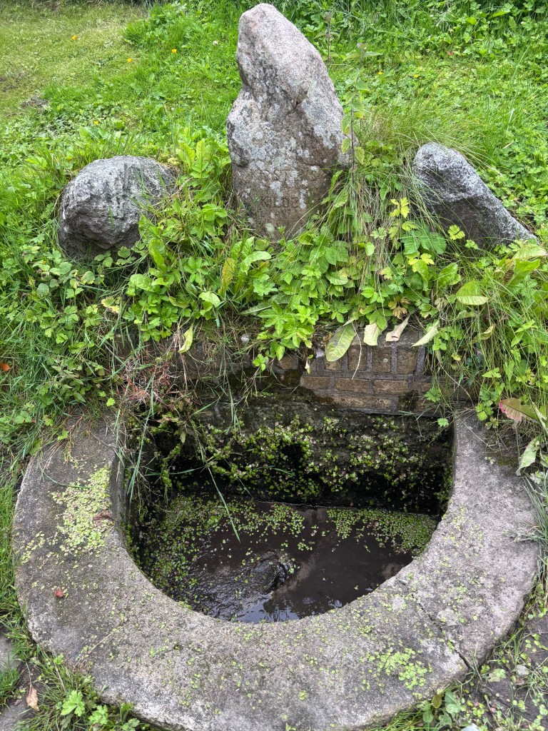
Rektorkilden – The Headmaster’s Spring
Just beyond the cathedral’s formal chapels lies a quiet, moss-lined spring with a story as dramatic as any royal tomb. Rektorkilden, or The Headmaster’s Spring, flows through the garden of the former residence of Roskilde Grammar School’s headmaster. Its current form dates to around 1880, though the buildings nearby trace back to 1821 and earlier.
Follow this trail, and you’ll uncover the cathedral’s personality beyond its grandeur—a mix of legend, artistry, and even a touch of canine mischief.
Paw print on the windowMosses with hornHeadmaster’s spring
🌍 Final Reflection
Roskilde Cathedral is more than a burial church—it is Denmark’s memory palace, where stone, glass, and legend converge. Each chapel tells a story of power, faith, and artistry, while hidden corners whisper tales of everyday life and folklore.
To walk the Royal Tomb Trail is to trace the arc of monarchy, from Viking kings to modern queens. To wander the Hidden Gems Trail is to glimpse the humanity behind the grandeur—dogs, mistranslations, and mythical monsters. Together, they remind us that history is not only about rulers and monuments, but also about the quirks, myths, and imperfections that make a culture alive.
Visiting Roskilde is not just sightseeing—it’s time travel, a journey through centuries where every stone and story invites reflection on how the past continues to shape the present.
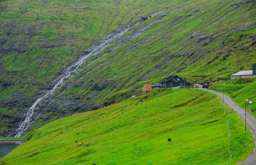
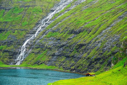
The Faroe Islands are a self-governing archipelago in the North Atlantic, known for their rugged terrain, rich Viking heritage, and vibrant fishing economy. Located between Iceland, Norway, and Scotland, the Faroe Islands consist of 18 volcanic islands. The phrase “Land of Maybe” was popularized during World War II, when British troops stationed there experienced the islands’ ever-shifting weather, which often disrupted schedules and travel plans. The name reflects the frequent fog, rain (it rains 300 days a year), strong winds, and sudden weather changes that characterize this rugged and isolated archipelago.
You can reach the Faroe Islands either by flying into Vágar Airport (FAE) with Atlantic Airways or SAS from major European cities, or by taking the Smyril Line ferry from Denmark or Iceland
✈️ Flying to the Faroe Islands
Main Airport: Vágar Airport (FAE), located on Vágar Island.
Airlines:
Atlantic Airways (the Faroese national airline) operates year-round flights to destinations such as Copenhagen, Edinburgh, Paris, Reykjavík, Oslo, and Barcelona.
SAS also connects Copenhagen to the Faroes.
Icelandic Air – Connects from Reykjavik
Flight Times:
About 2 hours from Copenhagen.
Just over 1 hour from Edinburgh or Reykjavík.
From North America: There are no direct flights. Travelers typically connect via Copenhagen, Reykjavík, or Edinburgh
🚢 Ferry to the Faroe Islands
Operator: Smyril Line.
Route: From Hirtshals, Denmark to Tórshavn, Faroe Islands, with stops in Iceland.
Duration: Around 36 hours from Denmark.
Advantages: You can bring your own car, making it easier to explore the islands independently
🌍 Travel Tips
Best Entry Point from the US: Fly to Copenhagen or Reykjavík first, then connect to Vágar Airport.
Seasonal Routes: Some destinations are only available in summer, so check schedules in advance. There are seasonal flights from Barcelona, Gran Canaria, and Mallorca, offering an even wider array of travel options
Weather Considerations: The Faroes are known for rapidly changing weather—plan flexible itineraries.
*** Pro-tip: Atlantic Airlines is the Faroese National airline and is better equipped to land during challenging weather conditions. The day I took Atlantic airline flight from Copenhagen to Vágar, Icelandic Air had cancelled the flight for weather-related reasons, and we had no issues landing. If you can, book through Atlantic Airline directly.
📍Where to Stay in The Faroe Islands Island
Accommodation in the Faroe Islands ranges from luxury hotels in Tórshavn to budget hostels, camping sites, guesthouses, and Airbnb-style rentals across the islands, giving travelers options for comfort, affordability, or immersion in nature. I decided to stay in Tórshavn for its central location and guided tour pickups. Next time, when I visit the Faroe Islands, I will probably choose one of the off-the-beaten-path Airbnbs, such as the View Hotel. You can check Booklocal.fo and vert.fo for a curated collection of Airbnb-style houses and flats available across most islands.
🏨 Hotels (4-star & boutique):
Found mainly in Tórshavn, offering spa treatments, fine dining, and modern amenities.
Here is a list of hotels in the capital city. I stayed at Hotel Hafnia and had a great stay
Hilton Garden Inn Faroe Islands – A modern hotel with water views, dining, and a hot tub. Great for travelers who want comfort and international standards.
Havgrím Seaside Hotel 1948 – A charming historic guesthouse overlooking Nólsoy Fjord, with nautical-inspired décor and serene coastal views.
Hotel Føroyar – Stylish lodging with a renowned restaurant and bar, plus free breakfast. Known for its hillside location and panoramic views of Tórshavn.
Hotel Brandan – Upscale and polished, featuring saunas, wine tastings, and a restaurant. Ideal for those seeking a boutique experience.
Hotel Hafnia – Centrally located in Tórshavn, offering modern rooms and a complimentary breakfast buffet.
visitHOMES (Leirvík) – Highly rated bed & breakfast with a homely atmosphere, perfect for travelers wanting a local touch.
Giljanes Hostel & Campsite (Sandavágur) – Budget-friendly option with shared kitchen facilities, popular among backpackers and hikers.
Hotel Tórshavn – Informal property with harbor views, a restaurant, and free breakfast. Conveniently located in the capital
Guesthouses & B&Bs:
Spread across smaller villages, ideal for travelers seeking a homely, local experience.
Platforms like Booklocal.fo and vert.fo curate unique stays in private homes
Check out visit Faroe islands webpage for some unique guesthouse and Airbnb options
Hostels:
Budget-friendly, often with shared kitchens and communal spaces.
Campsites are available across the islands, offering direct immersion in the Faroese landscapes.
RV camping is also possible, though facilities are limited.
⚠️ Travel Tips
Book Early: Accommodation is limited and demand is rising, especially in summer.
Expect Small Scale: The Faroes have only a handful of hotels; many stays are intimate and family-run.
Match Your Style:
Luxury → Tórshavn hotels.
Budget → Hostels or camping.
Authentic → Guesthouses or village B&Bs.
How many days to spend in the Faroe Islands
Most travelers spend 5–7 days in the Faroe Islands to see the highlights, but you can enjoy a shorter 3-day trip or extend to 9–10 days for a deeper, slower exploration.
Suggested Durations
3 Days:
Ideal for a quick getaway.
Focus on Tórshavn, Vágar (including the famous Múlafossur waterfall), and one or two nearby villages.
Great if you’re combining the Faroes with Iceland or Denmark.
5–7 Days (Most Popular):
Balanced pace to explore multiple islands.
Highlights include Streymoy, Eysturoy, Vágar, and Norðoyggjar.
Enough time for iconic hikes (like Sørvágsvatn lake and Slættaratindur peak) and cultural experiences in Tórshavn.
9–10 Days:
Perfect for slow travelers or photographers.
Allows visits to more remote islands like Suðuroy and Sandoy.
Flexibility to account for unpredictable weather, which often reshuffles plans. My day 1 trip to Mykines Island was cancelled due to weather, and I couldn’t reschedule as I was staying for only 3 days and had other tours scheduled for thenext 2 days.
🌍 Travel Tips
Weather Flexibility: The Faroes are famous for sudden fog, rain, and wind. A longer stay gives you buffer days to catch views when skies clear.
Driving: Renting a car is the best way to explore multiple islands efficiently.
Season: Summer (June–August) offers long daylight hours and more ferry schedules, while winter is quieter but harsher.
Budget: Accommodation is limited, so book early—especially for stays longer than 5 days.
🧭 Recommendation
If it’s your first trip, aim for 5–7 days. This gives you enough time to see the iconic landscapes, enjoy local culture, and still leave room for weather delays. If you’re a hiker or photographer, stretch to 9–10 days for maximum flexibility and depth.
How to explore the Faroe Islands- Guided vs self-driving
The Faroe Islands can be explored either through guided tours (ideal for local insights, cultural immersion, and hassle-free logistics) or self-driving tours (perfect for flexibility, independence, and discovering hidden corners at your own pace). I did mostly day guided tours but when I go back again, I will probably do a mix of self-guided drives and guided tours.
🚐 Self-Driving Tours
Freedom & Flexibility: Drive at your own pace, stop for photos, and adjust plans depending on weather.
Infrastructure: Islands are connected by bridges, tunnels, and ferries, making driving straightforward.
Popular Packages:
5-day scenic self-drive tours starting at Vágar Airport.
7–10 day itineraries covering top attractions, villages, and hikes.
Best For: Independent travelers, photographers, and those who enjoy spontaneous exploration.
🧭 Guided Tours
Local Expertise: Guides share history, folklore, and insider knowledge about landscapes and culture.
Convenience: All logistics (transport, ferries, meals, permits) are handled for you.
Specialized Options:
Guide to Faroe Islands – comprehensive operator offering cultural, hiking, and nature tours. I used this webpage for planning my visit. Guide to Faroe Islands works with various tour operators to schedule the tours.
GoLocal – authentic village experiences and community-based tours.
Seatravel.fo – ferry and boat-based exploration. When my Mykines Island tour was cancelled on day 1, I used this tour group to do Drangarnir Boat Tour that included visiting Mulafossa.
****My favorite guided tour group
JH Tours, which is run by Johan and his family. I highly recommend JH tours for any guided tours of the Faroe Islands. You can reach him at Faroestours@gmail.com or (+298)28 28 00. They can plan 6-7-day tours that include all the highlights of the Faroes. I did the Lake above the ocean tour with them on day 2, and it was the highlight of my trip. Johan and his mom drove the car and entertained us with various local stories. We stopped at the black-sand beach in the village of Bour for a picnic lunch after visiting Mulafossa.
⚖️ Which to Choose?
Guided Tours: Best if you want cultural depth, stress-free planning, or are short on time.
Self-Drive: Best if you value independence, want to explore remote areas, and enjoy road trips.
Hybrid Approach: Many travelers combine both—self-driving for flexibility and guided tours for specialized experiences (like birdwatching on Mykines or sea adventures).
🗺My Faroe Islands Adventure
Duration: 5 Days (including arrival & departure)
Base: Hotel Hafnia, Tórshavn
🌸 Day 1 – Arrival & First Impressions
Landed at Vágar Airport after connecting flight in Copenhagen (Flew from Atlanta)
Both tours are excellent and take you to some of the most beautiful places, such as the Dragnoair boat tour, which takes you to Múlafossur, Akranes, Drangarnir sea stacks, and Tindhólmur. On both trips, I was able to see Puffins flying around, floating/swimming, and fishing in the ocean. The boat trip to Nolsoy was exceptional, with great views and lots of sea birds
🌊 Day 3 – The Lake Above the Ocean
Guided hike to Sørvágsvatn (Lake above the ocean) with JH Tours
Iconic stop at Múlafossur waterfall
Lunch in the picturesque Bøur village
This was the bucket-list hike for me, and the tour was so much more than just the hike. After the hike, we went to Bøur, Múlafossur Waterfall, and Gásadalur. To read my blog on hiking the lake above ocean, click here
🏞 Day 4 – Highlights of the Faroes
Full-day “Highlights” tour with stops at:
🌅 Gjógv village view – dramatic gorge and colorful houses (see photos here)
🌊 Saksun lagoon – a secluded valley with a tidal lagoon (see photos here)
🏰 Kirkjubøur historic village – medieval ruins and the oldest farmhouse (see photos here)
💦 Fossá waterfall – tallest waterfall in the Faroes
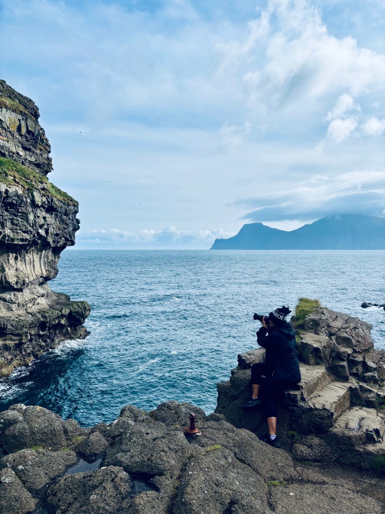
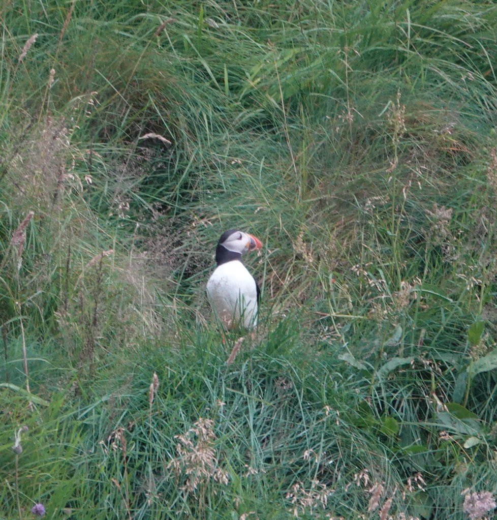
Details of this day can be found here. Visiting the villages of Gjógv and Saksun was definitely a highlight of the day, along with finally getting to photograph Puffins and hear content in the village of Gjógv.
✈️ Day 5 – Departure
Morning transfer back to Vágar Airport
Farewell to the islands — carrying memories of puffins, waterfalls, and windswept landscapes
Useful webpages and blogs
These are some of the sites and blogs I used when I started planning my trip
🏛 Official & Practical Sites
Visit Faroe Islands – The official tourism board with guides on transport, accommodation, events, and culture.
Guide to Faroe Islands – Local booking platform for tours, car rentals, and curated itineraries.
Atlantic Airways – National airline with direct flights from Copenhagen, Edinburgh, Paris, and Reykjavík.
Smyril Line – Ferry service connecting Denmark, Iceland, and the Faroes.
Northtrotter Travel Guide – Best apps and websites for planning, including hiking maps and weather forecasts.
Salty Sarah – My Week in the Faroes – Personal reflections, logistics, and highlights from a week-long trip.
Full Suitcase – Itinerary Suggestions – Detailed 3–9 day self-drive itineraries with maps and practical tips.
The Common Wanderer – Road Trip Guide – DIY road trip itinerary with cultural stops and safety tips.
💡 Final thoughts and Reflections
The Faroes demand flexibility — weather reshapes plans, but surprises often lead to unexpected gems.
Combining guided tours with independent boat trips gave the perfect balance of structure and spontaneity.
Based on my experience, I would suggest spending at least 5-7 full days to be able to see everything this beautiful island has to offer. Here is are list of must-visit places and hikes
🏘 Must-Visit Villages
Gjógv (Eysturoy): Famous for its natural gorge and colorful houses.
Saksun (Streymoy): Lagoon surrounded by mountains, one of the most photogenic spots.
Kirkjubøur (Streymoy): Historic village with medieval ruins and the world’s oldest inhabited wooden house.
Gásadalur (Vágar): Home to the iconic Múlafossur waterfall.
Viðareiði (Viðoy): Northernmost village, known for dramatic mountain and sea views.
Bøur (Vágar): Charming turf-roof houses with views of Tindhólmur islet.
Funningur & Elduvík (Eysturoy): Small, authentic villages with fjord views
🥾 Must-Do Hikes
Sørvágsvatn (Leitisvatn): The “floating lake” above the ocean, moderate 2-hour hike.
Slættaratindur: Highest peak in the Faroes (880 m), panoramic views across the islands.
Kallur Lighthouse (Kalsoy): Iconic cliffside hike with dramatic views.
Villingardalsfjall Summit (Viðoy): Panoramic northern island views.
Drangarnir Sea Stacks (Vágar): Challenging hike to dramatic sea arches.
Mykines: Puffin paradise with cliffside trails (weather-dependent)
🌍 Must-Visit Places
Múlafossur Waterfall (Vágar): Cascades directly into the ocean.
Fossá Waterfall (Streymoy): Tallest waterfall in the Faroes.
Tinganes (Tórshavn): Historic district with turf-roofed government buildings.
Nordic House (Tórshavn): Cultural center showcasing Faroese art and music.
Kalsoy’s Kópakonan Statue: Seal Woman monument tied to Faroese legend.
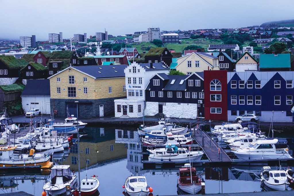
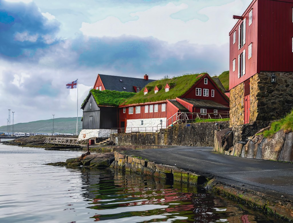
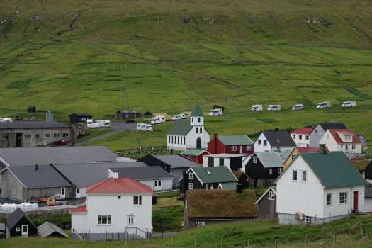
Tórshavn is the capital city and cultural heartbeat of the Faroe Islands. Despite its size, Tórshavn buzzes with cozy cafes, colorful turf-roofed houses, and a beautiful harbor. I stayed in the heart of the city in Hotel Hofnia and managed to walk everywhere. I loved how compact and walkable the downtown area was and I walked the downtown multiple times at all hours including at 4 AM on the first day (jet-lagged and couldn’t sleep). It is a very safe town. Tórshavn derives its name from Thor– one of the principal gods in Norse mythology. It also derives from the Scandinavian word “havn” for harbor. The name reflects the town’s Viking origins and its strategic coastal location
There is a lot to do in Tórshavn. Even though I spent only 3 days in these islands, staying in the heart of downtown allowed me to wander around this charming capital city. I managed to see some of the city’s highlights.
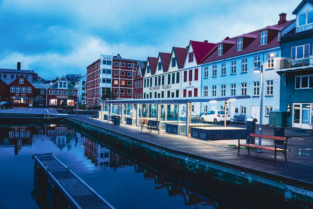
The colorful harbor front of of Tórshavn, , is a compact, scenic area defined by the historic Tinganes peninsula. The harbor area is divided into two parts, the eastern (Eystaravág) and western (Vestaravág) harbors. The eastern (Eystaravág) is the city’s commercial heart and a hub of activity. It is the functional side of the port where bus and ferry terminal, acting as the main public transport hub for the Faroe Islands. You can also see the Skansin fortress and the lighthouse on the eastern side. The western side of the harbor is dominated by cute cafes, restaurants, and shops.
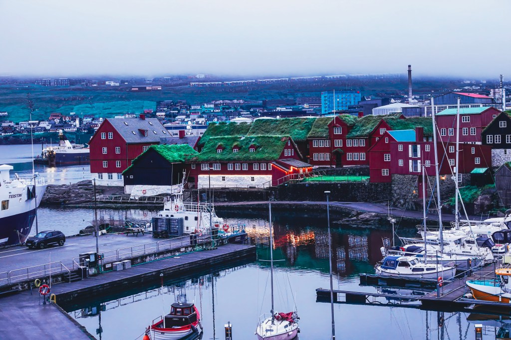
Historic Tinganes peninsula
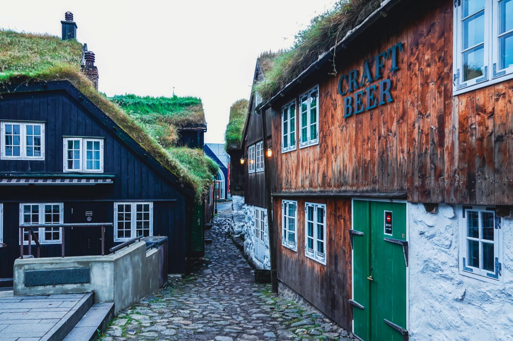
The windswept peninsula of Tinganes is more than just a picturesque assembly of turf-roofed houses. It is the beating heart of Faroese history. It represents one of the world’s oldest parliamentary meeting sites. As I wandered through the old town of Tinganes in Torshavn, I felt like I had stepped into a fairytale. The narrow lanes and wooden buildings were enchanting. Centuries of history whispered from every corner. For over a millennium, this rocky outcrop has been the island’s center for law and governance. Viking Age settlers first established their Ting (parliament) here around 825 AD. In the same narrow, cobbled lanes, the Faroese Home Rule government still meets. Viking leaders once convened the Althing here. Ministerial offices are housed in the iconic red-painted wooden buildings that date back to the 16th and 17th centuries.
The Timeless Streets of Undir Ryggi: Tórshavn’s Oldest Quarter
Undir Ryggi is a charming, historic neighborhood in Tórshavn, forming part of the city’s Old Town alongside the Reyn district. Nestled on a hillside near the harbor, the neighborhood is defined by its small, traditional Faroese houses. Many of these houses are centuries old. They are still inhabited today. The buildings are often tarred black with crisp white window frames. They feature classic grass roofs. This creates a wonderfully picturesque and time-honored scene. Visitors can explore the narrow lanes and passageways. These paths are winding, cobbled, and crisscross the area. They offer a peaceful glimpse into Tórshavn’s past. Undir Ryggi is easily accessible from the harbor.
Havnar Kirkja: The Historic Heartbeat of Tórshavn
Located right behind the Hotel Hafnia, I could see this church every morning from the window. This church dominates the harbor skyline and the surrounding area,
Standing proudly by the harbor, Tórshavn Cathedral (Havnar Kirkja) is one of the Faroe Islands’ most treasured landmarks. It is a must-see for visitors exploring the capital. Built in 1788, this elegant white church stands with a striking grey roof. It features a golden clock tower. It is the second-oldest church in the Faroe Islands still in use.
I didn’t get a chance to see the inside. Based on what I read, interior is filled with maritime touches. Ship models hang from the ceiling. Warm wooden pews reflect the islands’ deep seafaring roots. The cathedral remains the seat of the Bishop of the Faroe Islands. It continues to host services. It also hosts concerts and community gatherings.
Skansin Fort: Tórshavn’s Historic Guardian of the Sea
From its grassy perch overlooking Tórshavn harbor, Skansin Fort is a living chronicle of the Faroe Islands’ layered past. Built in 1580 to fend off pirate raids, this strategic outpost has weathered centuries of change. It survived a destructive encounter with French pirates. It also played a pivotal role as a British military headquarters during World War II. As you stroll the ramparts, you can examine the historical cannons—some from the Danish trade monopoly, others powerful 5.5-inch naval guns left by the British—that still stand guard over the sea lanes. The highlight, however, remains the stunning panoramic views. With the iconic red-and-white lighthouse as your focal point, you can take in sweeping vistas of the bustling port, the picturesque town, and the distant, rugged outline of Nólsoy island on the horizon
Visit Kongaminnið Monument
The photo above shows the view of the Kongaminnið monument from my room. I didn’t visit the monument, but it offers a great view of the city and the harbor. The Kongaminnið monument is a basalt obelisk. It was erected in 1882 to honor Danish King Christian IX’s visit to the Faroe Islands in 1874. This visit was the first by a Danish monarch. The king’s visit to Tórshavn had some dramatic moments. During the welcome speech, the mayor fainted and tragically died in front of the King and the crowd. King Christian IX was deeply affected and supported the mayor’s widow financially for the rest of her life.
Gamli Bókahandil and Paname cafe
Officially known as H.N. Jacobsens Bókhandil, Gamli is the oldest bookstore in the Faroe Islands. It is also a cultural gem in the heart of Tórshavn.
The shop was founded in 1865 by Hans Nicolai Jacobsen. He was a bookbinder and cultural advocate. The shop began in the historic Gongin street. It later moved to its current location in Vaglið square. Here, it resides in a charming red building with a turf roof.
Today, Gamli Bókahandil offers a wide selection of books in Faroese, Danish, and English. It also provides stationery, gifts, toys, and art prints. I bough postcards and stamps and mailed them to my family and friends from the postbox located in the bookstore. I bought the book “Land of May be” by Tim Ecott here (This is a popular book about Faroese culture and heritage). The book store is attached to another of my favorite places in Torshvn, the Paname Cafe. Paname Café blends French interior design with Faroese hospitality. It’s a family-run café offering homemade pastries, sandwiches, tapas plates, and organic coffee and tea, along with a curated selection of French wines and local beers
The National Museum of the Faroe Islands
The National Museum of the Faroe Islands (Tjóðsavnið) in Tórshavn offers a rich and immersive journey through the islands’ natural and cultural history. I didn’t get a chance to check this place out, but it comes highly recommended as one of the must-visit places
Located at Brekkutún 6, the museum features a permanent exhibition that spans geology, botany, zoology, archaeology, and folk life. Visitors can explore the volcanic origins of the islands, view native bird and marine life, and discover artifacts from the Viking Age and Middle Ages, including bone combs, beads, and farming tools.
One of the museum’s most treasured displays is the Kirkjubøstólarnir — intricately carved pew ends from the 15th century, originally part of St. Olav’s Church in Kirkjubøur. These pieces are considered national treasures, reflecting the craftsmanship and religious heritage of medieval Faroese society.
Restaurants of Tórshavn
I stuck with mostly Cafe Kasper, which is right next to Hotel Hofnia, and had some great options for vegans and vegetarians. Another restaurant I tried was Etika, a sushi restaurant right opposite Hotel Hofnia. Here are a few others that are quite popular in the downtown and surrounding area
KOKS: Michelin-starred and world-renowned, KOKS serves a tasting menu rooted in Faroese heritage, including fermented lamb, seaweed, and local seafood.
Áarstova is set in a historic turf-roofed house. This cozy spot specializes in Faroese lamb and fish dishes. The ambiance is rustic.
Ræst: A unique restaurant dedicated to traditional Faroese fermented cuisine, offering bold flavors in a timber-clad setting.
Barbara Fish House: Located in the old town of Tinganes, this charming seafood restaurant offers fresh fish, mussels, and Faroese-style sushi.
Etika Sushi is the only sushi restaurant in the Faroe Islands. It blends Japanese techniques with Faroese ingredients, such as salmon and sea urchin.
Fríða Kaffihús: A cozy café perfect for coffee, tea, and light snacks, with a relaxing vibe and great pastries.
Húsagarður: A stylish European grill offering seasonal menus and wine pairings, ideal for a refined evening out.
Katrina Christiansen: A solo-diner-friendly restaurant with a vegan menu and affordable Faroese dishes.
Roks: KOKS’ more affordable sister restaurant, offering high-quality Faroese cuisine in a relaxed setting.
Irish Pub Tórshavn: A lively spot for beers, pub food, and live music — great for socializing
Final Thoughts: Why Tórshavn Captivates
Tórshavn may be one of the smallest capitals in the world, but it pulses with history, hospitality, and heart. From Viking-age parliament sites to turf-roofed homes and cozy cafés, every corner of this walkable city invites exploration. Staying at Hotel Hafnia placed me in the center of it all. It allowed me to wander at all hours. I could soak in the harbor views and discover the soul of the Faroe Islands.
Whether you’re sipping organic coffee at Paname Café or browsing books at Gamli Bókahandil, hiking up to Skansin Fort, or dining at the world-renowned KOKS, Tórshavn offers a rich blend of tradition and modernity. Even in just three days, I felt deeply connected to the rhythm of this city — its quiet mornings, dramatic skies, and welcoming people.
My recent adventure through this Nordic paradise was nothing short of magical. Here are the highlights from my journey through some of the most captivating corners of the Faroes. I took 7-hour Highlights of the Faroe Islands tour and visited some of the most spectacular places in the Faroese. The journey to some of the remote villages themselves is an adventure, including driving through the world’s first underwater roundabout.
The day started with a pick up from my hotel in Torshavn at 8.30. We were only 3 people on this tour which made it very intimate and personal. We had an amazing guide, Barbara. She was a Faroese native and entertained us throughout the day with fun and interesting stories about her country.
Opened in December 2020, the Eysturoyartunnilin is an 11.2 km (6.9 mile) long undersea tunnel that dives 189 meters (620 feet) beneath the North Atlantic. It links the capital Tórshavn with the towns of Runavík and Strendur, dramatically reducing travel time from over an hour to just 15 minutes2.
At the heart of this tunnel lies the world’s first underwater roundabout. It is a glowing circular junction. This junction connects three branches of the tunnel. The centerpiece is a giant natural rock pillar. It was left intact during construction. Faroese artist Tróndur Patursson transformed it into a stunning art installation. His 80-meter steel sculpture features life-sized figures holding hands around the pillar, symbolizing unity and the Faroese spirit of cooperation. Watch the video below with sound on. Our fabulous guide Barbara was singing a traditional Faroese song that is linked to this artwork
Song linked to underwater roundabout
Gjógv: Gorgeously Remote
First stop on our highlight tour is the village of Gjógv, named after its dramatic sea-filled gorge, is a village that feels like the edge of the world. The gorge itself is a natural harbor, and the views from the cliffs above are breathtaking. I sat on the famous bench overlooking the Atlantic, watching puffins and taking tons of photos. My day 1 trip to Mykines Island was canceled because of the weather. I had been dying to photograph puffins, and finally, I had my chance in Gjógv. Below is the picture of me taking photos of Puffins and behind me the Kalsoy island, where James Bond meets his inevitable demise in No Time To Die
The entire town is beautiful and there are lots of hiking trails if you want to enjoy nature and the surrounding area. If you want to stay in the village, there is one hotel Gjaargardur Guesthouse,that also has an on-site cafe and restaurant.
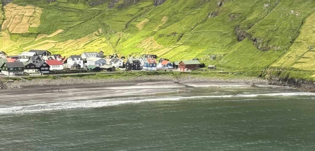
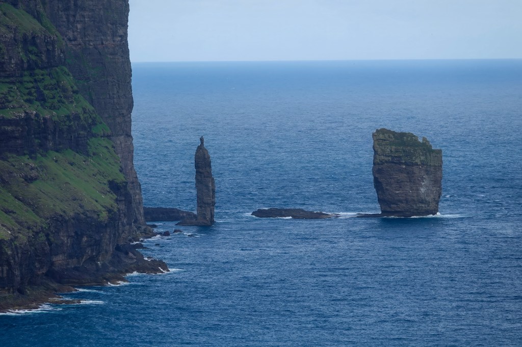
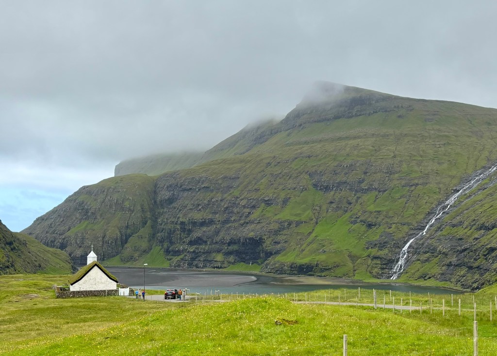
Tjørnuvík: Black Sands and Viking Echoes
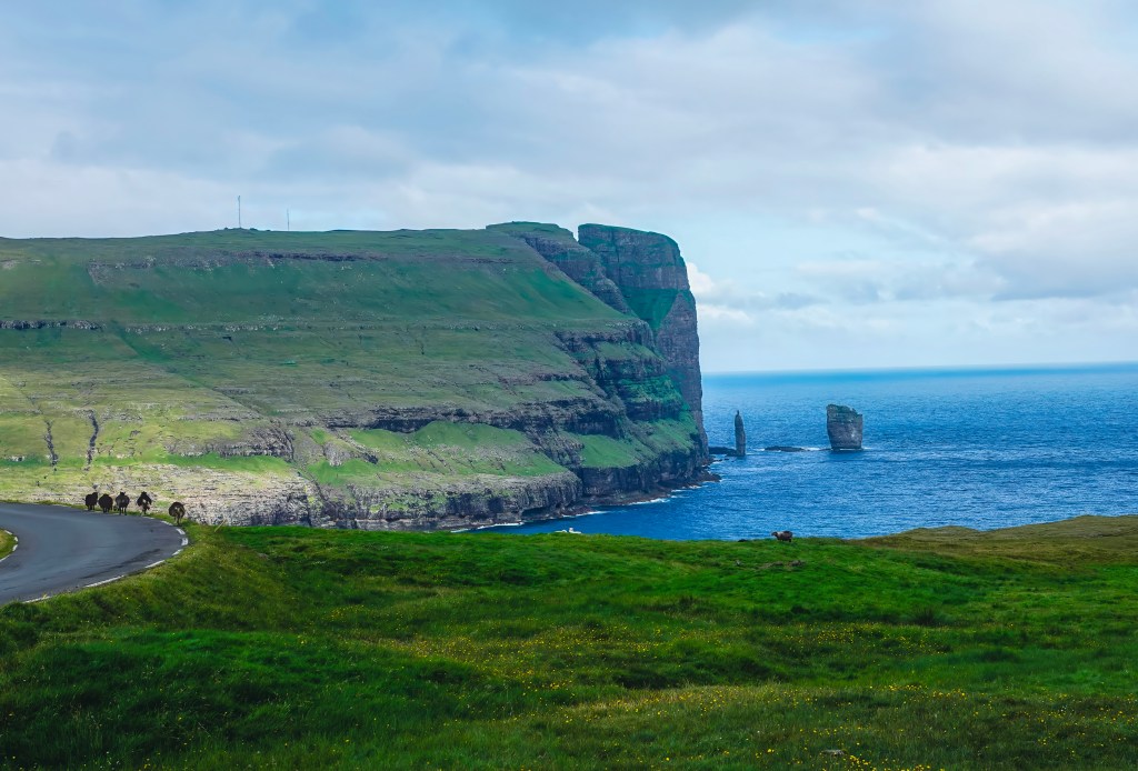
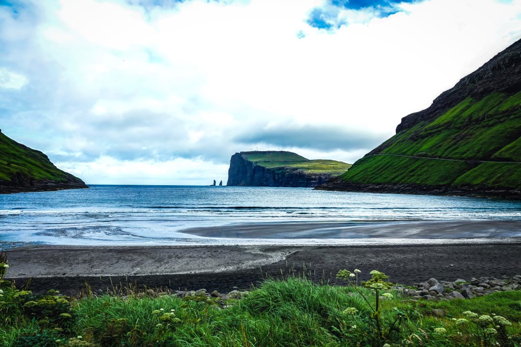
Tjørnuvík is the northernmost village on Streymoy and boasts a stunning black-sand beach framed by steep mountains. From here, you have a view of the iconic sea stacks. They are called Risin og Kellingin, also known as “The Giant and the Witch” which rise impressively from the ocean. According to Faroese folklore, a giant and his witch wife were sent from Iceland to steal the Faroe Islands. As they tried to drag the islands back home, they were caught by the rising sun and turned to stone—forever frozen in their attempt.
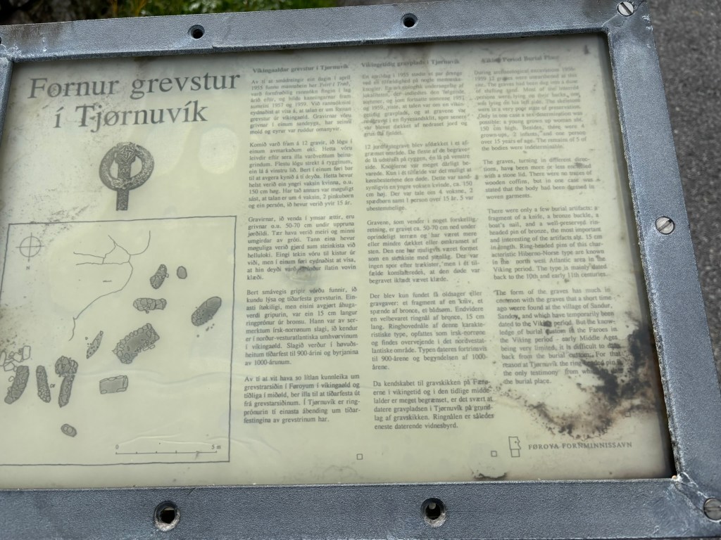
Viking burial site
Near the Tjørnuvík beach, you can also see a Viking burial site. This burial site was uncovered in 1950s and gives you glimpse into the lives and culture of early Norse settlers.
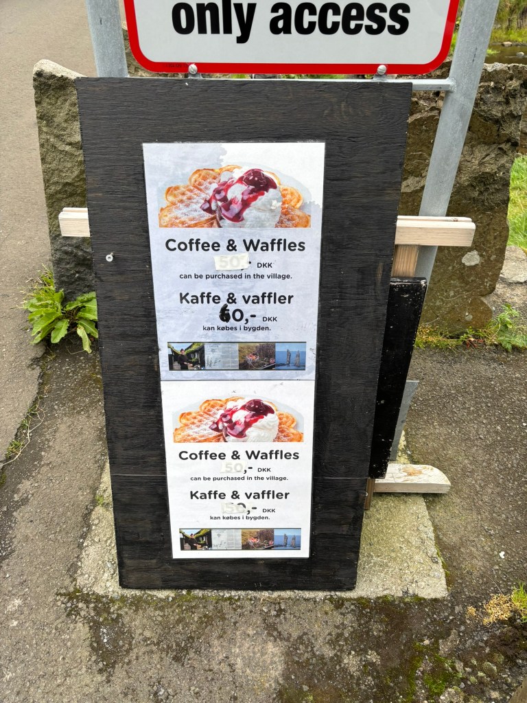
The village also has a surf shop and a cute little cafe that serves waffles and coffee run by a local man (Cash only service)
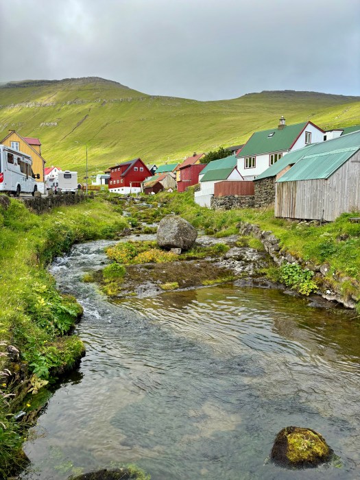
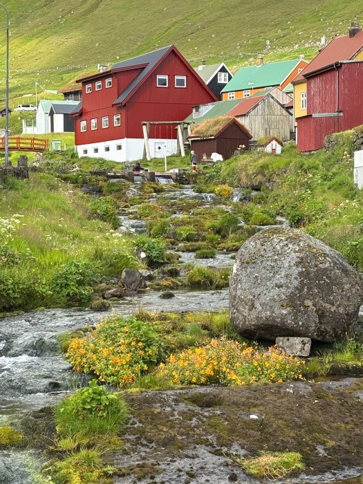
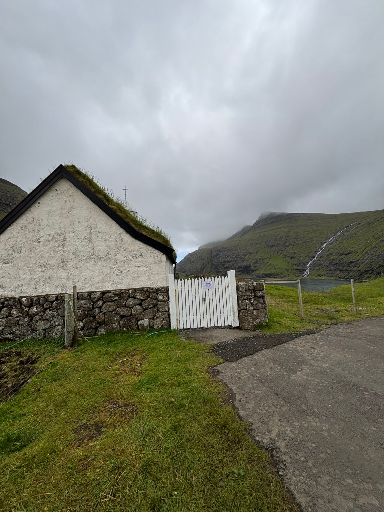
Saksun: Serenity in a Natural Amphitheater
Next stop: Saksun. This tiny village is tucked into a valley surrounded by towering mountains and overlooks a tidal lagoon that was once a fjord. With only 11 people and an old church perched above the lagoon, it is postcard-perfect village, and the hike down to the black-sand beach is surreal, especially when the tide is out.
A highlight for hiking enthusiasts is the hiking trail from Saksun to Tjornuvik. This hiking path winds through mountain trails marked by cairns and offers fantastic views of the surrounding mountains and fjords.
The Village Church of Saksun possesses a distinctive historical significance. Initially situated in Tjørnuvík, the church was carefully dismantled and relocated via a mountain hiking trail to its present site in Saksun. It was subsequently re-consecrated on the third Sunday after Trinity in 1858. The original trail over the mountains remains accessible today and is widely regarded as one of the most picturesque routes in the Faroe Islands. Notably, the church now features exterior stone walls, reflecting a transition from earlier wooden construction methods. Elements such as the interior walls, support beams, and altar continue to evoke the church’s origins in Tjørnuvík.
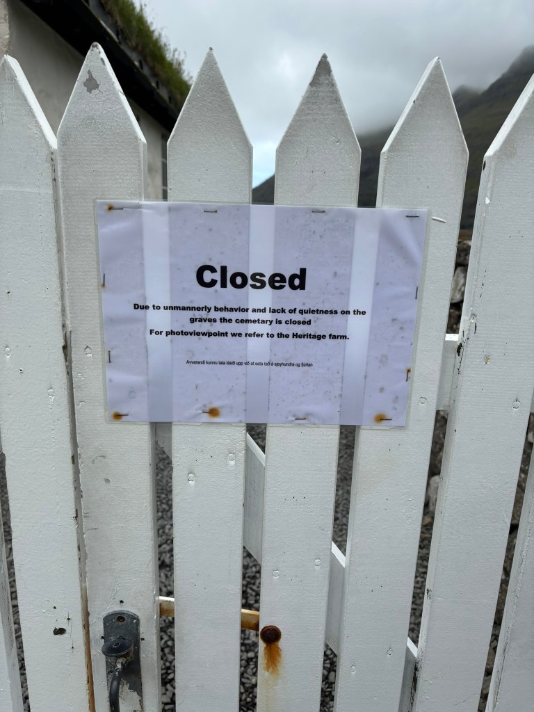
The church is not open to public anymore due to an incident that happened few years ago and you can only see it from outside
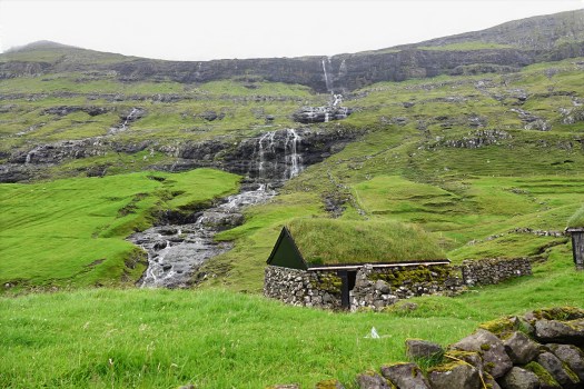
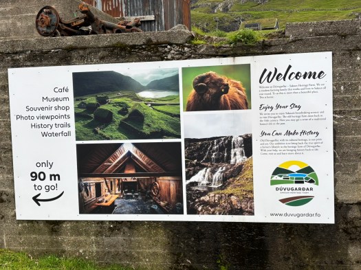
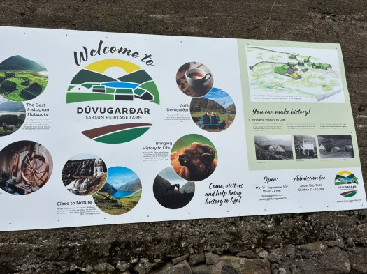
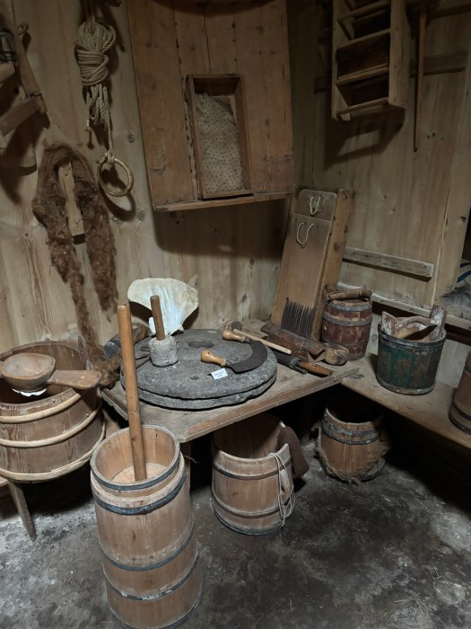
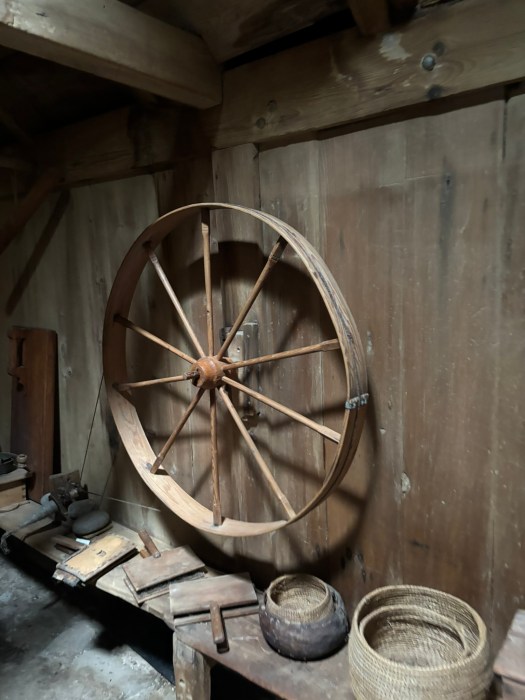
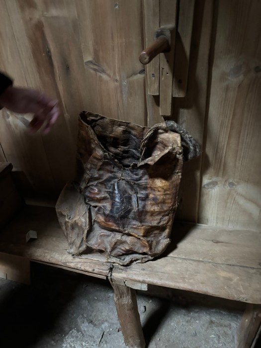
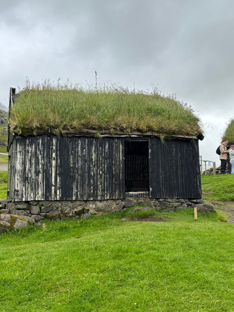
Dúvugarðar: A Living Testament to Faroese Farming Traditions
Saksun is also home to Dúvugarðar farm, which dates back to the 16th–18th century and stands as a remarkable testament to traditional Faroese farming life. Throughout the centuries, this historic site has preserved the essence of rural life in the Faroe Islands, highlighting authentic agricultural practices and enduring craftsmanship. The farm’s architecture and layout embody the methods and customs that influenced generations of Faroese farmers, offering visitors a unique window into the daily rhythms and cultural heritage of the region.
The Farmhouse: From Communal Home to Museum
Once home to dozens of people living under a single roof, the farmhouse now functions as an open-air museum. Visitors can explore a variety of carefully preserved and restored historical rooms. Each space features period textiles, authentic furniture, and traditional tools, allowing guests to immerse themselves in the daily life and craftsmanship that defined the farm through the centuries. The museum setting provides a tangible connection to Faroese domestic life as it once was.
Exploring the Landscape and Amenities
Visitors are invited to walk along history trails leading to a nearby waterfall, which offers breathtaking views and opportunities to capture iconic photos of the grass-roofed buildings against the stunning valley landscape (This spot is insta famous but was roped off when I was visiting and I was unable to take the iconic photo). Additional amenities at Dúvugarðar include a café serving light meals and hot beverages, as well as a small souvenir shop featuring locally handmade items.
Practical Information
The farm is accessible via a picturesque single-lane road, with parking available on-site. The main entrance charges an adult fee of 150 DKK, while access to the paths leading to the waterfall and nearby beaches remains free for all guests. This was one of the most picturesque places in the Faroe Islands and a popular spot for Instagram photos. The museum is definitely worth going through.
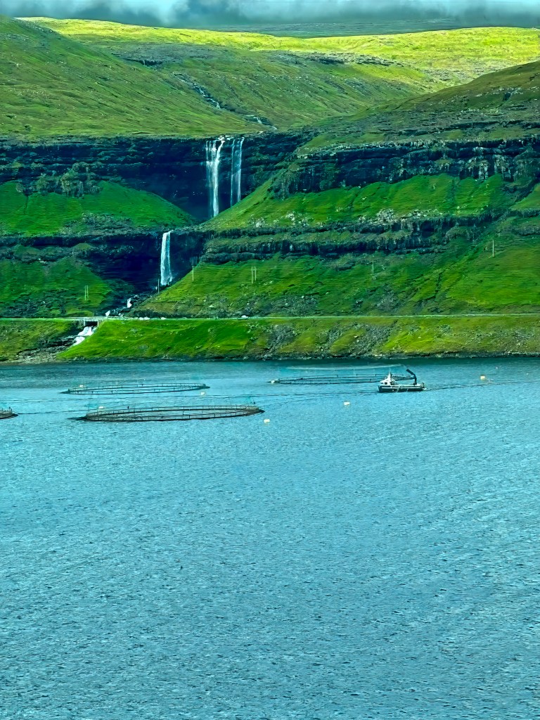
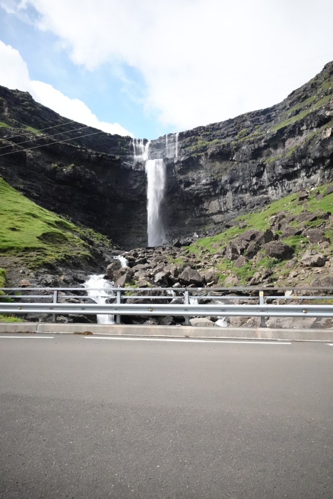
Fossá Waterfall: The Tallest Cascade in the Faroes
No trip is complete without witnessing the majestic Fossá Waterfall, the tallest in the islands. Cascading in two tiers down a cliffside, it’s a powerful sight—especially after rain. The waterfall is located right next to the road and doesn’t require much hiking to view it. The best photograph I took of these falls was actually from the other side of the lake where you can see the entire waterfall or with a drone where you can capture the different tiers of the waterfall.
Funningur: Tranquility in the Heart of Faroe Mountains
On the way back from Gjógv , we stopped at a carstop and crossed to the other side to get the panoramic view of the village of Funningur and its surroundings. The winding road slides its way down the mountainside from the highest mountain of Faroe Islands known as Slættaratinduor, rising 880m (2887 feet) above sea level. You can use this road to reach the village. You can also hike from the car stop to Hvíthamar, which is a very popular and easy hike.
Hvíthamar Hike: Quick Overview
The Hvíthamar hike (Gongturur route) is a short, scenic trail above Funningur in Eysturoy, covering 2 km with an elevation gain of 124 meters. Trail completion typically takes about an hour, reaching up to 428 meters before looping back to Gjáarskarð pass.Getting There
Start at Gjáarskarð mountain pass between Funningur and Gjógv. Limited parking is near the cattle grid; green posts and a stile mark the trailhead. From Tórshavn, drive about 40–45 minutes and choose between the toll Eysturoyartunnilin or Streymin Bridge.
Highlights
Hvíthamar Ridge Viewpoint: A metal railing marks a vista over Funningsfjørður fjord, Funningur, and nearby peaks, just 10 minutes from the trailhead.
Skeggjanøv Viewpoint: After another 10–20 minutes uphill, enjoy extended views to Kalsoy Island.
Buttercup Road-High Mountain road
The “Buttercup Road” refers to a signposted network of scenic routes in the Faroe Islands, not a single specific road. These roads are marked with a yellow buttercup flower and are known for offering breathtaking views as they wind through mountains and to remote coastal villages. Some examples include the mountain road (Oyggjarvegur) above Tórshavn and routes to scenic villages like Saksun and Tjørnuvík.
We took the mountain road (Oyggjarvegur) after visiting Saksun on our way to Kirkjubøur. We joined this mountain at the gas station near Lake Leynavatn and drive 18 km (11 mi) of paved surface, connecting Tórshavn. We stopped at couple spots but the memorable spot for me was valley of Mjørkadalur. You can also see the huge windmill park on this road.
Prison-Panorama View over Kaldbaksbotnur, Coolest Prison in the World
The prison lies in an area called Mjørkadalur, which means the “Valley of Fog” since clouds tend to form near the surrounding mountain peaks above the fjord of Kaldbaksfjør∂ur.
There are about 13 prisoners in this prison, and each gets their own individual cell with a working television. They also have a mini-golf course out back to while away the hours. It is most beautiful prison I have seen and asked our guide how do get a room in that prison:-) which had better views than a 5-star hotel.
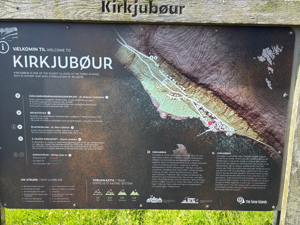
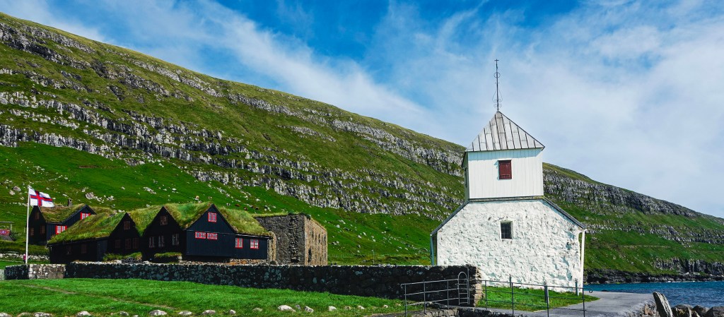
Kirkjubøur: Echoes of the Past in the Faroese Landscape
This was the last stop on our Faroe Islands highlight tour, but closest to the capital Torshavn. It is the Faroe Islands’ most historically rich village. It is a must-visit for any traveler seeking a deeper connection to the islands’ past. Kirkjubøur is perched on the edge of the sea with sweeping views of Hestur and Koltur. It is home to three remarkable landmarks.
The ruins of Magnus Cathedral
Also known as The Múrunin (Wall), the ruins of unfinished Magnus Cathedral can be seen right behind the St. Olav’s church. Built around the 1300s, it was reputed to have been one of the finest churches in Scandinavia.
Saint Olav’s Church
Another landmark is Saint Olav’s Church, the oldest still-used church in the Faroese, dating back to the 12th century. You can see an impressive altarpiece painting by the famous Faroese artist Samuel Joensen Mikines inside the church.
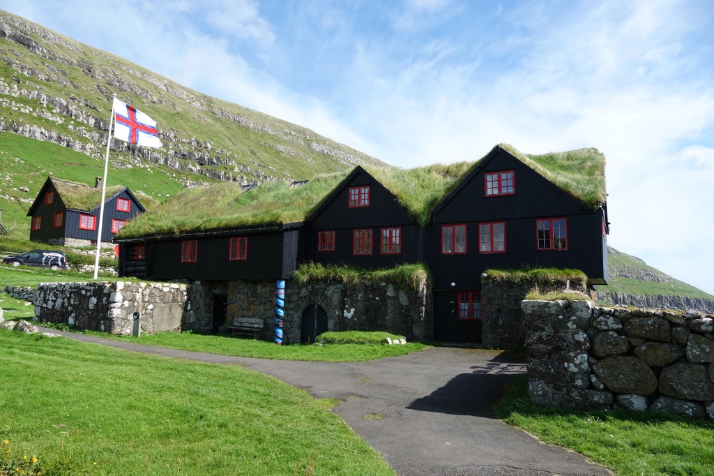
Kirkjubøargarður
Also known as King’s farm, Kirkjubøargarður, is a turf-roofed farmhouse that’s been continuously inhabited for nearly a thousand years. The current owners are the 13th generation of the Patursson family. It is one of the oldest inhabited wooden houses in Europe. You can walk through the house and appreciate the history and legends surrounding this charming house.
Walking through this village feels like stepping into a living museum. History, nature, and tradition blend seamlessly into the landscape.
Final Thoughts
The Faroe Islands are a place of contrasts—wild yet peaceful, remote yet welcoming. Whether you’re chasing waterfalls, exploring Viking history, or simply soaking in the silence, this archipelago offers a kind of magic that lingers long after you leave.
If you’re craving a destination that’s off the beaten path and rich in soul-stirring landscapes, the Faroes are calling. And trust me, you’ll want to answer.
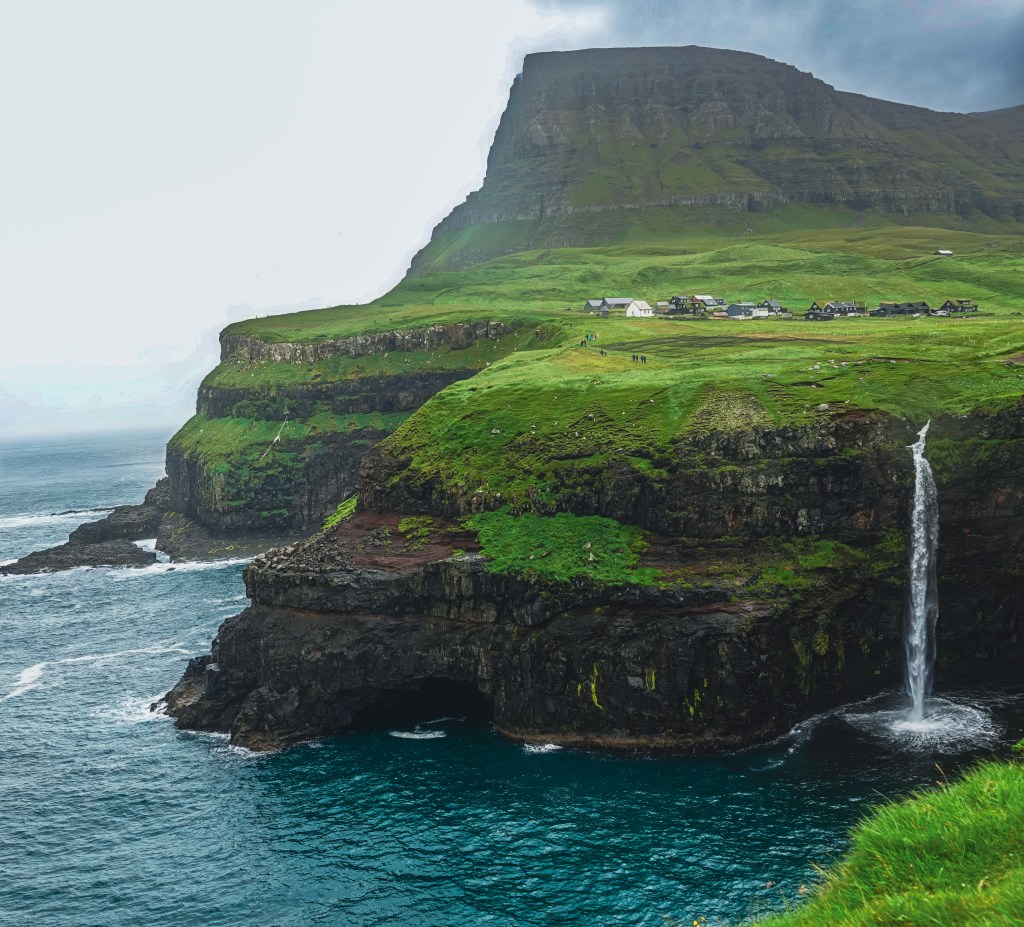
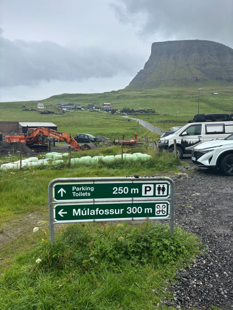
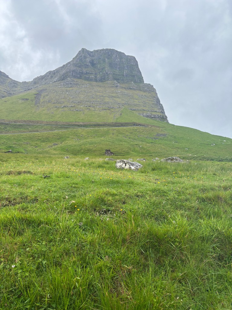
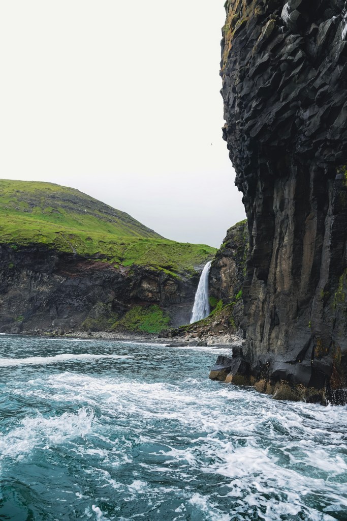
Múlafossur Waterfall is a dreamy waterfall tucked away on the rugged western edge of Vágar Island in the Faroe Islands. The waterfall plunges dramatically into the Atlantic Ocean, surrounded by cliffs and a tiny, charming village of Gásadalur. I got to see the waterfall twice. First, I saw it from the ocean when I was on the Classic Drangarnir Sea Arch Boat Tour. Then, I saw it again from the land after visiting the Lake above the ocean. I also visited the village of Bøur. It is one of my favorite villages in the entire Faroe Islands. Both the sea views and the land views offer different perspectives of both the waterfall and the villages.
Múlafossur: The Promontory Waterfall
With a drop of 60 meters (200 feet), Múlafossur is the Faroe Islands’ most iconic natural wonder. Its name translates to “Promontory Waterfall.” The name is fitting as it cascades off a cliffside directly into the tempestuous sea below.
Gásadalur: The Goose Valley
Gásadalur was once accessible only by hiking over the steep mountain passes. Now, the village welcomes visitors through the Gásadalstunnilin tunnel(Built in 2006). This makes the journey far easier— but no less magical. With about 20 residents and 25 houses, this remote village offers a rare glimpse into traditional Faroese life. You can actually stay in this village. There are 2 options. One is Múlafossur Cottages, located next to the stream. The other one is Hjalgrímsstova, part of the modern sheep farm Gásadalsgarðu.
The name Gásadalur means “Goose Valley,” and the charm here is undeniable. A cozy café and guesthouse serve locally sourced lunches, cakes, and coffee. These treats are perfect for warming up after a brisk walk to the waterfall.
Mountains That Guard the Valley
Gásadalur is cradled between two majestic peaks:
Eysturtindur (“The Peak to the East”) rises to 715 meters (2346 feet)
Árnafjall, the highest mountain on Vágar, reaches 722 meters (2368 feet)
These mountains not only add drama to the landscape but also serve as silent sentinels, watching over the village and its waterfall.
When to Visit
Gásadalur and Múlafossur can be visited year-round. Summer offers longer daylight hours and milder weather, while winter cloaks the village in mist and mystery. No matter the season, the waterfall’s roar and the village’s quiet beauty promise a moment of awe.
Whether you’re chasing waterfalls or seeking solitude, Múlafossur and Gásadalur deliver both. You can combine a visit to the village and the waterfall with a visit to the village of Bøur
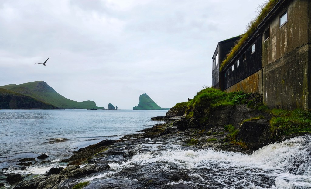
Bøur: The Coastal Hamlet with Legendary Views
Bøur is just a short drive from Vágar Airport. It lies along the same stretch of coast as Gásadalur. Bøur is a tiny village steeped in history and natural beauty. Around 70 residents live in Bøur. It is famous for its picturesque turf-roofed houses. These houses are clustered near a small beach and a charming 19th-century church.
From Bøur, visitors enjoy breathtaking views of the jagged islets Tindhólmur and Drangarnir, iconic sea stacks that have inspired countless photographs and paintings. The village’s peaceful atmosphere and scenic surroundings make it a favorite stop on Faroe Islands sightseeing tours. Village of Bøur, has couple of restaurants and cafes that you could and enjoy a meal. We stopped here and had a picnic lunch on the black sand beach after out visit to the Mulafossur and took some great photos of Drangarnir from the beach.
Public Transport & Driving
From Vágar Airport: Both Bøur and Gásadalur are easily accessible by car, making them ideal stops for travelers. The drive to Bøur takes about 15 minutes, allowing you to enjoy stunning views along the way. Continuing on to Gásadalur adds another 5 minutes. This brings the total travel time to 20 minutes through the scenic Gásadalstunnilin tunnel. The tunnel offers a unique experience as you pass beneath the mountains.
Road Conditions: Roads are well-maintained but narrow and winding. Drive cautiously, especially in foggy or wet conditions.
Parking: Designated parking areas are available near both villages. From the Gásadalur parking lot, it’s a short walk to the Múlafossur viewpoint.
By Bus:
Bus 300 from Vágar Airport to Sørvágur
Bus 350 from Sørvágur to Bøur (runs 3x/day on weekdays)
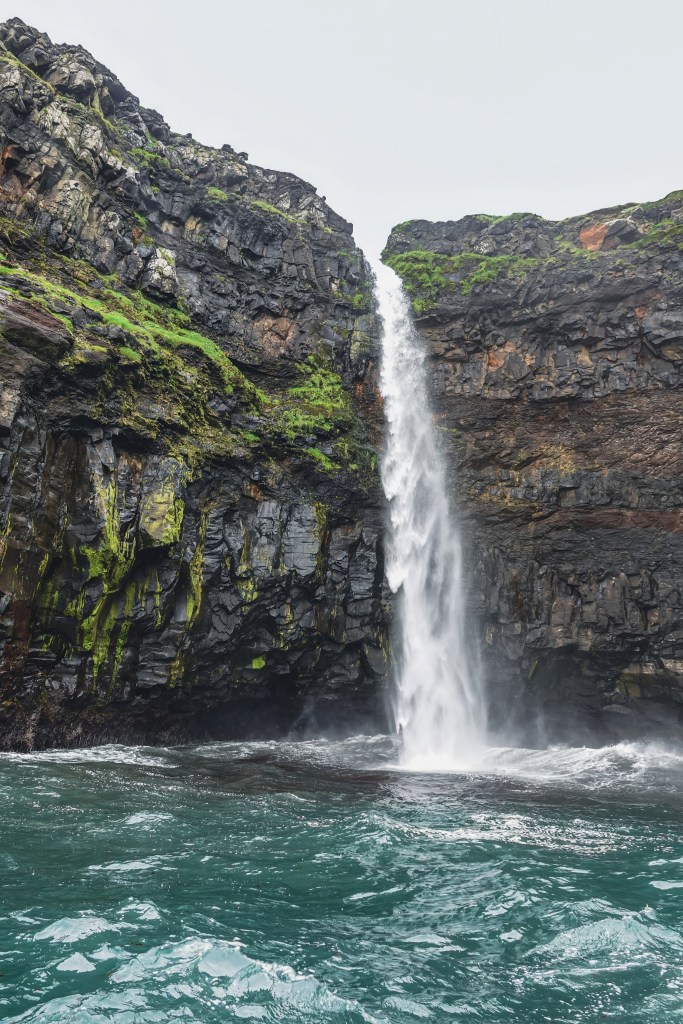
How to Visit: By Boat
Boat Tours: Several local operators offer boat tours from Sørvágur or Vágar harbor. These tours cruise along the coast and give stunning views of Múlafossur, Drangarnir, and Tindhólmur from the sea.
Highlights:
See Múlafossur waterfall from below as it crashes into the ocean.
Sail past dramatic cliffs and sea stacks.
Spot puffins and seabirds nesting on nearby islets.
Season: Most boat tours run from May to September, weather permitting.
The Postman’s Trail: A Historic Hike Between Bøur and Gásadalur
Before the tunnel was built in 2004, Gásadalur was completely isolated, accessible only by boat on calm days or by foot over the mountains. The most famous route was the Postman’s Trail, a rugged path that connected Bøur to Gásadalur.
Distance: ~5 miles round-trip
Duration: 3.5 to 4.5 hours
Difficulty: Moderate to challenging (steep climbs, uneven terrain)
Trailhead: Just past Bøur, near the tunnel entrance (look for cairns and a narrow dirt path)
Summits Nearby: Mt. Rógvukollur (464 m) and Knavin (485 m) offer optional detours with panoramic views
The postman hiked this trail three times a week, delivering mail to Gásadalur’s residents. Along the way, he would pass dramatic cliffs and windswept ridges. He would eventually descend into the valley where Múlafossur Waterfall roars into the sea. It was a view he knew well.
Today, hikers can retrace his steps and experience the Faroe Islands as they were before modern roads. It’s a journey through history, solitude, and raw nature.
Where to Stay: Gásadalur & Bøur
Whether you’re seeking solitude by the sea or a warm cottage nestled beneath misty mountains, both villages offer unforgettable accommodations.
🌿 Gásadalur Stays
Lundi Cottage – Turf Cottage by Múlafossur Waterfall A guest favorite on Airbnb, this charming turf-roofed cottage sits right beside the famous waterfall. Expect sheep, birds, and highland cows as neighbors, plus views that feel like a painting.
Múlafossur Cottages These well-crafted holiday homes offer spacious interiors, warm ambiance, and unbeatable proximity to the waterfall. Ideal for relaxing after a day of hiking or sightseeing.
Gásadalur Apartments @ World Famous Waterfall Air-conditioned apartments with balconies and full amenities, located steps from the waterfall. A perfect blend of comfort and location.
Nearby Options in Sørvágur & Sandavágur If Gásadalur is fully booked, nearby towns offer excellent alternatives:
Guesthouse Hugo – Cozy, social atmosphere with sea views
Cottages by the Sea – Waterfront serenity with mountain views
Giljanes Camping & Hostel – Budget-friendly with shared kitchen and lounge
🏡 Bøur Stays
The View to Drangarnir, Tindhólmur & Mykines These are a cluster of four traditional Faroese turf-roofed houses. They are built to blend into the landscape. These homes offer panoramic views of the famous sea stacks and are among the highest-rated stays in the Faroe Islands.
Airbnb Options in Bøur Bøur features several unique rentals with rustic charm and modern amenities. Many offer full kitchens, cozy living spaces, and direct views of the ocean and nearby islets.
Nearby Sørvágur Accommodations Just a short drive away, Sørvágur offers:
Løðupackhouse – Historical Warehouse – A renovated 100-year-old harbor house
Perlan Apartments – Sea-view apartments with full kitchens
Pouls Airport Guesthouse – Convenient for travelers, with car rental options included
Skarðsáfossur: The Hidden Waterfall of Vágar
While Múlafossur steals the spotlight, Skarðsáfossur is just a short distance away. It is a lesser-known but equally breathtaking waterfall. It tumbles from the cliffs onto a small black stone beach. This secluded cascade is positioned between Bøur and Gásadalur. It offers a more intimate and wild experience for those willing to seek it out.
Location & Landscape
Coordinates: Roughly 2 km west of Bøur, near the tunnel entrance to Gásadalur
Setting: Rugged cliffs, black stone beach, and panoramic views of Tindhólmur, Drangarnir, and the skerry Akranessker
Wildlife: Puffins and seals are often spotted in the area
The waterfall is best viewed after rainfall, when its flow is strongest and most dramatic.
Best Way to Visit: By Boat
Because the land surrounding Skarðsáfossur is private property, the best and most respectful way to see it is from the sea:
Boat Tours: Depart from Sørvágsfjørður and cruise past Skarðsáfossur, Drangarnir, and Tindhólmur
Experience: Boats can get close enough to hear the crashing water and feel the spray
Recommended Tour: Drangarnir Boat Tour includes Skarðsáfossur as a highlight
Land Access: A Rugged Adventure
While not officially marked, adventurous hikers sometimes approach the area from land:
Trailhead: Just before the tunnel to Gásadalur, near Bøur
Route: Hike down toward the ocean, aiming for the skerry Akranessker
Terrain: No visible path; grassy fields used for sheep herding, rocky coastline, and steep descents
Caution: Slippery rocks and private land—respect boundaries and avoid trespassing
Bluegate – Drangarnir & Múlafossur Boat Tour
Highlights: A 60–75 minute tour originates from Sørvágur marina. On this boat tour you will visit Bøur village, Múlafossur waterfall, Tindhólmur islet, and the Drangarnir sea stacks. Weather permitting, guests may sail through Drangarnir’s sea arch. Small boat size (12 passengers) ensures a personal experience. In the summer months, you may be able to see some puffins.
📌 Meeting Point: Sørvágur marina
☎️ Phone: 780800
🌐 Website: bluegate.fo
Seatravel – Exclusive Drangarnir Boat Tours
Highlights:1.5 hour tours from Sørvágur to Drangarnir, Múlafossur, Tindhólmur, and Akrans. Focuses on intimate small groups (max 16 passengers), guided by experienced captains.
📌 Meeting Point: Sørvágur marina
🌐 Website: seatravel.fo
Final thoughts
Exploring Múlafossur and the village of Gásadalur is like stepping into a living postcard—where nature’s drama meets quiet village charm. From the iconic waterfall plunging into the Atlantic to the serene beauty of Bøur and the tucked-away Skarðsáfossur, this corner of the Faroe Islands offers a rare blend of accessibility and mystery.
Whether you’re chasing waterfalls, hiking cliffside trails, or simply soaking in the silence, this guide is your invitation to slow down and let the landscape speak. The Faroe Islands aren’t just a destination—they’re a mood, a rhythm, a reminder that the most unforgettable places are often the ones that feel untouched.
So pack your layers, charge your camera, and bring your sense of wonder. Gásadalur and its neighbors are waiting.
The desktop background that set me on an adventure to the Faroe Islands…. You might have seen this lake as a desktop background. Once I saw it, I knew I had to visit. The entire trip was planned with a hike to the Lake above the ocean as the primary focus.
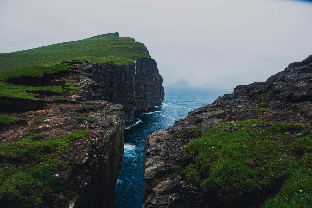
Lake Sørvágsvatn, the largest lake in the Faroe Islands, covers an impressive 3.4 square kilometers and appears to hover enchantingly over the North Atlantic Ocean from the dramatic heights of Trælanípa Cliff. This optical illusion is caused by the elevation of the lake compared to the sea. At its end the stunning 30-meter-high Bøsdalafossur waterfall that cascades gracefully down into the ocean. This picturesque viewpoint not only showcases the waterfall, but it also offers an awe-inspiring view of the sea stack Geituskoradrangur.
* The lake is known by two names, Sørvágsvatn and Leitisvatn, due to local preferences. Sørvágsvatn is preferred by the people of Sørvágur, while Leitisvatn is favored by those in Miðvágur and Sandavágur.
Hiking guidelines and starting point
You need to pay to do this hike as the lake and the cliffs sit on private property. There is a dirt parking lot at the beginning and a reception hut. You can buy tickets as well as get snacks and souvenirs from this small shop. More information can be found at the landowners’ web page.
The gate is open 24/7. If you want to do an early morning sunrise or sunset hike, you can still do the hike and pay later. (Honor system). It’s an easy hike with minimal elevation gain. However, wear proper shoes as the muddy path can get slippery when it’s raining.
How to get to Sørvágsvatn/ Leitisvatn lake
Public Bus Travel from Tórshavn
The main bus terminal in Tórshavn is known as Farstøðin. It serves public blue buses. These buses run between Tórshavn and villages on Vágar Island (where the lake is located).
You can take a bus from Tórshavn to nearby villages such as Miðvágur or Sandavágur. These villages serve as common starting points for hikes to the lake.
The ride from Tórshavn to these villages generally takes around 40 minutes to an hour. This includes travel through the underwater tunnel that connects Streymoy (Tórshavn’s island) and Vágar Island.
Self Drive/ Car
You can drive to the dirt parking lot, pay the fee at the entrance, and hike on your own. It is a straightforward route that can be easily done on your own.
Private guided tour
You can hire a private guide for this tour. I took a guided hike with JH Tours, which is run by Johan and his family. I highly recommend JH tours for all tours around the Faroe Islands. You can reach him at Faroestours@gmail.com or (+298)28 28 00. They can plan 6-7-day tours that include all the highlights of the Faroes. You can book a local lunch cooked by Johan’s mother, Jona. This way, you can have an authentic Faroese culinary experience at their house.
This tour also includes visiting Múlafossur Waterfall and the village of Gásadalur. We also stopped at the village of Bøur and had a packed picnic lunch on the black sand beach with the views of Tindhólmur and the stacks Drangarnir.
Key Highlights on the hike
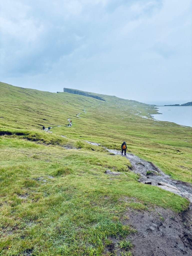
From the reception, the hike is pretty simple and straightforward. You can stop at various view points. Some of the most impressive view points include:
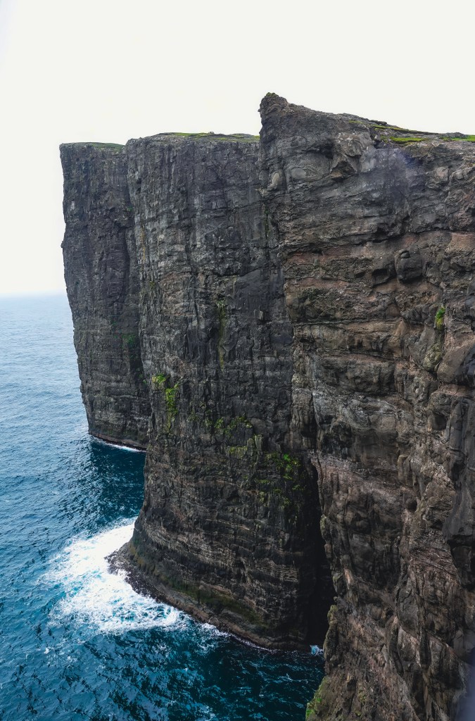
Trælanípa (Viewpoint 1 and 3)
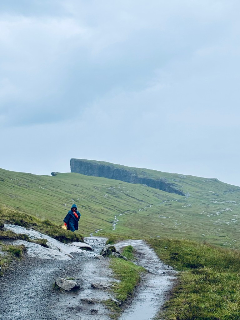
Trælanípa is a magnificent perpendicular rock wall. It juts an impressive 142 meters upwards out of the vast expanse of the sea. This creates a breathtaking sight for all who visit. The name Trælanípa translates to Slave Cliff, a chilling reminder of its dark history. It derives its name from the Viking Age, a time when the harsh realities of survival dictated brutal outcomes. During this period, old and sick slaves who were no longer deemed useful to their masters were callously pushed off the mountain, offering a stark reflection of the values and harshness of that era.
If the cliffs look familiar, it has been used in the Peter Pan and Wendy movie. You can check out more locations in the Faroe Islands that have been shown in the film here.
Lake above the ocean (viewpoint 2)
Continuing on the path, you will take a set stairs to get to the view point of Lake above the ocean. There is a small sign that shows where the best point to stand for the best photos. It was a rainy and cloudy day, but still I managed to get a few decent shots.
Bøsdalafossur Waterfall (Viewpoint 4)
Continue down from the viewpoint of the lake above the ocean. You will have to do some rock scrambling to reach the Bøsdalafossur Waterfall viewpoint. Be careful, as the stones can be slippery especially after rain.
Bøsdalafossur Waterfall falls dramatically from Lake Leitisvatn into the North Atlantic Ocean. It flows from an impressive height of 30 metres (98 feet) above sea level. This creates a stunning visual spectacle that captivates nature lovers and adventurers alike.
From viewpoint 4, you can also see Geituskorardrangur is a free-standing rock wall. This rock formation towers 116 metres (380 feet) above sea level.
Other interesting things on the hike
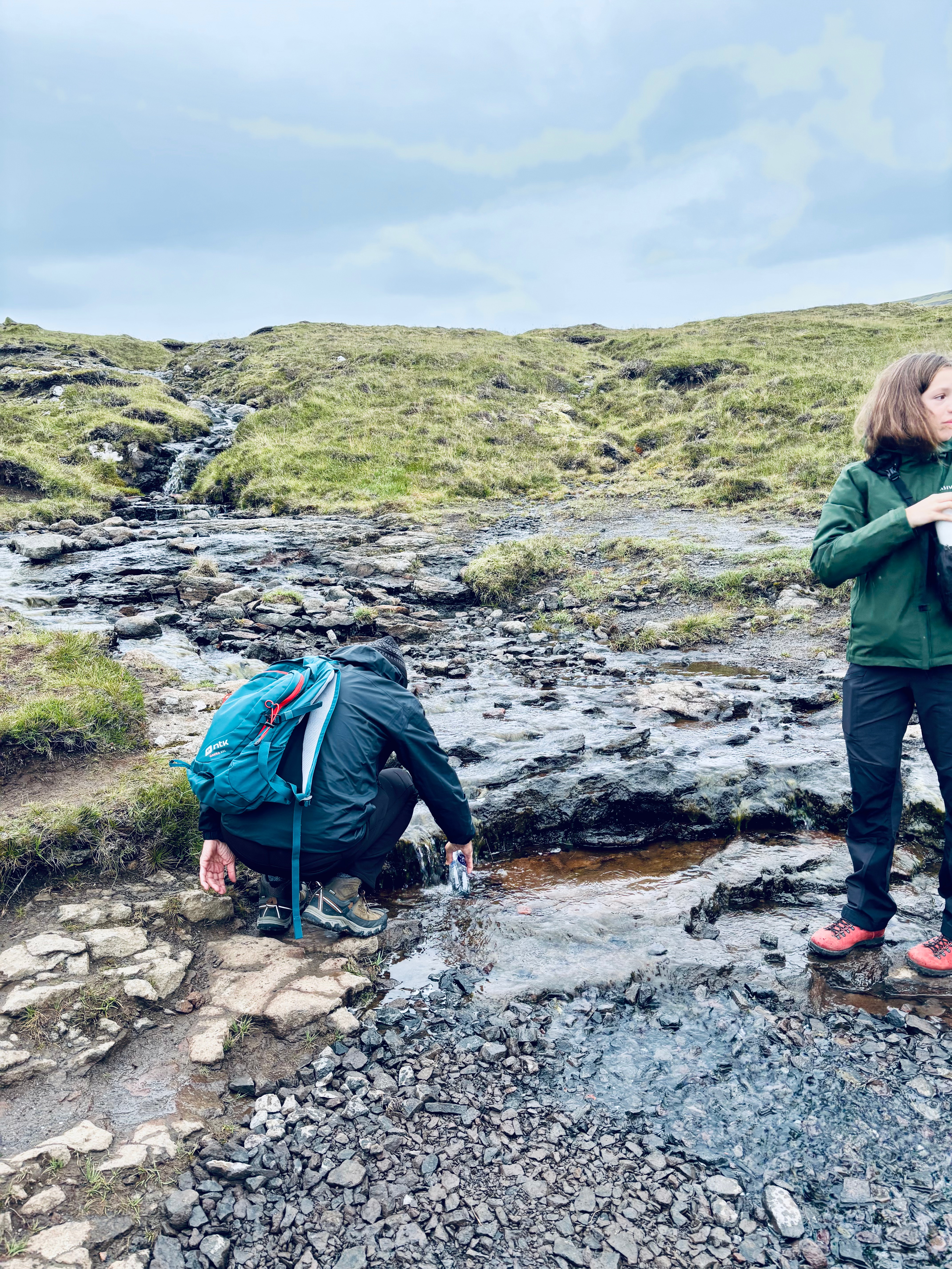
The whole hike is next to the Lake. You will see waterfalls on the way, especially after the rain. These spring waters are safe to drink but make sure you will bottles from the flowing part and not the stagnant water. Our tour group empties our water bottles and fills them with refreshing spring water.
Final thoughts
Hike to Lake above the ocean is a very easy hike with tremendous rewards. This hike can be easily combined with nearby attractions. These include visiting the village of Bøur, Múlafossur Waterfall, and Gásadalur. You can also combine this trip with the boat tour of Drangarnir & Múlafossur. Alternatively, consider the Drangarnir Hiking Tour, especially if you have a car, which gives you more flexibility to explore. Also, stop by the statue of Nix at the other end of the lake, close to the airport.
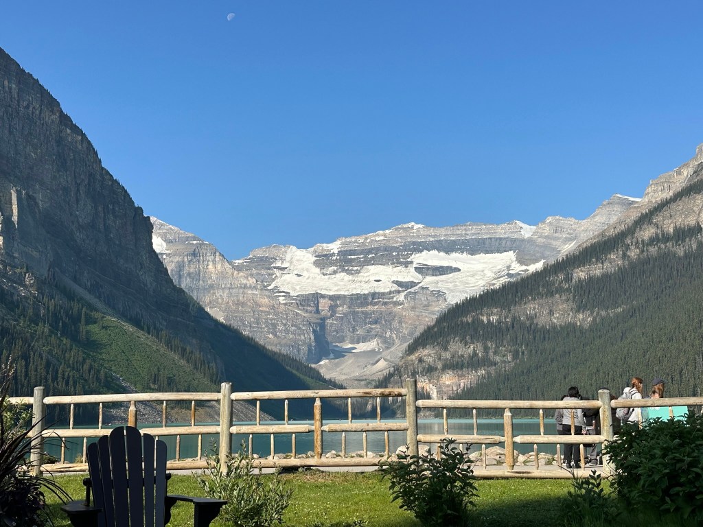
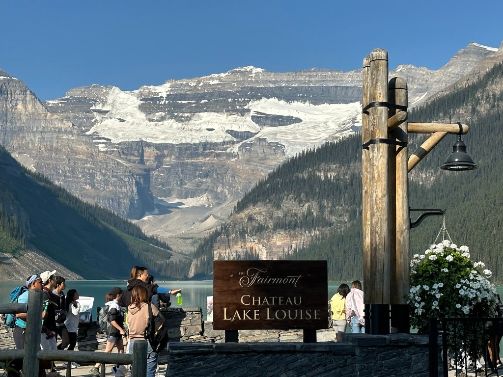
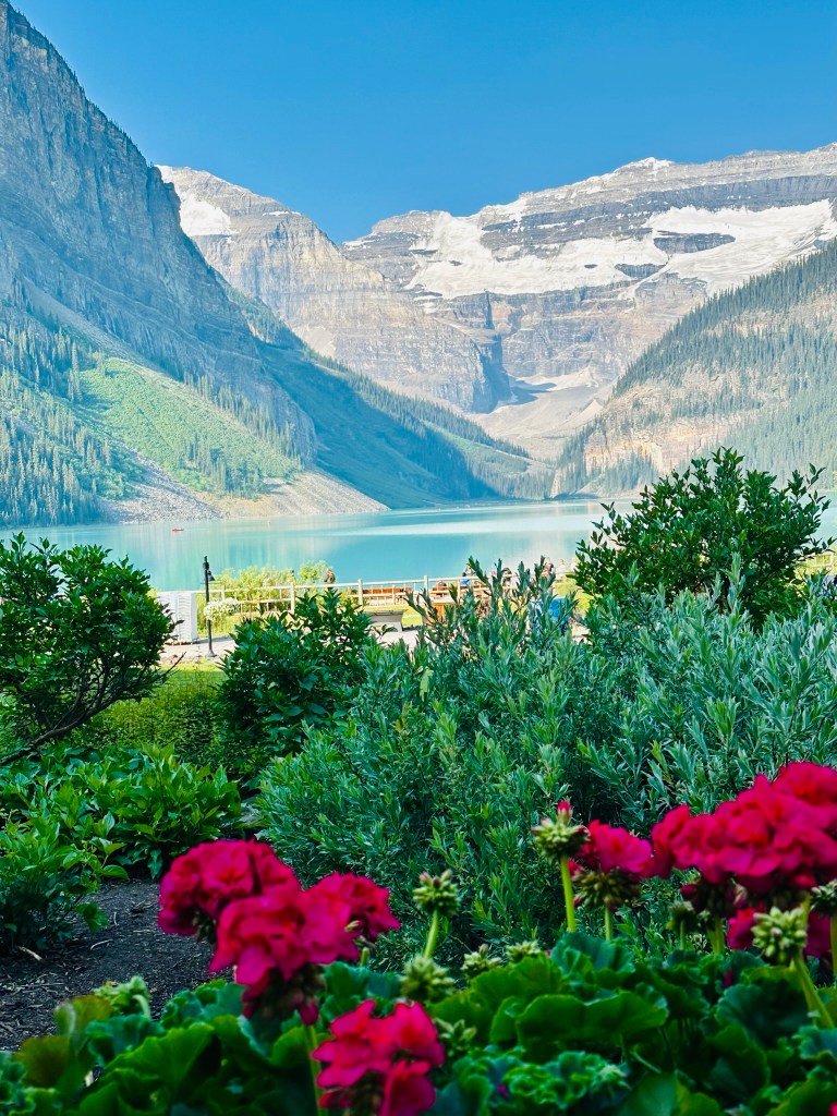
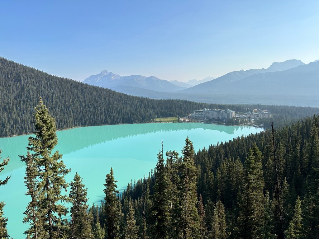
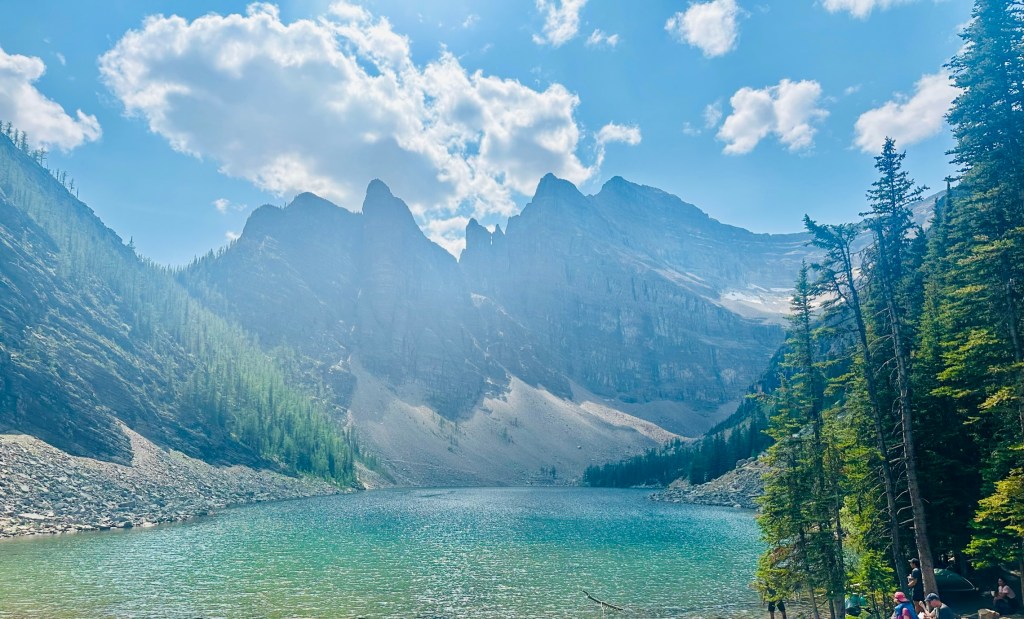
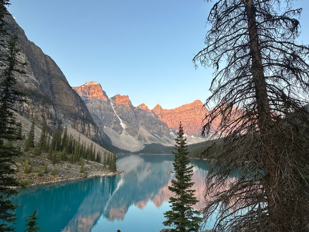
Lake Louise is a stunning alpine lake located in Banff National Park, Alberta, Canada. It is famous for its surreal turquoise waters. These waters are fed by Victoria Glacier. It’s surrounded by towering peaks like Mount Victoria and Mount Whyte, making it one of the most iconic and photographed spots in the Canadian Rockies
Lake Louise is packed with unforgettable experiences—whether you’re chasing adventure, serenity, or postcard-perfect views. Here’s a curated list of must-do activities based on top-rated local spots:
Stay or visit this iconic lakeside hotel for luxury, history, and unbeatable views. Try a cocktail class or indulge in afternoon high tea overlooking the lake
The Fairmont Château Lake Louise began as a one-story log cabin with two bedrooms in 1890. Since then, it has transformed into a grand five-star hotel with a European alpine style. It attracts royalty, celebrities, and guests from around the world, serving as a luxury destination for adventurers and romantics. The hotel offers 539 rooms and 7 restaurants. You don’t need to stay at the hotel to enjoy the property, which features a beautiful garden. Afternoon high tea is popular and can be booked here. You can also have lunch or dinner at one of the on-site restaurants. We got coffee from one of the restaurants and sat in one of the many rocking chairs in the garden and appreciated the million-dollar view.
🛶 Explore Lake Louise Lake shore
Rent a canoe and paddle across the turquoise waters
Walk the Lakeshore Trail for easy access to stunning vistas
You can rent a canoe at Lake Louise from the Fairmont Chateau’s Boathouse. Rentals run daily from 8:30 AM to 8:00 PM during the summer season.
Rental Information
Location: Canoe rentals are available at the Boathouse. It is located on the west shore of Lake Louise. The Boathouse is operated by Fairmont Chateau Lake Louise.
Rental Rates:
For the Public: $170 CAD per hour / $160 CAD for a half-hour (+ tax).
For Hotel Guests: $110 CAD per hour / $100 CAD for a half-hour (+ tax).
Voyageur Canoe Experience: $70 CAD per adult and $30 CAD for youth for hotel guests. For non-hotel guests, it is $85 CAD per adult and $40 CAD for youth.
Capacity: Each canoe can accommodate up to three adults or two adults and two small children (under 55 lbs each). At least one person in the canoe must be 16 or older to rent.
Important Details
Reservations: Canoes are rented on a first-come, first-served basis, so reservations are not accepted. Expect longer wait times during peak summer months.
Hours of Operation: Typically open from 8:30 AM to 8:00 PM, with hours varying based on seasonal conditions. Confirm current hours before your visit, as they change throughout the summer
Special Experiences
Sunrise Canoe Experience: Guests of the Fairmont can enjoy a unique sunrise canoe experience. This allows for a quieter paddle before the crowds arrive. Reservations for this need booking by 10 PM the day before.
Guided Group Canoeing: The Voyageur Canoe Experience allows guests to paddle in a larger canoe with a guide. The guide shares local history and wildlife information.
🥾 Hike Fairview Lookout
Short hike with a big payoff: elevated views of Lake Louise and the Chateau. This was suggested to us by our Radventures and turned out to be one of our favorite hikes.
Trail overview
Trail Length: ~2 km round trip
Elevation Gain: ~170 meters
Difficulty: Easy to moderate
Duration: 30–60 minutes
🌲 What to Expect
The trail starts near the Lake Louise lake shore and winds through a dense forest. Ends at a wooden viewing platform perched above the lake, offering postcard-perfect views of the turquoise waters and surrounding peaks. This hike is excellent for families. It is also perfect if you are short on time. You can still get a view of the hotel and lake from a vantage point.
🥾 Hike to Lake Agnes Tea House
You’re in for a classic Banff adventure! Starting at Lake Louise, you’ll be greeted by its surreal turquoise waters backed by Victoria Glacier and the towering peaks of Mount Victoria and Mount Whyte. From there, the hike to the Lake Agnes Tea House is a scenic and rewarding journey. The Lake Agnes hike is a picturesque and moderately challenging trek in Banff National Park. It leads to the historic Lake Agnes Tea House and offers stunning views of alpine scenery.
🚶♂️ Lake Agnes Tea House Hike Highlights
Trailhead: Begins at Lake Louise lakeshore
Distance: ~7.6 km round trip
Elevation Gain: ~433 m
Duration: 2–4 hours
Difficulty: Easy to moderate
Season: June to mid-October (when the tea house is open)
🌄 What You’ll Experience
You’ll follow a well-maintained path that gradually ascends through lush forests and alongside beautiful lakes.
First Stop – Mirror Lake: After 1.7 km, you’ll come across Mirror Lake, a great place to rest with views of the Big Beehive mountain above.
Second Stop – Waterfall: Just before the final ascent through the stairs, there is a small waterfall.
Third Stop- Lake Agnes
Continuing on, the stairs lead to Lake Agnes, where the iconic tea house awaits. The location of the Tea house couldn’t be any better, and it has been operational since 1901. The tea hose serves various types of teas and baked goods. It is a charming little place to rest and enjoy the natural beauty that surrounds it.
🍵 Lake Agnes Tea House
Built in 1901, serving over 100 types of loose-leaf tea, homemade soups, and fresh baked goods
Open daily 8 am–5 pm, cash preferred (CAD or USD)
No electricity or running water—staff hike supplies up daily!
🧠 Pro Tips
Arrive early to beat the crowds and snag a seat at the tea house
Bring cash, layers, and bear spray
Use restrooms at Lake Louise before starting—there are only two composting toilets at the top
Additional Stops– Big and Little Beehive
Fork in the Trail: At Mirror Lake, hikers have a decision to make. They can detour to the Little Beehive. Alternatively, they can continue to Lake Agnes. It’s suggested to go to Lake Agnes first, then tackle the Little Beehive as an extension. We were too tired to do little beehive and skipped it.
From Lake Agnes to Big Beehive: After visiting the tea house, continue along Lake Agnes. Then, take the ascent via switchbacks to reach the Big Beehive summit. The view of both Lake Agnes and Lake Louie is incredible from Big Beehive. We did not make it to big Beehive
Alternative way to reach Lake Agnes and the tea house– Horse Back riding
Horseback riding to Lake Agnes is another choice if you want to try horseback riding. It’s a great way to reach Lake Agnes if you can’t hike. You can check out the options here.
Booking and Requirements
Rider Requirements: Most ride operators require riders to be at least 8 years old. Riders must also be of a minimum height, usually around 52 inches. Weight limits might apply (commonly 250 lbs)
Booking: Reservations are recommended, especially during peak season. Various tour operators like Brewster Adventures offer different horseback riding packages. These include the Lake Agnes ride. There are options to combine it with other trails such as the Plain of Six Glaciers.
Make sure to check the schedule for departure times. Typically, rides to Lake Agnes are offered around 9:00 am and 1:00 pm, but it is best to confirm directly with the tour operators
🥾 Hike to The Plain of Six Glaciers and the Tea House
Another iconic hike around Lake Louise is in the Plain of the Six Glaciers. Just like Lake Agnes hike, there is a historical Tea house that awaits at the top.
Overview of the Hike
Distance: Approximately 9 miles (14.6 km) out-and-back
Start your hike at the Fairmont Chateau Lake Louise, walking along the scenic Lake Louise shoreline trail. This relatively flat section provides breathtaking views of the lake and surrounding mountains.
After about 2.5 miles( 4 Km), the trail transitions from the lakeside boardwalk to a more rugged path. It climbs through a forested area into an open amphitheater. This amphitheater is filled with glacial features.
The hike culminates at the Plain of Six Glaciers Tea House. This charming establishment dates back to 1927 and has no electricity. It serves light meals and beverages. Visitors can enjoy spectacular views of glaciers and the surrounding peaks while taking a break at the tea house. Remember to bring cash, as it is the preferred method of payment.
For those wanting to extend their hike, a short trail leads to the Abbot Pass viewpoint, offering breathtaking views of multiple glaciers
Moraine Lake is one of the crown jewels of Banff National Park. It captivates visitors with its stunning turquoise waters. Visiting it is truly a bucket-list experience that offers breathtaking views and unparalleled natural beauty. I had this on my bucket list for at least the last 20 years. I eagerly dreamed of the day I would stand at its shores. Finally, I got to see it in person. The moment I arrived, I was awestruck by the vibrancy of the lake’s color. The lake’s color changes throughout the day, reflecting the surrounding peaks and the bright blue sky above. Yet, due to its overwhelming popularity and fragile environment, getting there requires careful planning. Since 2023, all personal vehicles have been banned from Moraine Lake. You need to plan alternative ways to reach the lake. Keep reading to explore all the options to see the majestic Moraine Lake and our personal experience.
🚐 No personal vehicles allowed – Moraine Lake Road is closed to personal vehicles year-round. The only ways to access the lake are:
Parks Canada shuttle (runs June 1 to October 13, every 30 minutes from 6:30 am to 6 pm)
Roam Public Transit Super Pass (includes access to the Lake Connector shuttle)
Licensed commercial tour operators – More on this below
Biking or hiking (for the adventurous!)
Guests of Moraine Lake Lodge or those with accessible parking placards
Best time to visit
Mid-June to late September: From mid-October to late May, the Moraine Lake road is completely closed to vehicles due to avalanche risk and heavy snow
Early morning or evening for fewer crowds and magical lighting
Must-do activities
Hike the Rockpile Trail for the famous “Twenty Dollar View”
Rent a canoe and paddle across glacier-fed waters
Explore nearby trails like Larch Valley or Consolation Lakes
Rock pile
Shuttle Services to Lake Moraine
🚌 To reach Moraine Lake, several licensed commercial operators offer shuttle services from Banff, Lake Louise, and surrounding areas. Here’s a roundup of the most popular and reliable ones.
Pro tip:
Park canada shuttle is the cheapest/Budget way to reach Lake Moraine
🎟️ Reservations required Shuttle seats sell out fast—especially early morning slots. Parks Canada releases 40% of seats in April, and the remaining 48 hours before departure
Extended stays, hotel pickups, hot drinks & blankets
🗓️ Season: Most shuttles operate June 1 to October 13, with sunrise options starting as early as 4 am.
🐾 Pet Policy: Fairview and Moraine Lake Bus Company allow pets (some restrictions apply). Service animals are welcome across all services.
Our personal experience with Moraine Lake Shuttles
We used both Radventures and Fairview Limousine to visit Lake Moraine. Since Lake Moraine had been on my bucket list for such a long time, I didn’t want to take any chances and wait until the last day of our trip for our sunrise shuttle to Lake Moraine in case the weather wasn’t cooperating, as I’ve heard so much about its stunning beauty. To ensure we experienced the breathtaking views, I decided to plan ahead. We stayed at Lake Louise Inn, which was a perfect choice, given its proximity to all the amazing attractions. Fairview Limousine operates out of the Lake Louise Inn, making it incredibly convenient for us. When I found out they had availability for the next morning, I took a solo trip to Lake Moraine on day 1. I embraced the quiet morning solitude. It made the experience even more magical. We also used Fairview to visit Lake Louise for our afternoon hike to Lake Agnes. We truly had the best experience with them. Their drivers were friendly and knowledgeable. They added incredibly valuable insights about the area along the way. One of the great things about Fairview Limousine buses is that they allow dogs, including large dogs.
🌄 Radventures offers some of the most sought-after guided experiences to Moraine Lake and Lake Louise, perfect for catching golden-hour magic or exploring Banff’s alpine beauty without the crowds. We did the Moraine Lake Sunrise and Lake Louise golden hour adventure.
Here are a few standout tours:
🧭 Moraine Lake Sunrise & Lake Louise Golden Hour Adventure
Duration: 7 hours
Highlights: Exclusive sunrise access to Moraine Lake, hot drinks, photography-trained guides, and a peaceful visit to Lake Louise before peak hours
Price: From CAD $269 per person
🌅 Moraine Lake & Lake Louise Sunset Wildlife Adventure
Duration: 5 hours
Highlights: Golden hour at Moraine Lake, sunset at Lake Louise, and a wildlife safari along Bow Valley Parkway with a 95% sighting success rate
Price: From CAD $209 per person
🏞️ Best of Banff National Park Adventure
Duration: 8 hours
Highlights: Full-day tour of Moraine Lake, Lake Louise, and other scenic stops like Vermilion Lakes and Mount Norquay
Price: From CAD $269 per person
All tours include small group sizes, expert local guides, and comfy transport. You’ll get insider tips, storytelling, and plenty of time to explore or take photos.
We were picked up at 4:45 AM from the Lake Louise village and arrived at Lake Moraine by 5:15 AM. We spent the next hour drinking coffee and waiting for sunrise at one of the 3 viewpoints on the rock pile.
🚐 Fairview Limousine and Shuttle Services is Lake Louise’s only locally based transportation company. They’ve built a stellar reputation for getting visitors to Moraine Lake and Lake Louise with ease and style.
🌅 What they offer:
Sunrise shuttles to Moraine Lake (arrive ~1 hour before sunrise)
Hourly shuttles to Moraine Lake and Lake Louise throughout the day
Connector shuttle between the two lakes (8 times daily)
Private charters for weddings, airport transfers, and sightseeing
Luxury limousine service with leather seating, ice bar, and entertainment system
Pet-friendly rides (even large dogs are welcome!)
📍 Departure Point: Lake Louise Inn 🕒 Operating Hours: Daily from 7:15 am to 6:30 pm (varies by season) 💰 Pricing:
Moraine Lake: ~$35 CAD
Lake Louise: ~$25 CAD
Sunrise Shuttle: ~$75 CAD
Combo tickets and group discounts available
Fairview is a fantastic alternative to Parks Canada shuttles—especially if you’re staying in Lake Louise Village or want more flexibility. We had an incredible experience with Fairview Limousine. We took it twice, once to visit Lake Moraine and again to visit Lake Louise. On our way back, the bus was full and we couldn’t get on until next shuttle which was an hour later. The driver of the earlier shuttle called the main desk, and they sent us a car to pick us up without any additional charges.
Final thoughts
At first, planning a trip to Lake Moraine seems like a lot. Nevertheless, it is not difficult once you know which shuttle to use. We prefer convenience and found Fairview Limousine worked best with our location and schedule. Sunrise is definitely a better time to go, but if you can’t make it to the sunrise, any other time still works as well, and the color and beauty of the lake can still be admired throughout the day.
Moraine lake at 7AMMoraine Lake at Sunrise
On the flip side, the sunrise is very crowded, and the photo below shows the behind-the-scenes crowd. Be prepared with lots of patience and good humor.
Talk about a trifecta of national parks to visit….
🌍 Into the Wild Beauty of the Canadian Rockies
If you’ve ever dreamed of stepping into a postcard, the Canadian Rockies are where that vision comes to life. Straddling the provinces of Alberta and British Columbia, this mountain wonderland is breathtaking. It is home to some of the most jaw-dropping natural beauty on Earth. At the heart of it all are three iconic national parks: Banff, Yoho, and Jasper. Each park offers its own flavor of adventure, tranquility, and untamed charm.
🏞️ Banff is where it all began: Canada’s first national park, and a global symbol of alpine beauty.
🌄 Lake Louise & Moraine Lake Technically within Banff, but worth highlighting on their own. These iconic lakes are must-sees for their surreal colors and dramatic mountain backdrops. Sunrise at Moraine Lake? Pure magic.
💦 Yoho may be smaller, but don’t let size fool you. This hidden gem features towering waterfalls, Tranquil lakes, and ancient fossils.
To read more about spending a day a Yoho National Park, click here
🌌 Jasper, the wildest of the trio, beckons those looking to get off the beaten path. Jasper boasts vast backcountry and an abundance of wildlife. Its skies are so dark they’ve been named a dark-sky preserve.
If you are already exploring Banff and the surrounding areas and have more days to spend, here are a few other noteworthy National Parks and hidden gems to add to your itinerary
🧭 Kootenay National Park– Just south of Yoho, Kootenay offers a quieter experience. It is less traveled with dramatic canyons. You can find hot springs and colorful mineral pools. Don’t miss Marble Canyon or the steamy Radium Hot Springs for a relaxing soak after your hikes.
🏔️ Icefields Parkway– This legendary highway connects Banff and Jasper and is a destination in itself. Along the way, you’ll pass glaciers, turquoise lakes, and epic viewpoints like Peyto Lake and the Columbia Icefield. It’s one of the most scenic drives in the world.
🌲 Canmore, Located just outside Banff National Park, is a charming mountain town. It has a laid-back vibe and great food. You can access beautiful hikes like Ha Ling Peak and Grassi Lakes. It’s perfect for travelers who want a less touristy base.
🛶 Waterton Lakes National Park A bit farther south, this lesser-known park borders Montana’s Glacier National Park. It’s a UNESCO World Heritage Site, boasting stunning lakes, wildflower-filled meadows, and a peaceful, off-the-beaten-path ambiance.
Our Itinerary
What we did: Spent 3 days in Lake Louise Village and did hikes, canoeing, and drove the Icefields Parkway.
Where we stayed: Lake Louise Inn
Days 1 and 5: Travel Days
Day 2: Explore Yoho National Park and Johnston Canyon
Day 3: Drive the Icefields Parkway. Stop at various viewpoints like Lake Peyto, Mistaya Canyon, and the Columbia Icefields. Visit the Athabasca Glacier. Evening -explore Banff downtown
Day 4: Sunrise visit to Lake Moraine with Radventures. Afternoon visit to Lake Louise with Fairview Limousine and hike to Lake Agnes Tea House